Road Photos &
Information: New South Wales
| M1 A1
|
|
Pacific
Motorway, Pacific Highway, New England Highway, John Renshaw Drive,
Gore Hill Freeway, Warringah Freeway, Sydney Harbour Tunnel, Cahill
Expressway, Eastern Distributor, Southern Cross Drive, General
Holmes Drive, The Grand Parade, President Avenue, Princes Highway
& Princes Motorway (M1 / A1) - Bodalla to Cobargo |
Statistics:
- Length: 1354 km
(Bodalla to Cobargo: 55 km)
- Northern Terminus: Queensland
Border at Tweed Heads, continues as Pacific Motorway (M1)
- Southern Terminus: Victorian
Border at Timbillica, continues as Princes Highway (A1)
- Suburbs, Towns & Localities Along Route: Dalmeny,
Narooma, Corunna, Central Tilba, Tilba Tilba, Dignams Creek and
Cobargo
Route Numbering:
- Former:

- Road Authority Internal Classification: HW1 (Victorian border to Yallah and Waterfall to
Kogarah) 1
General Information:
The Princes Highway was formed from a string of roads
linking Sydney to the Illawarra, and then forming a coastal route to
Melbourne and into South Australia. The section covered by A1 is in 2
pieces - between Rockdale and Waterfall in Sydney, and then Yallah near
Wollongong through to the Victorian Border. The route is a mix of urban
arterial road, dual carriageway and also rural highway.
History:
- 7 June 1926: The Princes Highway comes under a federal and state
government £ for £ funding scheme, thus recognizing the importance of
the highway as major route.
- 1881: Construction of the Nowra Bridge over the Shoalhaven River
- August 1920: Official opening of Princes Highway performed at Warragul
in Victoria. The formation of the Princes Highway is from existing roads
being renamed, after the visit to Australia in 1920 of the Prince of
Wales (later to become King Edward VIII, and after abdicating, the Duke
of Windsor).
- 1 July 1928: Princes Highway became a state highway. 2
- 1939: By the middle of the year, 300 miles (or 50% of the then
highway) had been paved with bitumous surface.
- 1932: Completion of steel truss and bascule lift span bridge over the
Wagonga River at Narooma. 3
- 1935: Construction of pre-stressed concrete bridge at Dignams Creek.
Construction of bridge over Victoria Creek at Central Tilba. Roads &
Maritime Services, Projects, Princes Highway upgrade, Victoria
Creek.
- 1939: By the middle of the year, 300 miles (or 50% of the then
highway) had been paved with bitumous surface.
- 1957: First post-tensioned concrete bridges built by the DMR were
completed on the Princes Highway over Corunna Lake and Nangudga Lake
near Narooma. 3
- March 2011: Work started on replacement bridge over Nangudga Lake near
Narooma. 4
- 16 December 2011: Completion of replacement bridge over Nangudga Lake.
4
- 16 January 2013: Opening of replacement bridge over Victoria Creek and
associated realignment works at Central Tilba. 5
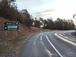 |
Advance Directional Sign:
AD sign, southbound on Princes Hwy at Tilba Tilba approaching
Bermagui Rd, May 2011.
Image © Paul Rands
|
Click
here for the Princes Hwy (A1) between Cobargo and Bega
Click here for
the continuation of the Princes Hwy (A1) between Batemans Bay and
Bodalla |
1 Roads &
Maritime Services, Schedule of Classified Roads and Unclassified Regional
Roads, August 2013.
2 Main Roads Board, Annual Report,
Volume 1, Number 1, September 1929.
3 Roads & Traffic Authority,
Thematic History, 2nd Edition, 2006.
4 Roads & Maritime Services,
Projects, Princes Highway upgrade, Nangudga Lake Bridge replacement.
5 Roads & Maritime Services,
Projects, Princes Highway upgrade, Victoria Creek.
Last updated: 22-Dec-2019 19:36
This site ©
Paul
Rands. All rights reserved. Some portions © (copyright) by their
respective and credited owners. Permission must be obtained before using
any images from this site. For details, please email by clicking
here.
