Australian Towns & Cities
Queensland: Fernvale
Incorporating photos and Information
from Michael Greenslade's former Australian Towns, Cities and Highways
site
Fernvale, located on the Brisbane Valley Highway between Esk and Ipswich, lies in a small fertile valley with its economic base mainly consisting of fruit & vegetable crops with some beef farming. The town lies just to the south of the Wivenhoe Dam wall and backs onto the Brisbane River. For an alternative and scenic route to Brisbane, motorists should follow the Brisbane Valley Hwy 5km north to the Somerset turnoff and head north towards Dundas, then east through the Cabbage Tree Range, Mt Glorious and Mt Nebo before reaching the Brisbane metro area.
- Population: 3209 1
- Postcode: 4306
- Location: 60 km west of Brisbane
- Main Roads: Brisbane Vly Hwy


- Radio Stations: DAB+: 4BC, 4BH, 4KQ, 4TAB Digital Two, 97.3 The 80s, 97.3 The 90s, ABC Classic, ABC Country, ABC Jazz, ABC Kids Listen, ABC News on Radio, ABC Radio Brisbane, ABC RN, ABC Sport, B105, Bhudda Hits, Chemist Warehouse Remix, Coles Radio, Dance Hits, Double J, Hot 91, Easy 80s Hits, iHeartCountry Australia, KIIS 97.3, News Talk Sport, Nova 90s, Nova 106.9, Oldskool 90s Hits, RadioTAB, SBS Arabic24, SBS Chill, SBS PopAsia, SBS PopDesi, SBS Radio 1, SBS Radio 2, SBS Radio 3, Smooth 80s Brisbane, Smooth FM Brisbane, SoundCloud Radio, The Edge Digital, TikTok Trending on iHeartRadio, Triple J, Triple J Unearthed, Triple M 90s, Triple M Classic Rock, Triple M Country, Triple M Hard n Heavy, Triple M Soft Rock, and Urban Hits. FM: 97.3 FM (97.3 MHz), ABC Classic (106.1 MHz), B105 (105.3 MHz), Nova (106.9 MHz), River 94.9 (94.9 MHz), Triple J (107.7 MHz), Triple M Brisbane (104.5 MHz), and Vision Radio Network (87.8 MHz). AM: 4BC (1116 kHz), 4BH (882 kHz), 4KQ (693 kHz), ABC News on Radio (936 kHz), ABC Radio Brisbane (612 kHz), ABC RN (792 kHz) and ABC Southern QLD (747 kHz)
View Larger Map
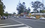 |
Fernvale Town Centre:
The Brisbane Valley Hwy, heading northwest through Fernvale, July 2004.
Image © Michael Greenslade
|
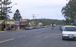 |
Fernvale Town Centre:
The Brisbane Valley Hwy, looking southeast through Fernvale, July 2004.
Image © Michael Greenslade |
1 Australian Bureau of Statistics, 2016 Census Quickstats, Fernvale SSC
Last updated: 28-Oct-2021 14:02
This site ©
Paul
Rands. All rights reserved. Some portions © (copyright) by their
respective and credited owners. Permission must be obtained before using
any images from this site. For details, please email by clicking
here.

