|
|
|
|
|
| C142 | Eastland Drive, Main Street, Crescent Street, Kings Parade, Hobbs Parade, South Road and Knights Road (C142) |
Statistics:
Route Numbering:

 1
1General Information:
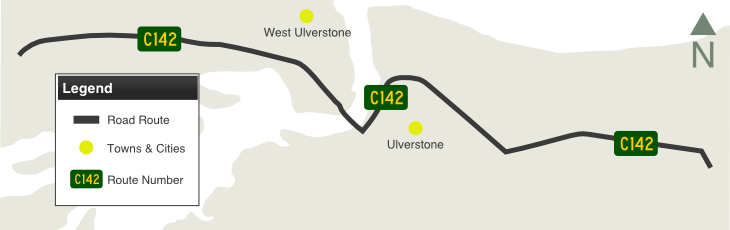
C142 is the former Bass Highway alignment through the Ulverstone area on Tasmania's north coast and is part of the Great Nature Trail themed tourist drive.
The route features a bridge over the River Leven and is mostly undivided for most of its length, passing through residential, light industrial and commercial areas. It serves a very rich farming district and is the main tourist access route to Leven Canyon, a fairly spectacular state park including the very deep gorge of the Leven River. 2
History:
| Ulverstone to West Ulverstone | West Ulverstone to Ulverstone | |||
| Preview: | Description: | Preview: | Description: | |
 |
Intersection Directional Sign: ID sign on Crescent St (C142) facing Reibey St at Ulverstone, August 2011. The NH1 shields should be prefixed with 'To' or 'Via'. Image © Peter Renshaw |
 |
Leven River Bridge The new Leven River Bridge, West Ulverstone, August 2011. Image © Peter Renshaw |
|
 |
Leven River Bridge: The Leven River Bridge, with the old one under deconstruction alongside it, Ulverstone, August 2011. Image © Peter Renshaw |
 |
Old Leven River Bridge: Old bridge next to the new bridge, West Ulverstone, August 2011. Image © Peter Renshaw |
|
1 Sam laybutt (Ozroads)
2 Peter Renshaw
3 Parliament of Tasmania, Parliamentary Standing Committee on Public Works, Reports, Replacement of the Leven River Bridge, 2009
Last updated: 10-Feb-2019 14:03
This site © Paul Rands. All rights reserved. Some portions © (copyright) by their respective and credited owners. Permission must be obtained before using any images from this site. For details, please email by clicking here.