|
|
|
|
|
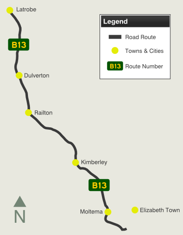
| B13 | Kimberley Road & Railton Road (B13) |
Statistics:
Route Numbering:
General Information:
B13 is rural route in northern Tasmania, which runs somewhat in parallel with Bass Highway (NH1).
History:
| Elizabeth Town to Latrobe | Latrobe to Elizabeth Town | |||
| Preview: | Description: | Preview: | Description: | |
 |
Advance Directional Sign: AD eastbound on Bass Highway at Elizabeth Town. October 2007. Image © Peter Renshaw |
 |
Advance Directional Sign: AD westbound on Mersey Main Rd (B19) at Latrobe. October 2007. Image © Peter Renshaw |
|
 |
Northbound at Moltema: Railton Rd view north from Brooklyn Rd (C161) at Moltema (note the old mile post to the left of the road). October 2007. Image © Peter Renshaw |
|||
 |
Advance Directional Sign: AD sign on Kimberley Rd (B13) approaching Crocker St, Foster St (B13 & B14) at Railton. November 2007. Image © Peter Renshaw |
|||
1 Meander Valley Council, 2008/2009 Capital Works Programme, May 2008
Last updated: 10-Feb-2019 13:57
This site © Paul Rands. All rights reserved. Some portions © (copyright) by their respective and credited owners. Permission must be obtained before using any images from this site. For details, please email by clicking here.