|
|
|
|
|
| Boonah-Fassifern Road, Ipswich-Boonah Road, Beaudesert-Boonah Road, Mount Lindesay Highway, Beaudesert-Nerang Road, Beaudesert-Beenleigh Road, Mundoolun Connection Road, Nerang Connection Road & Nerang-Broadbeach Road (State Route 90) - Canungra to Bromelton |
Statistics:
Route Numbering:


General Information:
State Route 90 is a collection of roads connecting the Cunningham Highway (and eventually the Darling Downs) with the Gold Coast.
West of Nerang the route is a rural style route, and east of Nerang the route takes on an suburban arterial road design.
Several major routes are connected by SR90, including Cunningham Hwy (NH15), Mt Lindesay Hwy (NR13), Pacific Mwy (M1) and Gold Coast Hwy (SR2).
Multiplexes along the route include:
History:
| Canungra to Bromelton | Bromelton to Canungra | |||
| Preview: | Description: | Preview: | Description: | |
 |
Advance
Directional Sign: AD sign approaching the unnumbered sectionof Beaudesert-Nerang Rd (Wonglepong Rd) at Wonglepong, June 2010. SR90 continues as Mundoolun Connection Rd from this junction. Image © Rob Tilley |
 |
Trailblazer: SR90 trailblazer at Bromelton, June 2010. Image © Rob Tilley |
|
 |
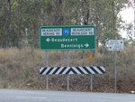
Beaudesert-Beenleigh
Road: Mundoolun Connection Rd (SR90) at the junction with Beaudesert-Beenleight Rd (SR90 / SR92) at Tamborine, October 2009. The TD16 multiplex begins at this junction. Image © Rob Tilley |
 |
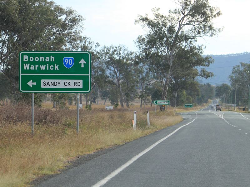
Advance
Directional Sign: AD sign approaching Sandy Creek Road at Bromelton, June 2010. Image © Rob Tilley |
|
 |
Advance
Directional Sign: AD sign on the unnumbered section of Beenleigh-Nerang Rd at Tabragalba approaching Beaudesert-Nerang Rd (SR90) and Beaudesert-Beenleigh Rd (SR90), June 2010. Image © Rob Tilley |
 |
Distance
Sign: RD sign as SR90 leaves Bromelton, June 2010. Image © Rob Tilley |
|
 |
Intersection
Directional
Sign: ID sign at Tabragalba facing the unnumbered section Beaudesert-Nerang Rd (Wonglepong Rd), June 2010. Image © Rob Tilley |
 |
Intersection
Directional
Sign: ID sign facing Beaudesert-Boonah Rd (Bromelton St) (SR90) at Beaudesert, June 2010. The NR13 and TD16 multiplex begins at this junction. Image © Rob Tilley |
|
 |
Distance
Sign: RD sign at Tabragalba, June 2010. Image © Rob Tilley |

|
Intersection
Directional
Sign: ID sign assembly at the junction with Brisbane St and Mt Lindesay Hwy (NR13) at Beaudesert, June 2010. The NR13 multiplex ends at this junction. Image © Rob Tilley |
|
 |
Advance
Directional Sign: AD sign at Beaudesert approaching Albert St and Tina St, June 2010. Image © Rob Tilley |
 |
Trailblazer: SR90 trailblazer in the Beaudesert CBD, October 2009. Image © Rob Tilley |
|
 |
Advance
Directional Sign: AD sign approaching Mt Lindesay Hwy (NR13) and Brisbane St in Beaudesert, June 2010. Image © Rob Tilley |

|
Reassurance
Directional
Sign: RD sign as Beaudesert-Nerang Rd (SR90) leaves Beaudesert, October 2009. Image © Rob Tilley |
|
 |
Trailblazer: SR90 trailblazer approaching Mt Lindesay Hwy (NR13) and Brisbane St in Beaudesert, June 2010. Image © Rob Tilley |

|
Advance
Directional Sign: AD sign at Tabragalba approaching the unnumbered section of Beaudesert-Nerang Rd (Wonglepong Rd), October 2009. Image © Rob Tilley |
|
 |
Mt
Lindesay Highway & Brisbane Street: ID sign assembly at the junction with Mt Lindesay Hwy (NR13) and Brisbane St in Beaudesert, February 2014. The NR13 multiplex starts at this junction. Click here for a photo of this location by Rob Tilley from June 2010. Image © Michael Greenslade |
 |
Beaudesert-Nerang
Road: ID sign at the unnumbered section of Beaudesert-Nerang Rd in Tabragalba, October 2009. SR90 continues as Mundoolun Connection Rd from this junction. Image © Rob Tilley |
|
 |
Distance
Sign: RD sign in the Beaudesert CBD, June 2010. Image © Rob Tilley |
 |
Entering
Birnam: Mundoolun Connection Rd (SR90) as it enters the town of Birnam, October 2009. Image © Rob Tilley |
|
 |
Advance
Directional Sign: AD sign approaching Beaudesert-Boonah Rd (SR90) (Bromelton St) at Beaudesert, June 2010. The NR13 and TD16 multiplex ends at this junction. Image © Rob Tilley |
 |
RD
sign: Distance sign as SR90 leaves Birnam, October 2009. Image © Rob Tilley |
|
 |
Intersection
Directional
Sign: ID sign at Beaudesert-Boonah Rd (SR90) (Bromelton St) at Beaudesert, June 2010. The NR13 and TD16 multiplex ends at this junction. Image © Rob Tilley |
 |
Supplemental
Advance
Directional Sign: Supplemental AD sign at Tamborine approaching Beaudesert-Beenleigh Rd (SR92), October 2009. Image © Rob Tilley |
|
 |
Intersection
Directional
Sign: ID sign at Beaudesert-Boonah Rd (SR90) (Bromelton St) at Beaudesert, June 2010. The NR13 and TD16 multiplex ends at this junction. Image © Rob Tilley |
 |
Advance
Directional Sign: AD sign at Tamborine approaching Beaudesert-Beenleigh Rd (SR92), October 2009. SR90 turns right at this intersection. Image © Rob Tilley |
|
 |
Distance
Sign: Reassurance directional sign as SR90 leaves Beaudesert, June 2010. Image © Rob Tilley |
 |
Intersection
Directional
Sign: ID sign assembly at the junction with Beaudesert-Beenleigh Rd (SR92), October 2009. SR90 turns right at this intersection. Image © Rob Tilley |
|

|
Trailblazer: SR90 trailblazer near Bromelton House Rd at Bromelton, June 2010. Image © Rob Tilley |
 |
End
Tourist Drive 16: Sign marking the end of TD16 at Tamborine, October 2009. Image © Rob Tilley |
|
 |
Advance
Directional Sign: AD sign approaching Sandy Ck Rd at Bromelton, June 2010. Image © Rob Tilley |
 |
Intersection
Directional
Sign: ID sign assembly at the junction with Beaudesert-Beenleigh Rd (SR92), October 2009. SR90 turns right at this intersection. Image © Rob Tilley |
|
 |
Distance
Sign: RD sign as Beaudesert-Boonah Rd (SR90) leaves Bromelton, June 2010. Image © Rob Tilley |
 |
Distance
Sign: RD sign at Tamborine, after the SR92 junction, October 2009. Image © Rob Tilley |
|

|
Advance
Directional Sign: AD sign approaching the SR90 section of Beaudesert-Nerang Rd and the unnumbered section of Beaudesert-Nerang Rd (Wonglepong Rd), October 2009. Note the incorrect facing arrowhead on the name patch for Wonglepong Rd. Image © Rob Tilley |
|||
| Click
here for the continuation of State Route 90 between
Broadbeach and
Canungra Click here for the continuation of State Route 90 between Bromelton and Fassifern |
||||
1 Transport
and Main Roads, Queensland state-controlled roads and region maps, South
Coast Region: front
2 Queensland Government, Ministerial
Media Statements, Minister for Infrastructure and Planning, Opportunity to
see Wyaralong Dam Project. 13
August 2010.
3 Transport and Main Roads,
Projects, Reynolds Creek Bridge Replacement, June 2010.
Last updated: 02 Nov 2019 11:19
This site © Paul Rands. All rights reserved. Some portions © (copyright) by their respective and credited owners. Permission must be obtained before using any images from this site. For details, please email by clicking here.