|
|
|
|
|
| B65 | Bulli Pass, Princes Highway, Memorial Drive, Bourke Street, Corrimal Street, Springhill Road, Five Islands Road, King Steet, Primbee Deviation, Windang Road & Shellharbour Road (B65) |
Statistics:
Route Numbering:


General Information:
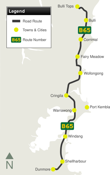
B65 is a major coastal north-south route through the Illawarra region, south of Sydney.
It consists of a mix of undivided 2-lane and 4-lane roads and divided arterial roads, which pass through residential, commercial and heavy industrial areas. The route sees a mix of local and commuter traffic along with large volumes of truck traffic servicing Port Kembla and the BHP Biliton Steelworks. The route between Bulli Tops and Bulli, and also through Shellharbour, originally formed part of the main route between Sydney and the New South Wales South Coast, but was superseded by the Princes Motorway (M1) as the main link through the Illawarra. Some of the route forms part of Grand Pacific Drive.
Multiplexes along the route include:
History:
| Dunmore to Bulli Tops | Bulli Tops to Dunmore | |||
| Preview: | Description: | Preview: | Description: | |
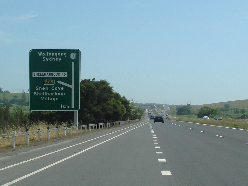 |
Advance Directional Sign: AD sign on Princes Hwy (A1) at Dunmore approaching Shellharbour Rd (B65) and Lindsays Ln interchange, October 2010. Image © Paul Rands |
 |
Advance Directional Sign: AD sign on Princes Hwy at North Wollongong approaching the Memorial Dr (B65) interchange, December 2013. Image © Michael Greenslade |
|
 |
Advance Directional Sign: AD sign on Northcliffe Dr approaching King St (B65) in Warrawong, November 2013. Image © Paul Rands |
 |
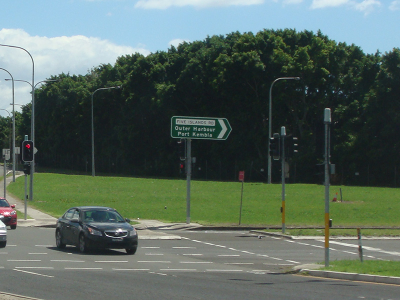
Intersection Directional Sign: ID sign at Port Kembla, facing Wattle St, at the junction with Five Islands Rd (B65 & unnumbered) and King St (B65), June 2013. Image © Paul Rands |
|
 |
Intersection Directional Sign: ID sign on the corner of Northcliffe Dr and King St (B65) in Warrawong, November 2013. Image © Paul Rands |
 |
Intersection Directional Sign: ID sign at Port Kembla, facing Wattle St, at the junction with Five Islands Rd (B65 & unnumbered) and King St (B65), June 2013. Image © Paul Rands |
|
 |
Advance Directional Sign: AD sign on King St (B65) in Warrawong approaching the unnumbered section of Five Islands Rd and Wattle St, November 2013. B65 becomes Five Islands Rd at this junction. Image © Paul Rands |
 |
Entering Warrawong: King St (B65) as it enters the suburb of Warrawong, June 2013. Image © Paul Rands |
|
 |
Five Islands Road & Wattle Street: King St (B65) in Warrawong at the unnumbered section of Five Islands Rd and Wattle St, November 2013. B65 becomes Five Islands Rd at this junction. Image © Paul Rands |
 |
King Street: Looking south on King Street in Warrawong, June 2013. Image © Paul Rands |
|
 |
Advance Directional Sign: AD sign on Five Islands Rd (B65) at Port Kembla North approaching Flinders St, November 2013. Image © Paul Rands |
 |
Advance Directional Sign: AD sign on King St (B65) Warrrawong, approaching Northcliffe Dr, June 2013. Image © Paul Rands |
|
 |
Flinders Street: Five Islands Rd (B65) at Port Kembla North at the junction with Flinders St, November 2013. Image © Paul Rands |
 |
Intersection Directional Sign: ID sign at the corner of King St (B65) and Northcliffe Dr, Warrawong, June 2013. Image © Paul Rands |
|
 |
Supplemental Advance Directional Sign: Supplemental AD sign for Grand Pacific Drive tourist route approaching Lake Av and Springhill Rd at Cringila, November 2013. Image © Paul Rands |
 |
Distance Sign: Grand Pacific Drive reassurance directional sign at Warrawong, June 2013. Image © Paul Rands |
|
 |
Advance Directional Sign: AD sign for Grand Pacific Drive tourist route approaching Lake Av and Springhill Rd at Cringila, November 2013. Image © Paul Rands |
 |
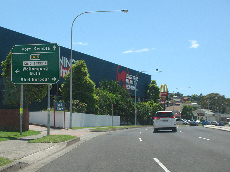
Shellharbour Road: King St (B65) at the junction with Shellharbour Rd (B65 and unnumbered) at Warrawong, June 2013. Image © Paul Rands |
|
 |
Intersection Directional sign: ID sign at the corner of Five Islands Rd (B65) and Lake Av in Cringila, November 2013. Image © Paul Rands |
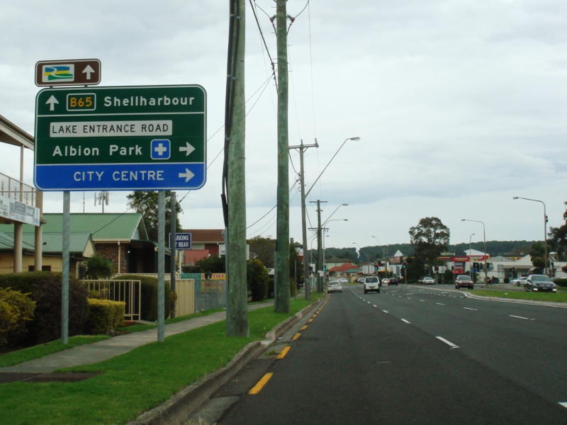 |
Advance Directional Sign: AD sign on Shellharbour Rd (B65) at Warilla, approaching Lake Entrance Rd and George St, June 2013. Image © Paul Rands |
|
 |
Intersection Directional sign: ID sign at the corner of Five Islands Rd (B65) and Springhill Rd (B65) in Cringila, November 2013. Image © Paul Rands |
 |
Advance Directional Sign: AD sign on Shellharbour Rd (B65) at Warilla approaching Sunset Av, June 2013. Image © Paul Rands |
|
 |
Intersection Directional sign: ID sign at the corner of Five Islands Rd (B65) and Springhill Rd (B65) in Cringila, November 2013. Image © Paul Rands |
 |
Distance Sign: Reassurance directional sign on Shellharbour Rd (B65) at Barrack Heights, June 2013. Image © Paul Rands |
|
 |
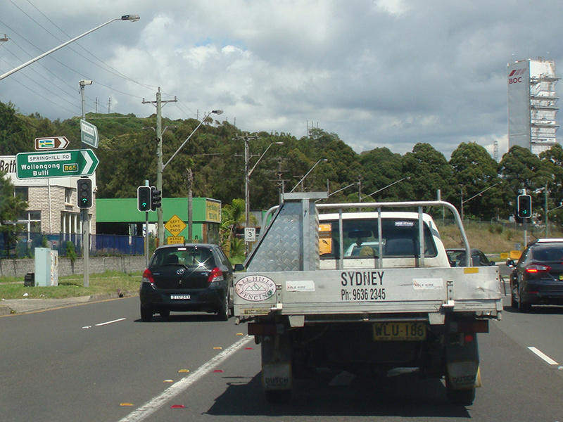
Advance Directional Sign: AD sign on Springhill Rd (B65) approaching Masters Rd in Spring Hill, November 2013. Image © Paul Rands |
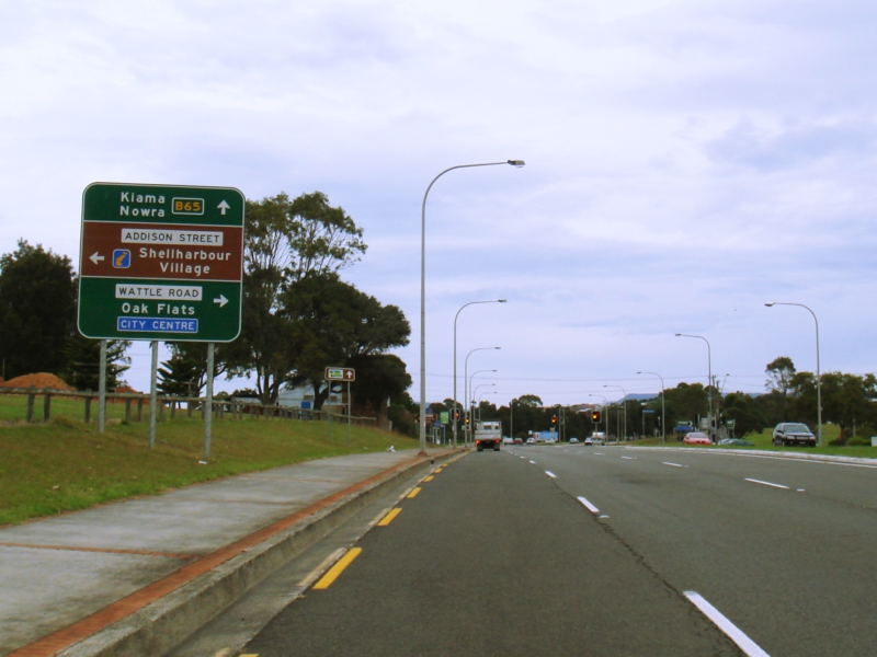 |
Advance Directional Sign: AD sign approaching Addison St and Wattle Rd at Shellharbour, June 2013. Image © Paul Rands |
|
 |
Masters Road: ID sign at the Masters Rd junction at Spring Hill, November 2013. Image © Paul Rands |
 |
Intersection Directional Sign: ID sign at the corner of Addison St and Wattle Rd at Shellharbour, June 2013. Image © Paul Rands |
|
 |
Distance Sign: Reassurance directional sign at Spring Hill, November 2013. Image © Paul Rands |
|||
 |
Advance Directional Sign: AD sign approaching Tom Thumb Rd at Coniston, November 2013. Image © Paul Rands |
|||
 |
Tom Thumb Road: Corner of Springhill Rd (B65) and Tom Thumb Rd at Coniston, November 2013. Image © Paul Rands |
|||
 |
Keira Street: Springhill Rd (B65) at the junction with Keira St, Wollongong, November 2013. Image © Paul Rands |
|||
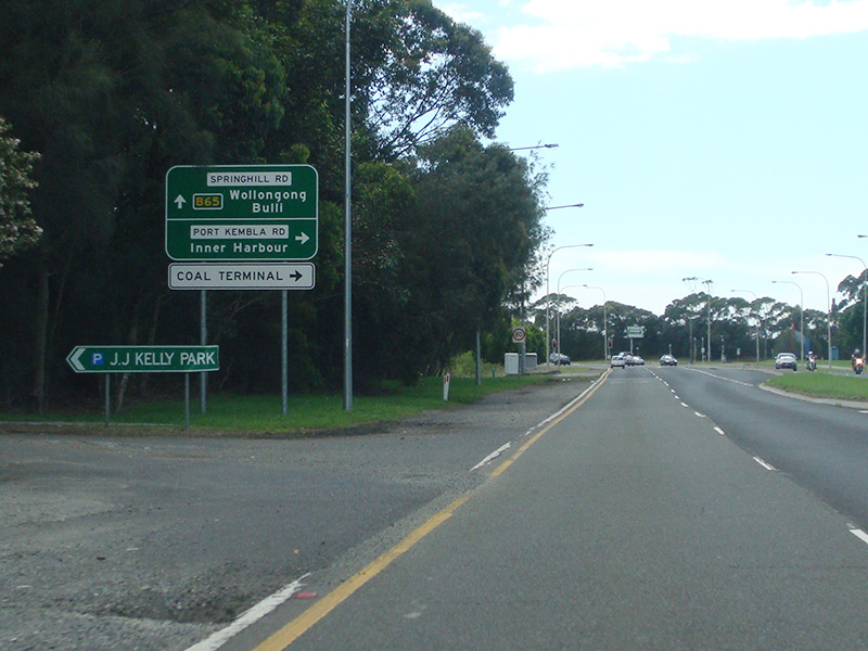 |
AD sign: Advance directional sign near JJ Kelly Park in Wollongong approaching Port Kembla Rd, November 2013. Image © Paul Rands |
|||
 |
Port Kembla Road: Corner of Springhill Rd (B65) and Port Kembla Rd in Wollongong, November 2013. B65 becomes Corrimal Street beyond this junction. Image © Paul Rands |
|||
 |
Advance Directional Sign: AD sign on Corrimal St (B65) approaching Stewart St, November 2013. Image © Paul Rands |
|||
 |
Stewart Street: Corner of Corrimal St (B65) and Stewart St in Wollongong, November 2013. Image © Paul Rands |
|||
 |
Trailblazer: Grand Pacific Drive trailblazer appaoching Crown St, Wollongong, November 2013. Image © Paul Rands |
|||
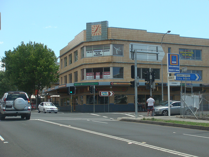 |
Crown Street: Corner of Corrimal St (B65) and Crown St, Wollongong, November 2013. Image © Paul Rands |
|||
 |
Market Street: Corner of Corrimal St (B65) and Market St in Wollongong, November 2013. Image © Paul Rands |
|||
 |
Advance Directional Sign: AD sign approaching Kembla St and Bourke St in North Wollongong, November 2013. B65 turns left at this junction. Image © Paul Rands |
|||
 |
Intersection Directional Sign: ID sign at the corner of Corrimal St (B65), Bourke St (B65 / unnumbered) and Kembla St in North Wollongong, November 2013. Image © Paul Rands |
|||
 |
Intersection Directional Sign: ID sign at the corner of Corrimal St (B65), Bourke St (B65 / unnumbered) and Kembla St in North Wollongong, November 2013. Image © Paul Rands |
|||
 |
Advance Directional Sign: AD sign on Bourke St (B65) approaching Flinders St (B65) in Wollongong, November 2013. Image © Paul Rands |
|||
 |
Intersection Directional Sign: ID sign facing Bourke St (B65) in North Wollongong, November 2013. B65 turns right at this junction. Image © Paul Rands |
|||
 |
Advance Directional Sign: AD sign approaching Memorial Dr (B65) and Princes Hwy at North Wollongong, November 2013. Image © Paul Rands |
|||
 |
Intersection Directional Sign: ID sign at the on ramp to the unnumbered section of Memorial Dr in North Wollongong, November 2013. Image © Paul Rands |
|||
 |
Intersection Directional Sign: ID sign at the on ramp to the B65 section of Memorial Dr in North Wollongong, November 2013. Image © Paul Rands |
|||
 |
Intersection Directional Sign: ID sign at the on ramp to the B65 section of Memorial Dr in North Wollongong, November 2013. Image © Paul Rands |
|||
1 Roads & Maritime Services
2 Wollongong City Council, Suburb Profiles, Bellambi.
3 Wollongong City Council, Suburb Profiles, Bulli.
4 Department of Main Roads, Main Roads Of New South Wales Brochure
5 Department of Main Roads, The Roadmakers, A History of Main Roads in New South Wales, ISBN 0 7240 0439 4
6 Roads & Maritime Services, Community Update, April 2007.
7 Wollongong City Council, Suburb Profiles, Corrimal / East Corrimal.
8 Roads & Maritime Services, Northern Distributor Extension, Community Update, December 2006.
9 Roads & Maritime Services, Northern Distributor Extension, Community Update, April 2007.
10 Roads & Maritime Services, News Events, Bulli Pass.
11 Vincent Muller
12 Roads & Maritime Services, Home, Projects, Southern region, Completed projects, Northern Distributor extension
Last updated: 23-Dec-2019 10:20
This site © Paul Rands. All rights reserved. Some portions © (copyright) by their respective and credited owners. Permission must be obtained before using any images from this site. For details, please email by clicking here.