Road Photos &
Information: New South Wales
| A32 |
|
Great Western Highway, Mitchell Highway &
Barrier Highway (A32) |
Statistics:
- Length: 1146 km
- Western Terminus:
NSW-SA Border at Cockburn
- Eastern Terminus:
Western Mwy (M4) and Governors Dr at Glenbrook
- Miscellaneous:
Continues as A32 (Barrier Hwy) in South Australia
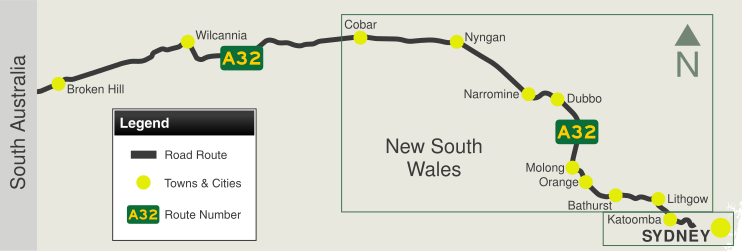
- Suburbs, Towns &
Localities Along The Route: Glenbrook, Blaxland, Warrimoo,
Valley Heights, Springwood, Faulconbridge, Linden, Woodford, Hazelbrook,
Lawson, Bullaburra, Wentworth Falls, Leura, Katoomba, Medlow Bath,
Blackheath, Mt Victoria, Hartley, Bowenfels, Lithgow, Marrangaroo, Mt
Lambie, Meadow Flat, Yetholme, Glanmire, Raglan, Kelso, Bathurst,
Dunkeld, Vittoria, Guyong, Lucknow, Orange, Molong, Wellington, Geurie,
Wongarbon, Dubbo, Narromine, Trangie, Nevertire, Nyngan, Cobar,
Wilcannia, Broken Hill and Cockburn
Route Numbering:
- Former:

- Road Authority
Internal Classification: HW5 (Glenbrook to Bathurst), HW7
(Bathurst to Nyngan) and HW8 (Nyngan to South Australia) 1
General Information:
National Route 32 is the main route linking the New
South Wales state capital, Sydney, with the west of the state. The road
varies from arterial road conditions, rural expressway and rural highway.
The highway is signposted as A32 from
Glenbrook in Sydney's west, to its terminus at Bathurst. Great Western
Hwy is signposted as A44 in the sydney area.
The Great Western Highway is regarded as one
of the oldest roads in Australia. Starting as George Street in the
Sydney CBD, and following Parramatta Road, it heads west across
metropolitan Sydney to Penrith, where it crosses the Nepean River. It
then crosses the Blue Mountains and the Great Dividing Range to
Bathurst.
The road across the Blue Mountains was built by
William Cox in the 1800s shortly after a viable route across the
mountains was discovered. An obelisk at Macquarie Place in Sydney
records the construction of the road during the rule of Governor Lachlan
Macquarie.
In the 90s, the highway was terminated at Emu Plains
with the closure of the Knapsack Gully Viaduct. An extension to the
Western Mwy (M4) at Emu Plains was constructed, which rejoined with the
highway at Glenbrook. The upper portion of the Great Western Highway
from Russell Street is now only used by residents and cars coming from
Blaxland via Mitchells Pass. Mitchells Pass is section of the former
main road over the Blue Mountains.
The Mitchell Highway links north-western NSW
with Dubbo, Bathurst and eventually Sydney.
The highway starts at Bathurst as A32 and heads west
through the Great Dividing Range to Orange then continues north through
Molong, Wellington and Dubbo. From Dubbo, the highway follows the Bourke
railway line in a north-westerly direction to Nyngan. The highway's
route number changes to B71 (after the Barrier Highway junction at
Nyngan), and then it continues north-west to Bourke and terminates at
the QLD border, just north of Barringun.
The Mitchell Highway is named after Major Thomas
Mitchell, who was Surveyor-General of New South Wales in the 1820s and
explored much of inland New South Wales and Victoria.
The Barrier Highway is a highway in New South
Wales and South Australia.
The Barrier Highway starts at Nyngan where it joins
the Mitchell Highway. It heads west to Cobar. It then continues to
Wilcannia, then further west it passes through Broken Hill and enters
South Australia, turning southwest towards Adelaide. It joins Main North
Road at Giles Corner between Riverton and Tarlee. Route A32 continues on
Main North Road to Gawler where it joins the Sturt
Highway (A20). The area traversed by the Barrier Highway is remote
and very sparsely settled.
History:
- May 1813: Successful crossing of the Blue Mountains
by Gregory Blaxland, William Charles Wentworth and Lieutennant William
Lawson. 2
- 18 July 1814: Work commences from Emu Plains (Emu
Ford) on what eventually becomes Great Western Road. The Chief
Magistrate at Windsor, William Cox supervised the construction of what
was the first road over the Blue Mountains. 2
- 7 November 1814: Construction of mountain pass at Mt
York. 2
- 6 December 1814: Work begins on 1 bridge over the
Lett River and another over the Cox River. the were completed in 6 days.
2
- 15 December 1814: Completion of the mountain pass at
Mt York. 2
- 14 January 1815: Completion of a 12 feet wide 101
mile track to Bathurst. 2
- 1829: Work begins on Victoria Pass. 2
- 23 October 1832: Victoria Pass is opened by Governor
Bourke. 2
- 1832: Construction begins on Lennox Bridge, over
Lapstone Creek, along what is known as Mitchell's Pass. 2
- 1833: Completion of Lennox Bridge. 2
- 22 March 1834: Completion of Mitchells Pass. 2
- June 1858: The Main Roads Management Act appoints
Captain BH Martindale as the person responsible for the management of 3
main roads in the colony including the Great Western Road, from Sydney
via Parramatta, Penrith, Hartley and Bathurst to Wellington. 2
- 1896: Western Road extended to reach Warren, now
located on Oxley Highway. 2
- 7 June 1926: A board meeting resolved to set aside
funding from the Commonwealth's road funding scheme for road development
to be used on some of NSW 'great trunk routes', which included the Great
Western Road. 2
- 1932: Construction of the Cox's River Deviation. 2
- 1938: Installation of warning signs, roadmarkings and
guide posts along a 60 mile stretch between Parramatta and Mt Victoria.
These were implemented for testing, for a possible statewide rollout. 2 Construction of railway overpass on the
Mitchell Hwy at Molong. 3
- 1939: After successful testing of warning signs,
roadmarkings and guide posts, the system was implemented statewide. Also
completion of pavement along the Great Western Road. 44% or 120 miles of
Mitchell Hwy paved with bitumen surface. 2
- 1950s: Completion of a ¾ mile section of highway
constructed between Linden and Woodford to bypass 2 badly aligned
railway bridges, which were the site of several bad crashes. Also the
bypassing of the railway level crossing at Katoomba. A 1 mile long
deviation and a new overbridge over the railway line to eliminate sharp
approaches to the previous bridge. The Forty Bends section of the
highway near Lithgow was also eliminated. 2
- 1953: Reconstruction program commences of the Barrier
Hwy. 2
- 1960: Dust-free road surface completed along Mitchell
Hwy between Bathurst and Dubbo. 2
- 26 September 1969: Opening of the 2013 feet long 28
span prestressed concrete bridge over the Macquarie River at Dubbo. At
the time it was the fourth longest bridge in the state. 2
- 1970s: Bitumous sealing of the Barrier Highway
completed. 2
- 6 November 1972: Completion of bitumous sealing along
Mitchell Highway. 2
- 1980s: Great Western Hwy widened from 4 lanes to 6
lanes between St Marys and Werrington, and also between Blacktown and
Prospect. Also Great Western Highway re-routed away from High St in
Penrith after the opening of a pedestrian mall along High St. Also
widening works at various locations between Blaxland and Katoomba.
- 6 January 1989: Bridge over Macquarie River at Wellington collapsed into the river after a collision on the bridge involving a truck carrying heavy excavation equipment. 4
- 1990s: Great Western Hwy truncated at Russell St in
Emu Plains when the Western Mwy (M4) was extended up into the Blue
Mountains.
- December 1991: New bridge over Macquarie River at Wellington opened to traffic. 4
- July 2000: New pedestrian bridge constructed on Great
Western Hwy at Valley Heights. 5
- July 2000: Four lane upgrade and construction of a
pedestrian bridge at railway station on Great Western Hwy at Warrimoo. 4
- February 2001: Parking improvements and construction
of a pedestrian bridge at railway station on Great Western Hwy at
Blaxland. 5
- June 2001: Four lane upgrade and construction of
pedestrian bridge at railway station on Great Western Hwy at
Faulconbridge. 5
- June 2002: Improved alignment and overtaking lane
constructed on Great Western Hwy at Soldiers Pinch at Mount Victoria. 4
- 2003: Two overtaking lanes built on the Mitchell
Highway between Dubbo and Wellington. Reconstruction and widening of the
highway including intersection improvements at the Milthorpe Road
intersection at Vittoria. Reconstruction and widening of the highway
including sealing road shoulders and line marking at Narromine. 11 km of
widening works 70 km west of Cobar on Barrier Hwy. 6
- August 2003: Four lane upgrade with new bridges and
pedestrian signals constructed on Great Western Hwy at Linden. 5
- December 2003: Improved alignment, replacement bridge
and new signalised intersection on Great Western Hwy at Medlow Bath. 4
- August 2004: Four lane upgrade, two new bridges, new
traffic signals on a new alignment bypassing Shell Corner on Great
Western Hwy at Katoomba. 5
- June 2005: Four lane upgrade with three improved
intersections and new off-road shared pedestrian/cyclist path on Great
Western Hwy at Wentworth Falls. 5
- August 2005: Median barrier extended and wider
shoulder for cyclists on Great Western Hwy along Lapstone Hill near
Glenbrook. 5
- May 2006: Four lane upgrade on Great Western Hwy
from Willow Park Avenue, Leura to Bowling Green Avenue, Katoomba. March
2009: Four lane upgrade on Great Western Hwy from Kings Road and Bowling
Green Avenue at Katoomba. 5
- August 2008: Works begin on widening Great Western
Hwy at Lawson. 6
- October 2009: Construction begins on replacement
bridge over the railway line on the Mitchell Hwy at Molong. 8
- 8 June 2010: Installation begins of pedestrian
signals on Great Western Hwy at Blackheath. 9
- 2011: Rest area upgrades on the Mitchell Hwy at
Gamboola, Two Mile Creek, Larras Lee and Nevertire. 10
Upgrade and widening works begin on the Great Western Highway Upgrade
between Station Street,Woodford and Winbourne Road, Hazelbrook. 11
1 Roads and
Traffic Authority, Schedule of Classified Roads (and unclassified Regional
Roads), 25 February 2008
2 Department of Main Roads. The
Roadmakers, A History of Main Roads in New South Wales, ISBN 0 7240 0439 4
3 Roads & Traffic Authority,
Projects, Western Region, Completed Projects, Railway
overpass at Molong.
4 ABC Western Plains, 30 Years Since Wellington Bridge Collapse, 6 January 2019
5 Roads & Traffic Authority,
Projects, Great Western Highway, Completed
projects.
6 Roads & Traffic Authority,
Community update, Road
activity update – Western NSW, February 2003.
7 Roads & Traffic Authority, News
& Events, Great
Western Highway upgrade at Lawson, 4 August 2008.
8 Minister for Infrastructure &
Transport, Media Release, Molong
overpass construction underway, October 14 2009.
9 Roads & Traffic Authority,
Projects, Great Western Highway, Installation
of mid-block pedestrian lights – Great Western Highway, Blackheath,
31 May 2010.
10 Roads & Traffic Authority, Projects
approved under Round 2 of the Federal Government's Heavy Vehicle Safety
Productivity Program, March 2010.
11 Roads & Traffic Authority,
Projects,
Great Western Highway, July 2011.
Last updated: 05-Jul-2020 11:43
This site ©
Paul
Rands. All rights reserved. Some portions © (copyright) by their
respective and credited owners. Permission must be obtained before using
any images from this site. For details, please email by clicking
here.