|
|
|
|
|
 |
Bay Street, Crockford Street, City Road, Montague Street, Wurundjeri Way, Flinders Street, Wellington Parade, Bridge Road, Burwood Road and Camberwell Road (Metropolitan Route 30) |
Statistics:
Route Numbering:


General Information:
Metropolitan Route 30 is an arterial route that connects Port Melbourne with Camberwell via the Melbourne CBD and Hawthorn. It varies from divided and undivided road and also features tram lines along it between Docklands and Hawthorn as well as through Camberwell.
Multiplexes along the route include:
History:

| Camberwell to Port Melbourne | Port Melbourne to Camberwell | |||
| Preview: | Description: | Preview: | Description: | |
 |
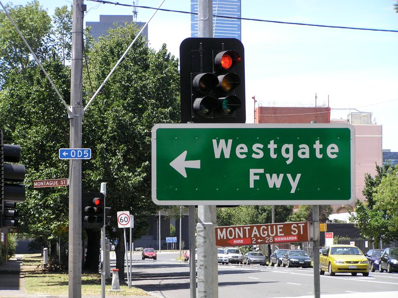
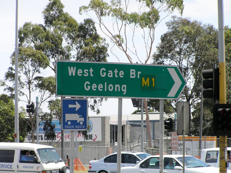
Advance Directional Signs: Freeway green AD signs in Docklands approaching West Gate Fwy (M1 / TD2), November 2005. Image © Rob Tilley |
 |
Advance Directional Sign & Trailblazers: AD sign on Normanby Rd (former MR30) in South Melbourne approaching Montague St (MR30), November 2005. The MR20 routing has since been removed. The AD sign should probably have 'To' prefixed to it as well. Image © Rob Tilley |
|
 |
Advance Directional Sign: AD sign on the off ramp from West Gate Fwy (M1) onto Montague St (MR30), November 2005. Note the freeway green panel and missing coverplates. Image © Rob Tilley |
 |
Intersection Directional Sign: ID sign on the corner of Normanby Rd and Montague St (MR30) in South Melbourne, November 2005. The sign should probably have 'To' prefixed to it. Image © Rob Tilley |
|
 |
Intersection Directional Sign: ID sign at the Montague St (MR30) & West Gate Fwy (M1) interchange in Docklands, November 2005. Image © Rob Tilley |
 |
Trailblazers: MR2 and MR30 trailblazers at South Melbourne, November 2005. MR2 has long been decommissioned. Image © Rob Tilley |
|
 |
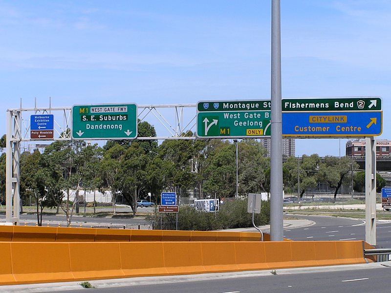
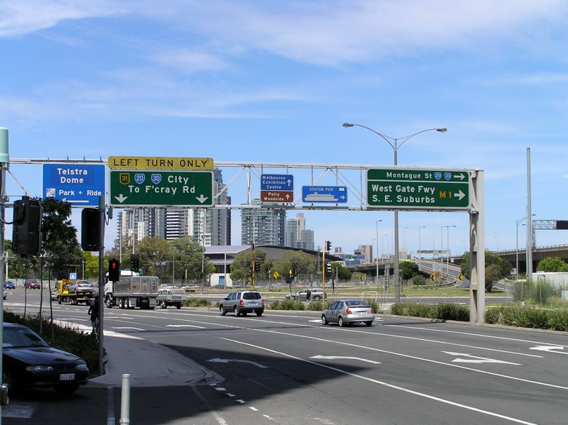
Westgate Freeway Interchange: The interchange with Westgate Fwy (M1) in Docklands, November 2005. Image © Rob Tilley |
 |
Black & Freeway Green Advance Directional Sign: Black and freeway green AD sign at South Melbourne appoaching West Gate Fwy (M1), November 2005. The MR20 routing has since been removed. Image © Rob Tilley |
|
 |
Westgate Freeway Interchange: ID sign at the interchange with Westgate Fwy (M1) in Docklands, November 2005. Image © Rob Tilley |
 |
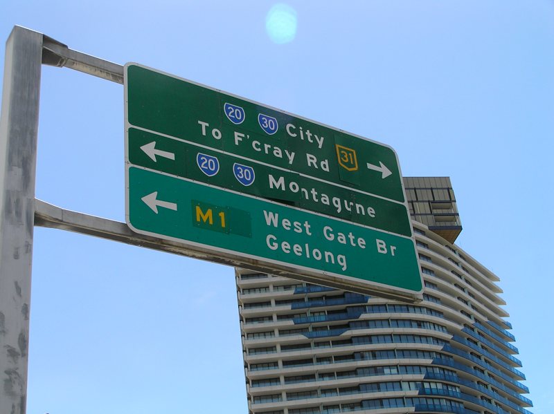
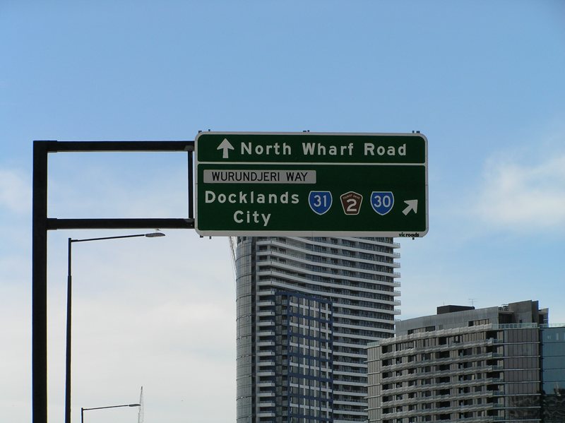
Advance Directional Sign: AD sign on Montague St (MR30) near West Gate Fwy (M1) interchange approaching Lorimer St and Wurundjeri Way (MR30 / MR55 / TD2), November 2005. Image © Rob Tilley |
|
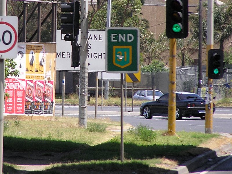 |
Old Trailblazer: Old end NH31 shield at the West Gate Fwy (M1) interchange in Docklands, November 2005. Image © Rob Tilley |
 |
Advance Directional Sign: AD sign on Montague St (MR30) near West Gate Fwy (M1) approaching Lorimer St, November 2005. Image © Rob Tilley |
|
 |
Westgate Freeway Interchange: ID signs at the interchange with Westgate Fwy (M1) in Docklands, November 2005. Image © Rob Tilley |
 |
Advance Directional Sign: AD sign showing NH31, which is now MR55. Montague St (MR30) as it passes under Westgate Fwy (M1) at South Melbourne, November 2005. Image © Rob Tilley |
|
 |
Westgate Freeway Interchange: ID sign at the interchange with Westgate Fwy (M1) in South Melbourne, November 2005. Image © Rob Tilley |
 |
Westgate Freeway Interchange: ID sign at the interchange with Westgate Fwy (M1) in Docklands, November 2005. Image © Rob Tilley |
|
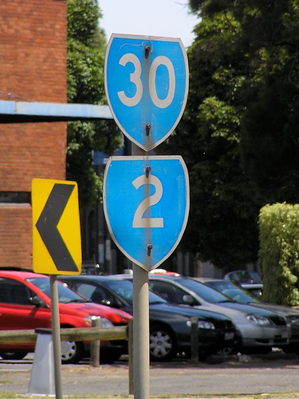 |
Trailblazers: MR2 and MR30 trailblazers at South Melbourne, November 2005. MR2 has long been decommissioned. Image © Rob Tilley |
 |
Westgate Freeway Interchange: ID sign at the interchange with Westgate Fwy (M1) in Docklands, November 2005. Image © Rob Tilley |
|
 |
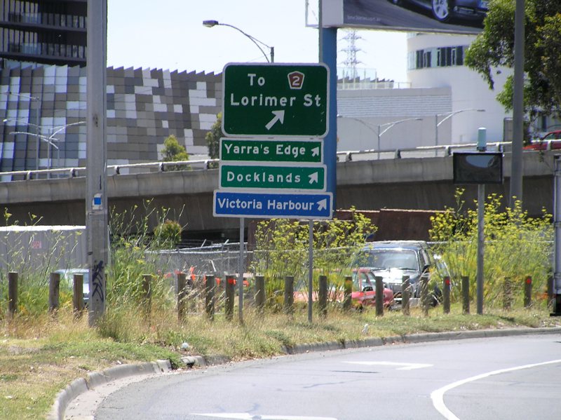
Intersection Directional Sign: ID sign assembly at the Lorimer St junction in Docklands, November 2005. Image © Rob Tilley |
|||
 |
Lorimer Street: Advance directional sign gantry on Lorimer St in Docklands, November 2005. Wurundjeri Way (MR30 / MR55 / TD2) is to the left and Montague St (MR30) is to the right. Note the old NH31 shield. Image © Rob Tilley |
|||
 |
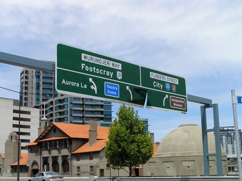
Advance Directional Sign: AD sign on Wurundjeri Way (MR30 / MR55 / TD2) in Docklands approaching Harbour Esp, November 2005. Note the erroneous MR31 shield. Image © Rob Tilley |
|||
 |
Advance Directional Sign: AD sign on Wurundjeri Way (MR30 / MR55 / TD2) approaching Flinders St (MR30 / TD2) at Docklands, November 2005. Note the erroneous NR31 shield. Image © Rob Tilley |
|||
1 Viseth Uch
2 Minister for Major Projects & Tourism, Media Release, Docklands' North / South Road Named, 6 June 2000.
3 Minister for Public Transport, Media Release, $80 000 Safety Improvements for Burwood Road Black Spot, 7 December 2004
Last updated: 17-Dec-2019 0:55
This site © Paul Rands. All rights reserved. Some portions © (copyright) by their respective and credited owners. Permission must be obtained before using any images from this site. For details, please email by clicking here.