|
|
|
|
|

|
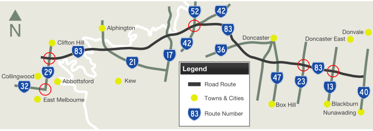
Eastern Freeway & Eastlink (Metropolitan Route 83) (Decommissioned) - Collingwood to Nunawading |
Statistics:
Route Numbering:

General Information:
When Eastlink opened in June 2008, VicRoads, the body responsible for Victoria's major road network, decommissioned Metropolitan Route 83 from the Eastern Freeway, which runs from Collingwood to Nunawading. The number M3 was implemented along the full length of both the Eastern Freeway and Eastlink.
Eastern Freeway:
The Eastern Freeway was originally meant to receive the F19 route number. 2
In the 1970s when the Eastern Freeway was built, the design included provision for rail. Some tunnelling construction work was, in fact, started in the 1970s, near Hoddle Street. Overpasses were also built to cater for rail. 3
History:
| Collingwood to Nunawading | Nunawading to Collingwood | |||
| Preview: | Description: | Preview: | Description: | |

|
Freeway Green Supplemental AD Sign: Freeway green supplemental advance directional sign approaching Burke Road (MR17) at Kew East, November 2005. Image © Rob Tilley |

|
Supplemental AD Sign: Supplemental advance directional sign approaching Middleborough Road (MR23) at Blackburn North, November 2005. Image © Rob Tilley |
|

|
Burke Road Interchange: Westbound at Kew East at the Burke Rd (MR17) interchange, November 2005. Image © Rob Tilley |

|
Supplemental AD sign: Supplemental advance directional sign approaching Tram Road (MR47) at Blackburn North, November 2005. Image © Rob Tilley |
|

|
Advance Directional Sign: AD sign on the off-ramp at Burke Rd (MR17) interchange at Kew East, November 2005. Image © Rob Tilley |

|
Tram Road Interchange: Eastern Fwy citybound, at Tram Road interchange in Blackburn North, November 2005. Image © Rob Tilley |
|
|
Advance Directional Sign: AD sign for Bulleen Road (MR42/52) at the Burke Road (MR17) interchange at Kew East, November 2005. Image © Rob Tilley |

|
Advance Directional Sign: AD sign on the off-ramp at the Tram Road (MR47) interchange in Blackburn North, November 2005. Image © Rob Tilley |
|
 |
Advance Directional Sign: AD sign at Bulleen approaching Doncaster Rd (MR36), November 2005. Image © Rob Tilley |

|
Advance Directional Sign: AD sign on the Elgar Road overpass at Doncaster, November 2005. Image © Rob Tilley |
|
 |
Elgar Road Interchange: Elgar Rd interchange at Doncaster, November 2005. Image © Rob Tilley |

|
Variable Message Sign: VMS sign in Doncaster indicating traffic density and travel time to selected exits along the route, November 2005. Image © Rob Tilley |
|
 |
Advance Directional Sign: AD sign at Doncaster approaching Middleborough Rd (MR23), November 2005. Image © Rob Tilley |

|
Supplemental AD Sign: Supplemental advance directional sign at Doncaster approaching Doncaster Road (MR36), November 2005. Image © Rob Tilley |
|
 |
Middleborough Road Interchange: Middleborough Rd (MR21) interchange in Blackburn North, November 2005. Image © Rob Tilley |
|
Sound Barrier: Unusual sound walls approaching Doncaster Road (MR36) in Balwyn North, November 2005. Image © Rob Tilley |
|
 |
Blackburn Road Interchange: The Blackburn Road (MR13) interchange at Doncaster East, November 2005. This is where the Eastern Freeway merges down to 3 lanes each way. Image © Rob Tilley |

|
Doncaster North Interchange: Eastern Fwy (former MR83) at Balwyn North at the Doncaster Rd (MR36) interchange, November 2005. Image © Rob Tilley |
|
 |
End Freeway 1km: End Freeway sign at Doncaster East, November 2005. Image © Rob Tilley |

|
Advance Directional Sign: AD sign on the off-ramp to Doncaster Road (MR36) at Balwyn North, November 2005. Image © Rob Tilley |
|

|
Supplemental AD Sign: Supplemental advance directional sign approaching Bulleen Road (MR42/52) at Balwyn North, November 2005. Image © Rob Tilley |
|||

|
Variable Message Sign: VMS sign in Balwyn North indicating traffic density and travel time to the Hoddle Street junction at the end of the freeway, November 2005. Image © Rob Tilley |
|||
 |
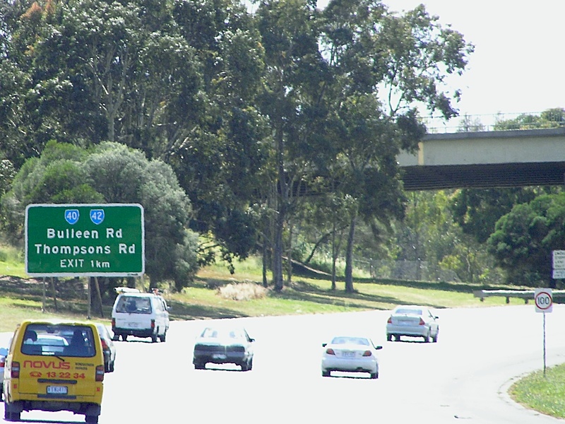
Advance Directional Sign: AD sign on the off ramp to Bulleen Rd (MR40 / SR42) at Balwyn North, November 2005. Image © Rob Tilley |
|||
 |
Intersection Directional Sign: ID sign on the off ramp to Bulleen Rd (MR40 / SR42) at Balwyn North, November 2005. Image © Rob Tilley |
|||

|
Freeway Green Advance Directional Sign: Freeway green AD sign approaching Chandler Hwy (MR21) at Kew, November 2005. Image © Rob Tilley |
|||

|
Freeway Green Supplemental AD Sign: Freeway green supplemental AD sign approaching Chandler Hwy (MR21) at Kew, November 2005. Image © Rob Tilley |
|||

|
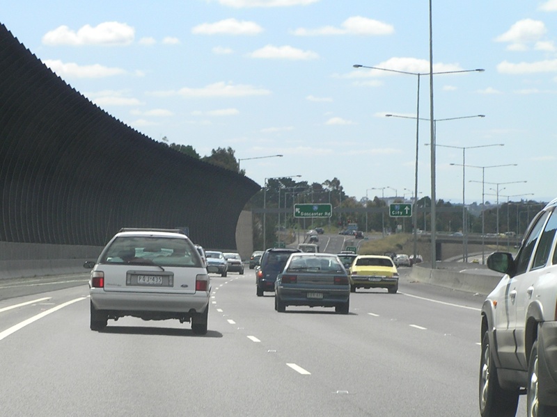
Chandler Highway Interchange: Eastern Fwy at Chandler Hwy (MR21) at Kew, November 2005. Image © Rob Tilley |
|||

|
Advance Directional Sign: AD sign at Fairfield for the junction with Hoddle St (MR29), November 2005. Image © Rob Tilley |
|||

|
Freeway Green Directional Signs: Freeway green directional signage over the lanes of the Eastern Fwy at Fairlfield approaching the end of the freeway, November 2005. Image © Rob Tilley |
|||

|
End Freeway 1km: End Freeway sign at Fairfield, November 2005. Image © Rob Tilley |
|||

|
Freeway Green Directional Signs: Freeway green directional signage over the lanes of the Eastern Fwy at Abbottsford approaching the end of the freeway, November 2005. Image © Rob Tilley |
|||

|
Hoddle Street Interchange: Last interchange, westbound on the Eastern Freeway in Abbottsford, November 2005. Image © Rob Tilley |
|||
1 VicRoads Road Management Plan, 30
October 2004
2 Picture Victoria, 1970s Anti-freeway protest
3 Victorian Competition & Efficiency Commission, Inquiry Into Managing Transport Congestion
4 Tim Cole
5 Picture Australia, 1970s Freeway construction
6 Victorian Auditor General's Office, Road construction in Victoria: Major projects managed by VicRoads
7 Department of Infrastructure, Annual Report 1997-98
8 Office of the Minister for Roads and Ports, Media Release, $255 Million to Extend Eastern Freeway to Ringwood, $175 Million for new Hallam Bypass, 4 May 1999
9 Minister of Transport, Media Release, First Eastern Freeway Milestone is Reached, 22 February 2001
10 The Office of the Premier, Media Release, Premier Announces $326m Eastern Fwy Extension, 13 October 2000
11 Minister of Transport, Media Release, Park Road Bridge Over Eastern Freeway Extension Opened to Traffic, 26 March 2002
12 Minister of Transport, Media Release, Bracks Government Announces Mitcham-Frankston Freeway Project, 23 September 2002
Last updated: 14-Feb-2019 20:53
This site © Paul Rands. All rights reserved. Some portions © (copyright) by their respective and credited owners. Permission must be obtained before using any images from this site. For details, please email by clicking here.