|
|
|
|
|
| C221 | Pomonal Road, Stawell-Avoca Road, Ararat-St Arnaud Road & Moonambel Road (C221) |
Statistics:
Route Numbering:
General Information:
C221 is a rural connector route in Western Victoria, connecting the Sunraysia Highway (B220) north of Avoca at Tanwood to the medium sized town of Stawell and then eventually to the Grampians National Park.
Multiplexes along the route include:

| Pomonal To Tanwood | Tanwood To Pomonal | |||
| Preview: | Description: | Preview: | Description: | |
 |
Reassurance Directional Sign: RD sign on Stawell-Avoca Rd (Seaby St) after the intersection with Western Hwy in Stawell, September 2009. Image © Rob Tilley |
 |
Intersection Directional Sign: ID sign assembly facing Patrick St (C238) at Stawell, November 2012. Image © Rob Tilley |
|
 |
Advance
Directional Sign: AD sign on Scallan Street approaching the intersection with Main and Barnes Streets in Stawell, December 2006. Image © Rob Tilley |
|||
 |
Intersection Directional Sign: ID sign at the Barnes Street roundabout in Stawell, December 2006. Image © Rob Tilley |
|||
 |
Advance
Directional Sign: AD sign on Seaby St approaching Western Hwy (NH-A8) at Stawell, December 2006. Image © Rob Tilley |
|||
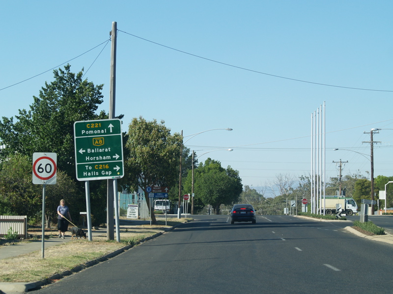
 |
Intersection
Directional Sign: ID sign facing traffic travelling southwest on Seaby Street, on the corner Western Hwy (NH-A8) and Pomonal Road (C221) in Stawell, December 2006. Image © Rob Tilley |
|||
1 Vicroads Road Management Plan, October 2004
Last updated: 12-Feb-2019 5:10
This site © Paul Rands. All rights reserved. Some portions © (copyright) by their respective and credited owners. Permission must be obtained before using any images from this site. For details, please email by clicking here.