|
|
|
|
|
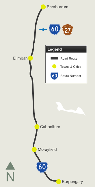
| Uhlmann Road, Morayfield Road and Beerburrum Road (State Route 60) |
Statistics:
Route Numbering:


General Information:
State Route 60 is the former Bruce Highway alignment between Beerburrum and Burpengary.
The route varies from rural highway standard to
multi-laned divided suburban arterial road standard and caters to local
traffic, leaving the Bruce Hwy (M1) for through traffic.
SR60 passes through residential, commercial,
industrial, semi-rural and bushland areas.
Multiplexes along the route include:
History:
| Beerburrum to Burpengary | Burpengary to Beerburrum | |||
| Preview: | Description: | Preview: | Description: | |
 |
Intersection
Directional Sign: ID sign at the corner of Beerburrum Rd (SR60), Old Gympie Rd and Industry Dr at Caboolture, November 2009. Image © Rob Tilley |
 |
Bruce
Highway Interchange: Sign facing the southbound off ramps from Bruce Hwy (M1) at the junction with Uhlmann Rd (SR60), August 2009. SR60 only travels right from this junction. Image © Rob Tilley |
|
 |
Advance
Directional Sign: AD sign on Beerburrum Rd (SR60) approaching Pumicestone Rd at Caboolture, November 2009. The SR85 shield should be prefixed with 'to' as SR85 is not routed along Beerburrum Rd. Image © Rob Tilley |
|||
 |
Advance
Directional Sign: AD sign approaching Industry Dr and Old Gympie Rd at Caboolture, November 2009. SR85 is no longer routed along Old Gympie Rd since the opening of the Caboolture Bypass, and merely acts as access to the D'Aguilar Hwy (SR85) and Caboolture Bypass (SR85), and to several small towns nearby. Image © Rob Tilley |
|||
 |
Intersection
Directional Sign: ID sign at the corner of Beerburrum Rd (SR60), Old Gympie Rd and Industry Dr at Caboolture, November 2009. Image © Rob Tilley |
|||
 |
Intersection
Directional Sign: ID sign at the corner of Beerburrum Rd (SR60), Old Gympie Rd and Industry Dr at Caboolture, November 2009. Image © Rob Tilley |
|||
1
Transport & Main Roads, Queensland state-controlled roads and
region maps, North Coast Region: back
2 Queensland Government,
Ministerial Media
Statements, New names revealed for north coast bridges, 4
September 2009.
3 Queensland Government,
Ministerial Media
Statements, New concrete bridge for Six Mile Creek, 30 June
2011
4 Queensland Government,
Ministerial Media
Statements, Green light for $153 million Morayfield Road upgrade,
15 December 2011
Last updated: 17-Dec-2019 0:55
This site © Paul Rands. All rights reserved. Some portions © (copyright) by their respective and credited owners. Permission must be obtained before using any images from this site. For details, please email by clicking here.