|
|
|
|
|
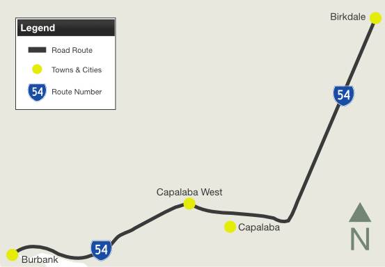
| Mt Gravatt-Capalaba Road, Old Cleveland Road East & Birkdale Road (State Route 54) |
Statistics:
Route Numbering:
General Information:
State Route 54 is a connector route in Brisbane's
bayside area.
The route is divided between Capalaba and Birkdale,
but rural road standard between Burbank and Capalaba. The route passes
through bushland, semi-rural, commercial and residential areas.
| Preview: | Description: |
 |
Reassurance
Directional Sign: Distance sign with missing SR54 shield along Birkdale Rd (SR54) at Birkdale, July 2011. Image © Rob Tilley |
 |
Advance
Directional Sign: AD sign approaching Quarry Rd (SR43) and Birkdale Rd (SR43) at Birkdale, July 2011. SR54 ends at this junction. Image © Rob Tilley |
 |
Intersection
Directional Sign: ID sign at the roundabout with Quarry Rd (SR43) and Birkdale Rd (SR43) at Birkdale, July 2011. SR54 ends at this junction. Image © Rob Tilley |
Last updated: 17-Dec-2019 0:55
This site © Paul Rands. All rights reserved. Some portions © (copyright) by their respective and credited owners. Permission must be obtained before using any images from this site. For details, please email by clicking here.