|
|
|
|
|

|
Malanda-Atherton Road, Millaa Millaa-Malanda Road & Palmerston Highway (State Route 25) |
Statistics:
Route Numbering:

General Information:
State Route 25, in far north Queensland, is a connector route linking the Atherton tablelands with the east coast town of Innisfail.
A windy undivided two-laned road, it passes through lush rainforest and semi-rural properties.
Multiplexes along the route include:
History:

| Goondi to Atherton | Atherton to Goondi | |||
| Preview: | Description: | Preview: | Description: | |
 |
Intersection Directional Sign: ID sign assembly on Bruce Hwy (A1) at the Palmerston Hwy (SR25) junction at Goondi, May 2005. Image © Rob Tilley |
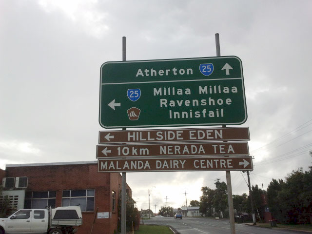 |
Advance Directional Sign: AD sign on Malanda-Lake Barrine Rd (James St) at Malanda, May 2013. Image © Terry Siva |
|
 |
Distance Sign: RD sign after leaving Malanda on Millaa Millaa-Malanda Rd (SR25), May 2005. Image © Rob Tilley |
|||
 |
Distance Sign: Reassurance directional sign near Millaa Millaa, May 2005. Image © Rob Tilley |
|||
 |
Reassurance Directional Sign: Distance sign at Millaa Millaa, April 2013. Image © Terry Siva |
|||
 |
Steep Descent Warning Sign: Sign warning of steep grades as Palmerston Hwy (SR25) descends the mountain at Mungali, May 2005. Image © Rob Tilley |
|||
 |
Advance Directional Sign: AD sign on Palmerston Hwy (SR25) approaching Bruce Hwy (A1) at Goondi, May 2005. This photo pre-dates the introduction of A1 along Bruce Hwy. Image © Rob Tilley |
|||
1 Department of Transport and Main Roads, Queensland State Controlled Roads and Regions Maps, Far North Region: front
2 Great Tropical Drive - A New Discovery Around Every Corner brochure, 23 April 2009
3 Queensland Government, Media Statements, Safety Upgrade for East Evelyn Intersection, 21 October 2010
Last updated: 20:43:27 2/7/2016.
This site © Paul Rands. All rights reserved. Some portions © (copyright) by their respective and credited owners. Permission must be obtained before using any images from this site. For details, please email by clicking here.