|
|
|
|
|
 |
Capricorn Highway (National Route 66) |
Statistics:
Route Numbering:


General Information:
Capricorn Highway is an important route in the Queensland highway system, linking farming and mining interests of Central Queensland with the coast and Bruce Highway at Rockhampton.
Tracing the Tropic of Capricorn and crossing the Great Dividing Range, the route is rural highway standard, consisting mostly of 1 lane in each direction, and services residential, rural and industrial areas.
Multiplexes along the route include:
History:

| Preview: | Description: |
 |
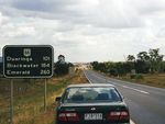
Black Reassurance Directional Sign: Old black distance sign with unusual font, Gracemere, 1999. Image © Jamie Scuglia |
1 Queensland Government, Transport and Main Roads, Road Classification Map, Fitzroy Region, September 2011
2 Queensland Government, Transport and Main Roads, Road Classification Map, Central West Region, September 2011
3 Michael Greenslade
Last updated: 30-Mar-2019 10:37
This site © Paul Rands. All rights reserved. Some portions © (copyright) by their respective and credited owners. Permission must be obtained before using any images from this site. For details, please email by clicking here.