|
|
|
|
|
| A55 | Castlereagh Highway & Carnarvon Highway (A55) |
Statistics:
Route Numbering:


General Information:
A55 is a rural highway in the southern central west of Queensland. It's a mostly single carriageway route.
Multiplexes along the route include:
History:

| St George to Roma | Roma to St George | |||
| Preview: | Description: | Preview: | Description: | |
 |
Welcome
to Queensland: Tourism Queensland sign welcoming motorists to Queensland, as the Castlereagh Hwy crosses the border from NSW. It's here the route number changes from B55 (used in NSW) to A55 (used in QLD). October 2005. Image © Paul Rands |
|
 |
Intersection
Directional Sign: ID sign at the corner of Burrowes St and Cordelia St at Surat, August 2014. Image © Ed Huang |
 |
State
Speed Limits Sign: Sign indicating the maximum speed limits used in QLD, as you cross the border from NSW at Hebel, October 2005. Image © Paul Rands |
|
 |
Reassurance
Directional Sign: RD sign after the Moonie Hwy (SR49) intersection at St George, October 2005. This sign should also show theSR49 duplex between here and the St George CBD. Image © Paul Rands |
 |
Services
Sign: Services sign indicating tourist information details, Hebel, October 2005. Image © Paul Rands |
|
 |
Intersection
Directional Sign: ID sign on the corner Balonne Hwy (SR49) (Victoria St) and Grey St in St George, October 2005. Image © Paul Rands |
 |
Dust
Sign: Regulatory sign indicating heavy vehicles are to stop outside of the town centre to allow dust to fall from their vehicles before entering. Hebel, October 2005. Image © Paul Rands |
|
 |
Distance
Sign: RD sign on Grey St (Carnarvon Hwy) in St George, after the Balonne Hwy (SR49) intersection. October 2005. Image © Paul Rands |
 |
Dust
Drop Bay: Bay for heavy vehicles to drop dust before entering Hebel. October 2005. Image © Paul Rands |
|
 |
Intersection
Directional Sign: ID sign at the corner of Carnarvon Hwy (NR46) and Castlereagh Hwy (A55) southeast of St George, October 2005. Image © Paul Rands |
 |
Entering
Hebel: Entering the village of Hebel, October 2005. Image © Paul Rands |
|
 |
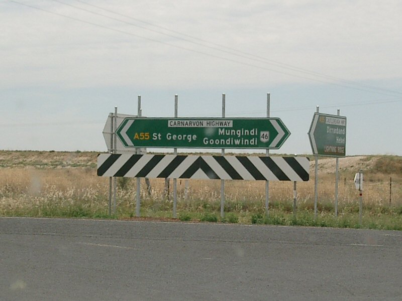
Intersection
Directional Sign: ID sign assembly at the corner of Carnarvon Hwy (NR46) and Castlereagh Hwy (A55) southeast of St George, August 2014. Image © Ed Huang |
 |
Fingerboard
Assembly: Fingerboards at the intersection with Margaret and William Streets in Hebel, October 2005. Image © Paul Rands |
|
|
|
 |
Intersection
Directional Sign: ID sign at the junction with Margaret and William Streets in Hebel, October 2005. Image © Paul Rands |
|
|
|
 |
Distance
Sign: RD sign as you leave Hebel, October 2005. Image © Paul Rands |
|
|
|
 |
Advance
Directional Sign: AD sign approaching the intersection with Dirranbandi-Bollon Rd at Dirranbandi. A55 turns right at this junction. October 2005. Image © Paul Rands |
|
|
|
 |
Intersection
Directional Sign: ID sign at the intersection with Dirranbandi-Bollon Rd at Dirranbandi. A55 turns right at this junction. October 2005. Image © Paul Rands |
|
|
|
 |
Intersection
Directional Sign ID sign in the Dirranbandi town centre as A55 makes its way onto Railway Street, October 2005. Image © Paul Rands |
|
|
|
 |
Dirranbandi
Town Centre: Looking east through Dirranbandi, October 2005. Image © Paul Rands |
|
|
|
 |
Distance
Sign: Reassurance directional sign as you leave Dirranbandi, October 2005. Image © Paul Rands |
|
|
|
 |
Intersection
Directional Sign: ID sign facing Castlereagh Hwy traffic at St George. A55 turns left here and becomes Carnarvon Hwy. October 2005. Image © Paul Rands |
|
|
|
 |
Distance
Sign: RD sign after the Castlereagh Hwy / Carnarvon Hwy (NR46) intersection at St George. October 2005. Image © Paul Rands |
|
|
|
 |
Entering
St George: Council welcome sign as you enter St George, October 2005. Image © Paul Rands |
|
|
|
 |
AD sign: Advance directional sign on Grey St (A55) approaching Balonne Hwy (SR49) intersection. A55 turns right at this intersection onto Victoria St, and picks up the duplex with SR49 for about 10 km. St George, October 2005. Image © Paul Rands |
|
|
|
 |
Distance
Sign: RD sign leaving St George near Scott Street, showing the SR49 duplex, October 2005. Image © Paul Rands |
|
|
|
 |
Distance
Sign: RD sign near St George, October 2005. Image © Paul Rands |
|
|
|
 |
Advance
Directional Sign: AD sign approaching Moonie Hwy (SR49) at St George. The SR49 duplex ends at this junction. A55 continues straight through at this junction. October 2005. Image © Paul Rands |
|
|
|
 |
Intersection
Directional Sign: ID sign at the intersection with Moonie Hwy (SR49) at St George. October 2005. Image © Paul Rands |
|
|
|
| Click here for the continuation of Castlereagh Highway as B55 in New South Wales | ||||
1 Map of the
State Road Network of Queensland, 30 June 2008
2 Balonne Shire Annual Report 2003-2004
3 Balonne Shire Annual Report 2004-2005
4 Ministerial Media Statement, More
Work for Border Transport Routes, 06 June 2006
5 Ministerial Media Statement, Widening
Works on Cararvon Highway, 16 June 2006
6 Ministerial Media Statement, New
heavy vehicle rest stops to combat driver fatigue, 26 November 2008
7 Ministerial Media Statement, Rest
area upgrades along Carnarvon Highway help truckies, 07 July 2008
8 Ministerial Regional Community Forum
Government Activities Statement (Darling Downs / Southwest Queensland), 4
December 2007 – 29 February 2008
Last updated: 03 Nov 2019 11:55
This site © Paul Rands. All rights reserved. Some portions © (copyright) by their respective and credited owners. Permission must be obtained before using any images from this site. For details, please email by clicking here.