|
|
|
|
|
 |
Hastings River Drive, Gordon Street, Lord Street, William Street, Pacific Drive & Ocean Drive (Tourist Drive 10) |
Statistics:
Route Numbering:

General Information:
Tourist Drive 10 is a coastal route linking several small coastal towns with the Pacific Hwy (NR1) on the mid north coast of New South Wales.
The section of TD10 is formed by part of the former Pacific Highway, now called Hastings River Drive, which runs from Blackmans Point to the Oxley Hwy (NR34) and Hindman St junction in the Port Macquarie CBD.

| Blackmans Point to Kew | Kew to Blackmans Point | |||
| Preview: | Description: | Preview: | Description: | |
 |
Distance Sign: Tourism based reassurance directional sign on Hastings River Rd (TD10) at Fernbank Creek, November 2010. Image © Rob Tilley |  | Black Advance Directional Sign: Black AD sign on Gordon St (TD10) approaching Horton St, Port Macquarie. The NR34 shield should be prefixed with 'To', March 2006. Image © Paul Rands |
|
 |
Entering Port Macquarie: Hastings River Dr (TD10) as it enters Port Macquarie, March 2006. Image © Paul Rands | 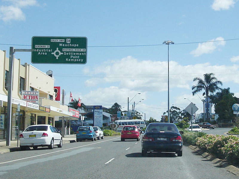 | Advance Directional Sign: AD sign on Gordon St at Port Macquarie, approaching Hindman St, Hastings River Dr (TD10)and Oxley Hwy (NR34), March 2006. Image © Paul Rands |
|
 |
Advance Directional Sign: AD sign approaching Boundary St, Port Macquarie, March 2006. Image © Paul Rands | |||
 |
Clifton Drive: Corner of Hastings River Dr (TD10) and Clifton Dr at Port Macquarie, March 2006. Image © Paul Rands | |||
 |
Black Advance Directional Sign: Black AD sign with later added coverplates, approaching Park St, Port Macquarie, March 2006. Image © Paul Rands | |||
 |
Advance Directional Sign: AD sign approaching Gordon St (TD10), Hindman St and Oxley Hwy (NR34) at Port Macquarie, March 2006. Image © Paul Rands | |||
 |
Advance Directional Sign : AD sign on Gordon St (TD10) at Port Macquarie, near Kooloonbung Ck approaching Horton St, Hay St and Lake Rd, September 2007. Image © Paul Rands | |||
1 Roads and Traffic Authority, Schedule of Classified Roads and State & Regional Roads, January 2011
Last updated: 8:44:7 31/1/2013.
This site © Paul Rands. All rights reserved. Some portions © (copyright) by their respective and credited owners. Permission must be obtained before using any images from this site. For details, please email by clicking here.