|
|
|
|
|
| Newcastle Inner City Bypass, Charlestown Road, Lookout Road, Croudace Street, Newcastle Road, Sandgate Road & Wallsend Road (State Route 123) (Decommissioned) |
Statistics:
Route Numbering:
General Information:
The Newcastle Inner City Bypass (officially known as State Highway 23) between the Pacific Highway at Bennetts Green and the Pacific Highway at Sandgate is a long standing scheme to provide an orbital road to link Newcastle’s road network.
The principal function of State Route 123 is to provide improved north - south traffic flow in the inner western suburbs of the city. The bypass provides connectivity between key destinations such as Bennetts Green, Charlestown, John Hunter Hospital, Jesmond, Newcastle University and the Pacific Highway at Sandgate.
History:
According to the Newcastle Inner City Bypass Rankin Park to Jesmond Submissions report by the Roads and Traffic Authority, the Newcastle Inner City Bypass route was first planned in the 1950s to connect the Windale/Bennetts Green area to the Pacific Highway at Sandgate. It was approved in 1957 and subsequently incorporated in the Northumberland County Planning Scheme.
The concept of the Newcastle Inner City Bypass emerged from the decision to route the Sydney to Newcastle Freeway west of Lake Macquarie in the mid 1970s. Up to that point the freeway was proposed east of Lake Macquarie and involved corridor reservations for high standard bypasses of Swansea, Belmont and Charlestown. The corridors for Swansea and Belmont have been abandoned, however the corridor from Bennetts Green to Sandgate has been maintained by the RTA to ultimately provide a bypass of inner Newcastle as State Highway No. 23.
The road corridors between Bennetts Green and Sandgate have been progressively constructed over the last 20 or so years, with the most recent construction being the West Charlestown Bypass, which is signposted as Newcastle Inner City Bypass, from Bennetts Green to Kotara Heights completed and opened to traffic on March 10, 2003, by the Minister for Roads, Carl Scully.
The section between Kotara Heights and Rankin Park was previously the subject of community debate regarding the location and standard of road to be constructed. In the late 1960s the DMR (now the RMS) proposed to construct a major elevated roadway as part of this section, which would have required a strip acquisition of Blackbutt Reserve between Carnley Avenue and McCaffrey Drive.
At the time, community concerns against the proposals effect on the environmentally sensitive Blackbutt Reserve led to the DMR working with the community to re-evaluate the proposed corridor in this section. As a result, the route through Blackbutt Reserve was abandoned and the existing Lookout Road section was widened and constructed as a four lane arterial road in lieu of freeway conditions, with at-grade intersections at Carnley Avenue, Hurn Street, Cardiff Road and Grandview Road.

| Bennetts Green to Sandgate | Sandgate to Bennetts Green | |||
| Preview: | Description: | Preview: | Description: | |
 |
Warners Bay Rd Interchange: Passing through the Warners Bay Road interchange at Mount Hutton. May 2007. Image © Paul Rands |
 |
Pacific Hwy / Wallsend Rd Intersection: Eastbound on Pacific Hwy (SR111) at Sandgate approaching Wallsend Road, May 2007. This sign has since been replaced. Image © Paul Rands |
|
 |
Distance Sign: RD sign located on the northbound carriageway of the Newcastle Inner City Bypass after the Warners Bay Road interchange at Mount Hutton. May 2007. Image © Paul Rands |
 |
Rural Drive Junction: Wallsend Road at Sandgate as you pass thru the Rural Drive junction, May 2007. Image © Paul Rands |
|
 |
AD Sign: Advance directional sign approaching the Hillsborough Rd interchange at Hillsborough. May 2007. Image © Paul Rands |
 |
Approaching Hunter Railway Line Overpass: Looking southwest on Wallsend Road at Sandgate, as you approach the overpass that crosses the Hunter Railway line, May 2007. Image © Paul Rands |
|
 |
Appraching Hillsborough Road Interchange: Northbound approaching the interchange for Hillsborough Road at Hillsborough. May 2007. Image © Paul Rands |
 |
AD Sign: Advance directional sign as you approach the turnoff to Sandgate Road and also the unnamed section of SR123, November 2010. Click here for a photo of the same location from May 2007. Image © Rob Tilley |
|
 |
Hillsborough Road Interchange: Northbound through the interchange for Hillsborough Road at Hillsborough. May 2007. Image © Paul Rands |
 |
Main Road Intersection: Intersection directional signage and the southbound ramp onto the unnamed section of SR123 at Shortland, November 2010. Image © Paul Rands |
|
 |
Myall Road Overpass: Passing under Myall Road at Garden Suburb, May 2007. Image © Paul Rands |
 |
ID Sign Assembly: Intersection directional sign on the corner of the unnamed section of SR123 and Sandgate Road at Shortland, November 2010. Click here for a photo of the same location from May 2007. Image © Rob Tilley |
|
 |
Intersection Directional Sign: ID sign at the Myall Rd interchange with Newcastle Inner City Bypass (SR123) at Kotara, November 2010. Image © Rob Tilley |
 |
Distance Sign: RD as you head southbound at Shortland on the unnamed section of SR123, just after the Sandgate Road intersection, November 2010. Image © Rob Tilley |
|
 |
Distance Sign: RD sign located on Charlestown Road at Kotara, May 2007. Image © Paul Rands |
 |
AD Sign: Southbound signage for the University Drive exit at Birmingham Gardens, November 2010. Image © Rob Tilley |
|
 |
AD Sign: Advance directional sign approaching the Carney Av intersection at Kotara. May 2007. Image © Paul Rands |
 |
Intersectional Directional Sign: ID sign at the University Dr interchange at Birmingham Gardens. Southbound, November 2010. Click here for a photo of this same location from May 2007. Image © Rob Tilley |
|
 |
Advance Directional Sign: AD sign approaching Cardiff Road at New Lambton Heights. The SR128 duplex begins from the Cardiff Road intersection, May 2007. Image © Paul Rands |
 |
Advance Directional Sign: AD sign on the off ramp to University Dr at Birmingham Gardens, November 2010. Image © Rob Tilley |
|
 |
Cardiff Road Intersection: Looking northbound at New Lambton Heights as you enter the Cardiff Rd intersection, May 2007. Image © Paul Rands |
 |
University Drive Interchange: Passing through the University Dr interchange at Birmingham Gardens. May 2007. Image © Paul Rands |
|
 |
Distance Sign: Reassurance directional sign located after the Cardiff Road intersection at New Lambton Heights, May 2007. Note the now defunct "C" Hunter Tourist Drive shield. Image © Paul Rands |
 |
Approaching Newcastle Road: Southbound on the unnamed section of SR123 at Jesmond approaching the roundabout with Newcastle Road, November 2010. Image © Rob Tilley |
|
 |
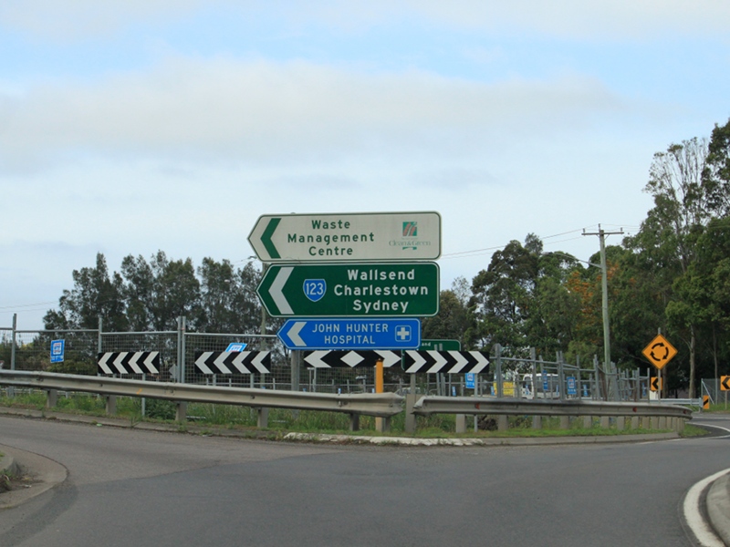
Advance Directional Sign: Northbound carriageway on Lookout Road at New Lambton Heights approaching the John Hunter Hospital intersection, May 2007. Image © Paul Rands |
 |
Supplemental Advance Directional Sign: Supplemental AD sign approaching Newcastle Rd in North Lambton, November 2010. SR123 turns left at this junction. Image © Rob Tilley |
|
 |
Intersection Directional Sign: ID sign at the corner of Russell Rd, Lookout Rd (SR123) and Croudace St (SR123) at Lambton, November 2010. Image © Rob Tilley |
 |
Intersection Directional Sign: ID sign on the Newcastle Rd roundabout in North Lambton, November 2010. Image © Rob Tilley |
|
 |
AD Sign: Advance directional sign approaching Newcastle Road at Lambton, May 2007. Image © Paul Rands |
 |
Advance Directional Sign: AD sign approaching the unnumbered section of Newcastle Rd and Croudace St (SR123) at North Lambton, November 2010. Image © Rob Tilley |
|
 |
Intersection Directional Sign: ID sign at Newcastle Rd and Croudace St (SR123), North Lambton, November 2010. Image © Rob Tilley |
|||
 |
Intersection Directional Sign: ID sign at the corner of Croudace St (SR123), Lookout Rd (SR123) and Russell Rd at Lambton, November 2010. Image © Rob Tilley |
|||
 |
Entering New Lambton Heights: Lookout Rd (SR123) entering the suburb of New Lambton Heights, November 2010. Image © Rob Tilley |
|||
 |
Advance Directional Sign: AD sign approaching Kookaburra Cct at New Lambton Heights, November 2010. Image © Rob Tilley |
|||
 |
Intersection Directional Sign: ID sign at the corner of Lookout Rd (SR123) and Cardiff Rd (SR128) at New Lambton Heights, November 2010. Image © Rob Tilley |
|||
 |
Advance Directional Sign: AD sign at New Lambton Heights approaching Carnley Av and Charlestown Rd (SR123), November 2010. Image © Rob Tilley |
|||
 |
Intersection Directional Sign: ID sign at Carnley Av and Charlestown Rd (SR123), New Lambton Heights, November 2010. Image © Rob Tilley |
|||
 |
Black Intersection Directional Sign: Black ID sign at Carnley Av and Charlestown Rd (SR123), Kotara, November 2010. Image © Rob Tilley |
|||
 |
Advance Directional Sign: AD sign approaching the now unnumbered section of Charlestown Rd and Newcastle Inner City Bypass (SR123) at Kotara (this section is officially unnamed, and known internally by RMS and council as State Highway 23), November 2010. Image © Rob Tilley |
|||
 |
Intersection Directional Sign: ID sign at Charlestown Rd (former SR123) and Newcastle Inner City Bypass (SR123) at Kotara, November 2010. Image © Rob Tilley |
|||
 |
Advance Directional Sign: AD sign on the Charlestown Rd slip lane for Park Av, Kotara, November 2010. Image © Rob Tilley |
|||
 |
Intersection Directional Sign: ID sign on Charlestown Rd (former SR123) at the on ramp to Newcastle Inner City Bypass (SR123) at Kotara South, November 2010. Image © Rob Tilley |
|||
1 Roads and Traffic Authority publication, Newcastle Inner City Bypass Rankin Park to Jesmond Submissions report.
Last updated: 17-Dec-2019 0:55
This site © Paul Rands. All rights reserved. Some portions © (copyright) by their respective and credited owners. Permission must be obtained before using any images from this site. For details, please email by clicking here.