Road Photos & Information: New South Wales
 |
|
Pacific Highway, New England Highway, John Renshaw Drive, Southern Freeway, Mount Ousley Road & Princes Highway (National Route 1) (Decommissioned) - Historic Photos: Sydney to Newcastle |
Statistics:
- Length: 1149 km
- Northern section: 668 km (Sydney to Newcastle: 167 km)
- Northern Terminus:
- Northern section: Gold Coast Highway (SR2) and Tugun Bypass (M1) at Tweed Heads West
- Southern Terminus:
- Northern section: John Renshaw Drive (NH1) and New England Highway (NH15) at Beresfield
- Suburbs, Towns & Localities Along The Route:
- Northern section: North Sydney, Artarmon, Chatswood, Pymble, Wahroonga, Hornsby, Mt Colah, Berowra, Cowan, Brooklyn, Mooney Mooney, Calga, Somersby, Kariong, Gosford, Lisarow, Wyong, Doyalson, Swansea, Charlestown, and Newcastle
Route Numbering:
- Former:
- Road Authority Internal Classification: SH10 1
- Decommissioned: At varying dates as freeways were constructed between Sydney and Newcastle.
General Information:
National Route 1 forms part of the main coastal route between Victoria and Queensland. The route features a mix of rural highway, arterial and freeway design standards. The route forms part of what is collectively known as Highway 1. It is Australia's coastal highway joining all mainland's state capitals and coastal towns circumnavigating the entire Australian continent. It is also the longest numbered highway in the world, covering more than 14 500 km.
In New South Wales, National Route 1 was truncated by National Highway 1 between Beresfield and Wahroonga, by Metroad 1 between Wahroonga and Waterfall and by M1 at Tweed Heads West.
Northern Section:
The section of National Route 1 (Pacific Highway) between Sydney and Newcastle has changed many times through the 20th century. In its later form the route varies from dual carriageway arterial and highway standard, to undivided highway conditions.
The Pacific Highway traces its origins back to an early settler, George Peat, who owned the land between the Hawkesbury River and Mooney Mooney Creek. To provide access to his property, Peat began a ferry service across the Hawkesbury River in 1844 and surveyed, then constructed a road between Hornsby and Kariong in 1854. After his death in 1870, the ferry service was abandoned and the road fell into disrepair, finally closing to all traffic in 1899, following the completion of the Sydney-Newcastle railway.
Demand for a route between Sydney and Newcastle dates back to the early 20th century. When the only access was via the sea or via a long route through the town of Wiseman's Ferry. In the 1920s, the then Main Roads Board undertook a series of surveys to form an easier and more reliable route north from Sydney. In 1928 construction began on upgrading the old road and converting it to a modern standard, plus creating a new route north, utilising some of the abandoned Peat's Ferry Rd, while improving the horizontal and vertical alignments. In May 1930 the ferry service across the Hawkesbury River was re-established to service the new road until such times that a bridge became necessary. June 1930 marked the completion of the concrete surfacing.
During the time of the Hornsby to Gosford contruction, improvements were made to roads between Gosford to Newcastle as part of the link. On May 17 in 1929, the route was named as the Great Northern Highway. The work from Hornsby to Gosford cost almost £1 million, however it was money well spent, reducing the trip from Sydney to Newcastle from 9 hours to 4 ½ hours.
History:
Pacific Highway:
- 1920s: Reconstruction of Lane Cove Road (Pacific Highway) between Boundary Street, Roseville and Pearces Corner, Wahroonga was undertaken in asphaltic concrete. It was the longest length of asphaltic concrete road then constructed by a local government authority. 2 North Sydney Council paved the Lane Cove Road (now Pacific Highway) from Milson's Point to Crow's Nest, and almost on to St. Leonards railway station, in cement concrete. The Ku-ring-gai Shire Council had also constructed the Gordon Road (now Pacific Highway) from Roseville to Pearce's Corner in bituminous concrete. 3
- July 1925: Commencement was made by the Hornsby Council in the construction of the Sydney-Newcastle Road (Pacific Hwy). Construction started at Berowra and worked towards Kangaroo Point at Brooklyn. Up to the 30th June 1926, 5 miles of road formation through mountainous country involving heavy rock cuttings and banks had been opened up, and more or less completed. 3
- 22 January 1926: Resumption of land at Kangaroo Point at Brooklyn for the eventual construction of a crossing of the Hawkesbury River. 3
- 1926: Construction begins on rebuilding Lane Cove Rd (Pacific Hwy). Works included relocating utilities, tram lines and the resumption of properties, pluse the widening of the route. Construction starts on Sydney-Newcastle Road from Mooney Point, and used unemployed labour from Sydney, Gosford and Newcastle Districts. Work also started on a deviation of approximately 6 miles in the vicinity of Catherine Hill Bay. The existing road was very badly located in regards to grades and curves. 3
- 1927: Reconstruction of Sydney-Newcastle Road between Wyong and Catherine's Hill Bay started. Work included a 13 mile deviation. Reconstruction in concrete of a 1.5 mile section of Newcastle-Maitland Road (Pacific Highway) at Hamilton begins. 4
- 1928: Completion of Great Northern Highway (Pacific Highway) between Hawkesbury River and Gosford. Completion of 6 miles of roadway between Wyong and Catherine Hill Bay. Deviation of Great Northern Highway between Catherine Hill Bay and Swansea opened to traffic. Concrete paving of Great Northern Highway between Swansea and Adamstown began. 5
- May 1930: A ferry service over the Hawkesbury River at Kangaroo Point established on the route of what is became the Pacific Highway from Hornsby to Gosford. 6
- 1931: Completion of the ferry docks at Hawkesbury River. Widening of Pacific Highway between Berowra and Hawkesbury River. Reconstruction of road surface in concrete between Hookhams Corner at Wahroonga to Berowra. Great Northern Highway and the North Coast Highway were grouped together and renamed the Pacific Highway. 7 The MRB built a bridge over the Nambucca River at Macksville, which replaced a vehicular ferry.
- 1932: Widening of Pacific Highway between Hookhams Corner at Wahroonga to Hawkesbury River. Realignment of Pacific Highway between Falcon Street North Sydney and St Leonards railway station. On the Pacific Highway between Mooney Point and Gosford, the shoulders of the road were surfaced with sandstone. Some minor widening was completed between Gosford and Wyong. 8 Widening of Pacific Highway in the Mt Ku-ring-gai and Willoughby area. 9
- 1934: A narrow embanked northern approach to Swansea bridge was improved to standard and 1 mile of the Belmont-Swansea section was re-constructed. A start was made with the construction of a deviation 1.5 miles north of Gosford. The work, which is 2.3 km in length eliminated a level crossing and a section of road near Narara Creek which is subject to inundation during floods. Erection of reinforced concrete bridges, each 150 feet long, were built over Bangalow Creek at Ourimbah and Cut Rock Creek at Lisarow, and a similar structure, 64 feet long, at Kangy Angy Creek at Ourimbah. 10
- 1935: A deviation 1.5 miles in length was constructed at Wyoming just north of Gosford. This deviation replaced a section of road on which the alignment is tortuous and avoided a level crossing over the main northern railway. Near Tuggerah, the construction of a deviation approximately 1 mile in length commenced, which eliminated two right-angle turns and improved the grade. Between Belmont and Swansea the pavement was widened and the alignment improved, the completed work was 5 miles in length. 11
- 1938: Widening of Pacific Highway at Turramurra. 12 Construction of Peats Ferry Bridge at Brooklyn commenced.
- 1939: By this time, two thirds of the Pacific Highway was bitumen paved. 2
- May 1945: Completion of Peats Ferry Bridge at Brooklyn.
- 1948: The reconstruction of the eastern half of the carriageway of the Pacific Highway in cement concrete with an asphaltic concrete wearing course, completed between Crows Nest and St Leonards. 13
- 1949: The Commissioner for Road Transport ordered the installation of a set of pedestrian actuated traffic lights on the Pacific Highway at Lindfield Railway Station. 2
- 1950s: The first climbing lane for slow traffic was added on a section of the Pacific Highway south of Gosford by the DMR. 2
- 1953: Work commences on a steel and concrete bridge over Lake Macquarie at Swansea. The widening of a half-mile section of the Pacific Highway over the Penang Mountain near Gosford to provide a third traffic lane was started. 14
- 1955: Widening of the Pacific Highway to provide for six lanes of traffic between Broughton Road and Palmer Street at Artarmon. Broughton Road was truncated with the opening of Gore Hill Freeway (Metroad 2). Widening and reconstruction of the existing bituminous pavement to provide for six lanes of traffic between Clanville Road and Eton Road, Lindfield. Work starts on a reinforced concrete bridge over Narara Creek at Gosford. Length 225 feet. 15
- 1956: Permanent vehicle weighing station established by the DMR at Gosford on the Pacific Highway. 2 Widening to 6 lanes along Pacific Hwy between Clanville Rd at Roseville and Eton Rd at Lindfield as well as in the vicinity of Fullers Rd (SR29) at Chatswood. Commencement of construction of dual carriageway road at Mt White, which was declared NSW's first motorway class road. Length 1.25 miles. Completion of reinforced concrete bridge over Narara Creek, 2 miles south of Gosford. Length 225 ft. Completion of steel and concrete bridge over entrance to Lake Macquarie at Swansea. It featured a double-leaf steel bascule span with a clear opening of 55 ft. and twelve 40-ft. approach spans, the total length being 570 ft. 543 miles out of 574 miles of Pacific now with a bitumen surface. 16
- 1957: Widening of Pacific Hwy to 6 lanes between Eton Rd at Lindfield shopping precinct, distance of around 500 metres. Work began on the construction of additional lengths of climbing lane in three places on the ascent from the Hawkesbury River. The total length involved was 4500 feet. Reconstruction of the reinforced concrete bridge over Wallarah Creek at Charmhaven. 17
- 1958: The bitumen surfacing of the Pacific Highway (576 miles in length) was completed. Completion of the 4 lane dual carriageway section of Pacific Hwy at Mt White. On one of these lengths, at Mt. White, at a length of 1.3 miles. Each carriageway is 22 ft. wide with shoulders five feet wide and are separated by a median zone of varying width. 18
- 1959: Construction of a new route for the Pacific Highway entering Newcastle was commenced. The new route started at Adamstown Heights, and followed Scenic Road for a short distance. It then followed a new location through hilly country for a length of about 1.5 miles, and connects with Railway Street, and thence into Stewart Avenue. The new location through hilly country was where construction work was required. On Charlestown Hill, immediately south of Scenic Road, a third lane has been provided over a length of one mile to ease traffic congestion. Widening from four to six lanes was completed between Boundary Street at Roseville and Roseville railway station. Widening of railway bridge on Pacific Hwy at Pymble commenced. Work started to eliminate the level crossings on the Pacific Highway at Lisarow. 3 feet wide median strip added to the Pacific Highway through Gordon shopping centre. Channelisation work was commenced in North Sydney at the intersection with Alfred Street, McDougall Street, Ennis Road and Pacific Highway. 19
- 20 May 1960: The first road in NSW proclaimed as a motorway was the Pacific Highway near Mount White. 2 Restoration of abandoned tram track area from Victoria Cross, North Sydney, to Longueville Road, Lane Cove, was completed. Median zone kerbing was built between St. Leonards and Lane Cove and channelisation of the Falcon St / River Rd intersection at Crow's Nest was completed. Widening from four to six lanes was completed between Roseville railway station and Clanville Road, and median zone kerbing was provided between Boundary Street, Roseville and Lindfield. At Lindfield, pavement widening through the shopping centre was started. The provision of a six-lane divided carriageway from Bushlands Avenue, Gordon, to Ryde Road was completed. Reconstruction and pavement widening to six lanes between Warrigal Road and Turramurra railway overbridge begun. At Asquith, channelisation of the junction of the Pacific Highway and Jersey Street was commenced and widening of the pavement of the Highway to provide a divided six-lane carriageway through the shopping centre was being undertaken. The junction of the Pacific Highway and Berowra Waters Road was reconstructed and the pavement of the highway widened through Berowra shopping centre. At Mt. Ku-ring-gai and at two other locations immediately north, climbing lanes for slow moving traffic were constructed. Pymble Railway Overbridge was widened to provide a carriageway 48 feet wide and two footways. 20
- 1961: The Department of Motor Transport constructed a station on the Pacific Highway at Berowra to facilitate the checking of road transport vehicles. Pavement widening to provide a six-lane divided carriageway between Highfield Road, Killara, and Bushlands Avenue, Gordon. Widening between Telegraph Road and Turramurra Overbridge and between Duff Street and Pearce's Corner, Wahroonga, was started. Construction of a kerbed median zone from Victoria Cross, North Sydney, to Longueville Road, Lane Cove, was completed. Between Pearce's Corner and Hornsby, work commenced on pavement widening to provide a six-lane divided carriageway. At the intersection of the Highway and Jersey Street, Asquith, construction of a channelised intersection and the provision of new ramps to the railway overbridge were completed. 21
- 1962: Pacific Highway in the Charlestown CBD upgraded to 6 lane dual carriageway. Completion of channelisation works at Pacific Highway junction at Hexham, Hookhams Corner (junction with Galston Road) at Hornsby and also Pearces Corner (junction with Pennant Hills Road) at Wahroonga. Widening completed to 6 lanes between Highfield Road, Lindfield and Bushlands Avenue, Gordon, between Telegraph Road and Heydon Street in Pymble, between Neringah Avenue and Bundarra Avenue in Wahroonga, and between Pearces Corner and Leonard Street in Hornsby. Work began on the construction of an overbridge at Lisarow to replace a railway level crossing. 22
- 1963: Advisory speed signs placed on approaches to curves along Pacific Highway between Gosford to Kempsey. 23
- 1964: Work started between Marks Street and Victoria Street, Belmont, on the construction of a divided six-lane carriageway. Pavement widening to provide a divided six-lane carriageway was completed between Mowbray Road and Boundary Street, Roseville and at Bent Street, Lindfield. Widening, reconstruction and the provision of a narrow median between Heydon Avenue and Woodville Avenue, Warrawee. Pavement widening between Asquith and Mount Colah to provide a four-lane carriageway. Conversion of a disused railway bridge over Wyong Creek at Wyong. The converted structure features five spans, is 314 feet long and carries two lanes of traffic. It replaced an old single lane timber bridge 268 feet long. Channelisation of the junction of Pacific Highway and Glebe Road in Adamstown. 24
- 1965: The Highway was widened to 24 ft. and surfaced with asphaltic concrete between Wyong and John's Road, 2.5 miles north of Wyong. Improvement of crests on the Highway to increase sight distance south of Swansea. Construction of a four-lane divided carriageway between Marks Street and Victoria Street, Belmont, was completed and the widening and reconstruction of the Highway between Vincent Street and Murray Street, North Belmont, was commenced. Completion of the channelisation of intersections with the Highway of Brunker Road at Adamstown Heights, Glebe Road at Merewether, and Gordon Avenue, Hamilton. 25
- 1966: Construction of six-lane divided carriageway between Vincent Street Belmont, and South Street Windale. Completion of passing and turning lanes at the intersection of the highway with Warnervale Road at Wyong. Over a length of three quarters of a mile at near Catherine Hill Bay, completion of the widening the highway, eliminating a crest and improving alignment. An asphaltic concrete surface 24 feet wide was provided with a 44 feet wide formation. Reconstruction from Wallsend Road to Sandgate, which provided a continuous divided carriageway from Maude Street, Mayfield, to Ironbark Creek, a distance of approximately 3 miles. Installation of advisory speed signs on Pacific Highway between Sydney and Newcastle, to cover curves having advisory speeds of 50 and 55 MPH. 6
- April 1966: Work commenced on relocation of five sections of the existing Pacific Highway between the Hawkesbury River and Cowan as a first step in clearing the way for the construction of the Sydney-Newcastle Expressway on the south side of the river. 6
- 1967: Divided carriageways on Pacific Highway between Vincent and South Streets, North Belmont and between Maud Street, Mayfield West and the junction with the New England Highway at Hexham. South of the Hawkesbury River, several lengths of climbing lanes were linked together to provide a continuous third lane for the southern ascent from the river. On this three-lane section, tidal flow arrangements for traffic were introduced in peak traffic periods. Completion of the channelisation of the junctions of the highway with Glebe Road and Gordon Avenue, Hamilton. Completion of the first stage of pavement widening and channelisation at the intersection of the highway with Herbert Street, St. Leonards. A commencement was made on the widening of the highway in order to provide a six-lane divided carriageway between Ryde Road and Livingstone Avenue, Pymble. Between Mt. Colah and Mt. Ku-ring-gai, reconstruction was completed to provide four lanes of surfaced pavement and gravel shoulders. A three-span post-tensioned concrete bridge 238 feet long was constructed on the Pacific Highway, Mt White. The bridge carries two traffic lanes over the Sydney-Newcastle Expressway. Commencement of the construction of a single-span post-tensioned concrete bridge on the Pacific Highway at Brooklyn, over the route of the Sydney-Newcastle Expressway. The structure is 271 feet in length and was designed to carry three traffic lanes. Guardrailing was erected on both sides of the carriageway on the steel truss spans of the Peats Ferry Bridge over the Hawkesbury River at Brooklyn, to protect the trusses from damage by traffic, following the introduction of three-lane tidal flow. Completion of channelisation works at the junctions with George St, Hornsby, Brisbane Water Dr, West Gosford, Charlestown Rd, Charlestown, Channel St, Swansea, Wommera Av, Belmont, John Fisher Rd, North Belmont and Violet Town Rd at North Belmont. 26
- 1968: Pavement widening completed to provide a six-lane divided carriageway from Reserve Road to Albany Street, St. Leonards, including channelisation at the intersections of the highway with Herbert Street and Albany Street. Similar work was completed from Bridge Street to Livingstone Avenue, Pymble. Reconstruction of the highway was commenced from Mt. Ku-ring-gai towards Berowra to extend the four-lane carriageway to connect with the section of the Sydney-Newcastle Expressway being constructed at the time, south from the Hawkesbury River. The section of the highway from Murray Street to South Street, Bennett's Green, was provided with a divided carriageway. Similar work was commenced between South Street and Oakdale Road. At the completion of the latter section, four traffic lanes were available on the highway between Gateshead and Belmont. Construction of a two-span, prestressed concrete bridge to carry southbound traffic on the Pacific Highway over the Sydney-Newcastle Expressway at Berowra was commenced. The structure is 208 feet in length. Channelisation of the Pacific Highway, High Street and Station Street junction at Hornsby. Channelisation also took place at the Pacific Highway and the junction of Old Woy Woy Road, Kariong. 27
- 1969: Reconstruction and widening of the highway to provide four traffic lanes from Mt. Kuring-gai to Berowra and the construction of dual carriageways from Berowra to the Sydney-Newcastle Expressway interchange, were completed. Reconstruction and bituminous surfacing near Tabbimobile, including the raising of a section of pavement to alleviate flooding. Completion of a bridge to carry the Pacific Highway over the Sydney-Newcastle Expressway near the Berowra Interchange. Reconstruction commenced of the highway adjacent to the shopping centre at Asquith. Widening of the highway to four lanes was completed between Mt. Kuring-gai and the Berowra interchange of the Sydney-Newcastle Expressway. A divided carriageway was constructed between Berowra and the interchange. Provision of a section of divided carriageway between South Street, Bennett's Green and Oakdale Road, Gateshead was completed and a further section, between Ida Street, Charlestown and the Newcastle City boundary was commenced. Construction of a dual carriageway to provide six traffic lanes was completed from the southern boundary of the City to Lake Macquarie Road. Channelisation works performed at Pacific Highway and Sydney-Newcastle Expressway at the Berowra Interchange and at Brooklyn, Pacific Highway and Northcott Drive, Adamstown Heights, Pacific Highway and Groves Road, Windale. 28
- 1970: Completion of dual carriageways from Ida Street Charlestown to the Newcastle City boundary. Reconstruction and widening to a six-lane divided carriageway between Leonard Street and Edgeworth David Avenue was completed at Hornsby. Pavement reconstruction was completed within the shopping centre at Asquith. Construction of a channelised intersection was completed at the New South Wales / Queensland Border (Boundary and Clarke Streets) as well as Pacific Highway and Kahibah Road at Highfields. 29
- 1971: Reconstruction was completed to provide dual carriageways between Robert Street and Ada Street, Belmont, including approaches to Cold Tea Creek Bridge. Work was completed on construction of dual carriageways between Ida Street, Charlestown, and Newcastle City Boundary. Dual carriageways now extend for a distance of 8.3 miles from Newcastle City Boundary to Cold Tea Creek Bridge at Belmont South. 30
- 1972: Dual carriageways were opened to traffic over a length of one mile near Ourimbah Creek. Work completed on the reconstruction of a section of bitumen pavement in the kerbside lane between Pearce's Corner and Woolcott Street, Waitara, construction of the median and turning bays at Mt Kuring-gai railway station was completed. Construction of dual carriageways to eliminate a narrow winding section of road between Burns Road and Ourimbah Creek, north of Gosford, was completed. The work involved the widening of the existing bridge over Bangalow Creek. Work was commenced on construction of culverts and dual carriageways at Wyong. Widening to four lanes between Brunker Road and Scenic Road, Merewether, was completed. Completion of channelisation of Pacific Highway, Ryde and Mona Vale Roads, Pymble. 31
- 1973: Work started on dual carriageways between Naru Street, Marks Point and Robert Street, South Belmont. Climbing lane added Pacific Highway, near the turn-off road to Catherine Hill Bay. 32
- 1974: Construction of dual carriageway between Burns Road and Ourimbah Creek at Ourimbah, was completed. Construction of dual carriageway between Ada Street and Robert Street, South Belmont, including approaches to Cold Tea Creek Bridge, was completed. Construction of dual carriageway between Oakdale Road and Oxford Street, Gateshead, was commenced. Channelisation at the junction of Pacific Highway and Walker Street, North Sydney and also Pacific Highway, Stewart Avenue and King Street, Newcastle. 33
- 1975: Roadworks associated with the construction of a new bridge to carry the Pacific Highway over the railway line at St Leonards were completed. Work commenced on improvements at the junction of College Crescent and Pretoria Parade with the Pacific Highway (Jordans Corner) at Hornsby. Construction of a turnout to Old Sydney Town on Pacific Highway at Somersby. Separation of traffic with provision for turning traffic was provided at Pacific Highway and Lucca Road, Wyong. Construction of dual carriageways between Robert Street, South Belmont and Naru Street, Marks Point completed. Improvements to the intersection at the junction of Pacific Highway, Charlestown Road and Ida Street, Charlestown were commenced. 34
- 1976: Improvements to the intersection of the Pacific Highway with College Crescent and Pretoria Parade at Hornsby were completed. Construction commenced on the approaches to the duplicate bridge at Ourimbah Creek at Ourimbah. Widening to provide 7.3 m of pavement on existing alignment at several locations between Wadalba and Lake Munmorah was commenced. Work was completed on the improvement of the junction of the Pacific Highway with Showground Road at Gosford. The construction of a slow speed lane for northbound traffic at Wallarah Hill at Bluehaven, was commenced. 35
- 1977: Construction of additional lanes between Ryde Road and Bridge Street, Pymble to provide three through lanes and a right turn storage lane at Ryde Road was completed. Construction of a second carriageway to provide dual two-lane divided carriageways between Doyalson and Gwandalan was commenced. Pavement widening and construction of dual carriageways was commenced between Swansea Bridge and Docker Street, Marks Point. Channelisation of the junction of Pacific Highway and Kanangra Drive, Kanwal. A pedestrian bridge over Pacific Highway at Mt Kuring-gai was completed. Reconstruction was commenced at Mt. Pennang to improve the junction with Wisemans Ferry Road. Construction of the approaches to the duplicate bridge at Ourimbah Creek was completed. Construction of the approaches to the widened bridge over Kangy Angy Creek was completed. Strengthening of pavement and shoulders was completed from Kangy Angy Creek to Tuggerah. Construction was commenced of an auxiliary lane at Johnson Road, Tuggerah. Pavement widening to 7.4 m was completed at various locations between Kanwal and Catherine Hill Bay. Construction was commenced of an auxiliary lane, including reconstruction of failed pavement between Kanwal and Toukley turn off. Construction was completed of a climbing lane at Wallarah Hill. Improvement of curves was commenced at Violetown Road and Old Belmont Road, North Belmont. Reconstruction of the intersection with Dudley Road, Chariestown to provide storage and speed-change lanes was completed. Improvements were completed to the intersection at the junction with Charlestown Road and Ida Street, Charlestown. Intersection improvements carried out at Peats Ridge Road and Pacific Highway. Ourimbah. Channelisation works commenced at Pacific Highway and Somersby Road, Kariong. Extension of Clearway zone along Pacific Highway, from Pearces Comer to Bobbin Head Road, Pymble. Sections of Pacific Highway converted to Priority Road: Parkway Road Swansea to Stewart Avenue at Newcastle. 36
- 9 September 1977: Upgrade of signals at Pacific Highway and Ridley Street, Charlestown (set 929). 36
- 15 February 1978: Installation of traffic signals at Pacific Highway with Shirley Road and Clanville Road, Roseville (set 1252). 36
- 11 May 1978: Decommissioning of signals at Pacific Highway, south of Livingston Street, Belmont (set 167). 36
- 13 May 1978: Upgrade of signals at Pacific Highway and Fullers Road. Chatswood (set 175). 36
- June 1978: Upgrade of signals at Pacific Highway and Wallsend Road. Sandgate (set 876). 36
- 27 July 1978: Upgrade of signals at Pacific Highway and Smart Street, Charlestown (set 930). 36
- 1980s: "S" lanes were provided on the Pacific Highway between Hornsby and St Leonards. This facilitated right hand turn lanes without the need to rebuild the road.
This page concentrates on historic photos of the Pacific Highway between Sydney and Newcastle. The history and photos presented here should also be viewed in conjunction with the following pages; Metroad 1, State Route 83 and State Route 111
 |
Deviation at Catherine Hill Bay:
Deviation to improve alignment 16 miles north of Wyong at Catherine Hill Bay. Old road at right, 1937.
Image © Department of Main Roads
|
 |
Lisarow:
Section of roadway 4 miles north of Gosford at Lisarow. Illustrating the beauty of the roadside with its natural and planted trees, 1937.
Image © Department of Main Roads
|
 |
Tuggerah:
Reconstructed road south of Tuggerah showing preservation of natural tree growth, 1937.
Image © Department of Main Roads
|
 |
Wyong:
Section of pavement looking south from 1 mile north of Wyong, showing recent natural tea tree growth which, in time, will make a splendid avenue, 1937.
Image © Department of Main Roads
|
 |
Construction Works:
Construction works on Penang Mtn at Kariong, near Gosford, 1955.
Image © Department of Main Roads
|
 |
Lake Macquarie:
New steel and reinforced concrete bridge over Lake Macquarie at Swansea, 1955.
Image © Department of Main Roads |
 |
Weighing Station:
Weighing station established at Gosford on Pacific Highway, 1956.
Image © Department of Main Roads
|
 |
Overtaking Lane:
Third lane for slow moving traffic on Penang Range at Kariong, near Gosford, 1956.
Image © Department of Main Roads
|
 |
Narara Creek:
New reinforced concrete bridge over Narara Ck at Narara, near Gosford, 1956.
Image © Department of Main Roads
|
 |
Lake Macquarie:
New steel and reinforced concrete bridge over Lake Macquarie at Swansea, which opened to traffic 14 December 1955, published 1956.
Image © Department of Main Roads
|
 |
Mt White:
Section of new divided carriageway at Mt White, 1958. This was the first declared motorway section of road in NSW.
Image © Department of Main Roads
|
 |
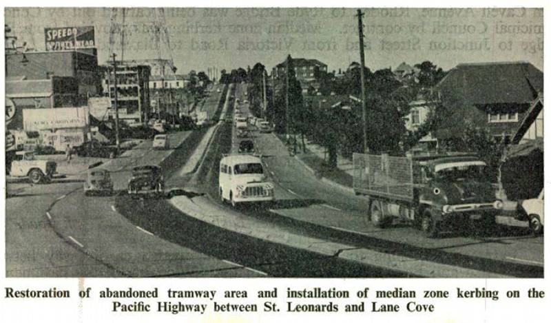
Tramline Conversion:
Restoration of abandoned tramway area and installation of median zone kerbing on the Pacific Hwy between St Leonards and Artarmon, 1960.
Image © Department of Main Roads
|
 |
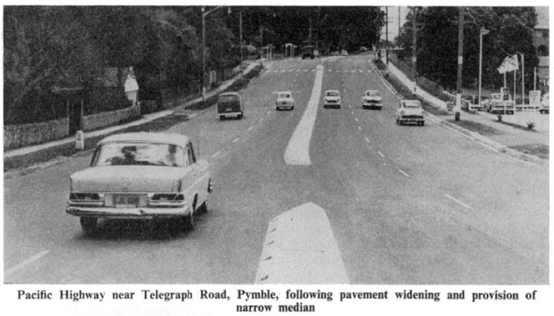
Pymble:
Widened overbridge on the Pacific Hwy at Pymble, 1960.
Image © Department of Main Roads
|
 |
Pymble:
Pacific Hwy near Telegraph Rd, Pymble, following pavement widening and provision of narrow media, 1962.
Image © Department of Main Roads |
 |
Pearce's Corner:
Widened pavement near Pearce's Corner at Wahroonga, 1962.
Image © Department of Main Roads
|
 |
Widened Pavement:
Widened pavement on the Pacific Hwy between Highfield Rd Lindfield and Bushland Rd Gordon, 1963.
Image © Department of Main Roads
|
 |
Hookham's Corner:
Channelised intersection of the Pacific Highway and the Galston-Dural Main Road at Hookham's Corner, Hornsby, 1963.
Image © Department of Main Roads |
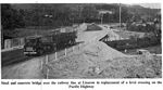 |
Railway Bridge Replacement:
Steel and concrete bridge over the railway line at Lisarow in replacement of a level crossing on Pacific Hwy, 1963.
Image © Department of Main Roads
|
 |
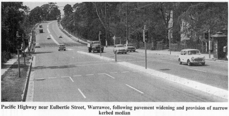
Warrawee:
Pacific Hwy near Eulbertie St at Warrawee, following pavement widening and provision of narrow kerbed median, 1963.
Image © Department of Main Roads
|
 |
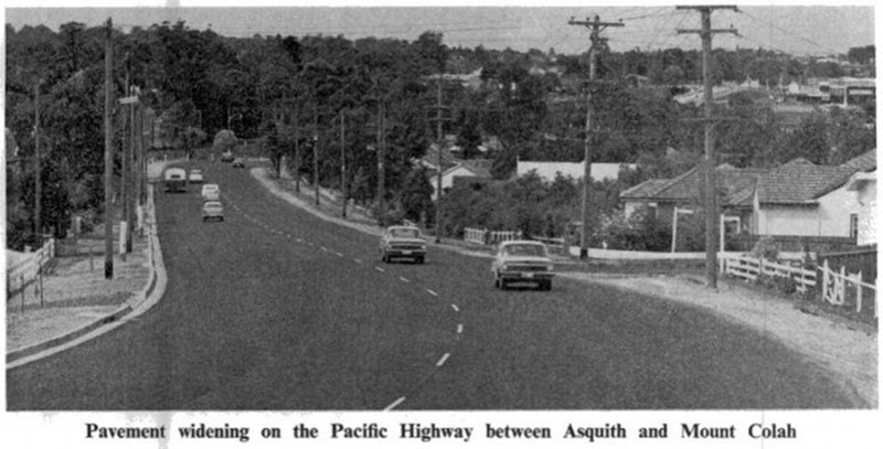
Asquith to Mt Colah:
Pavement widening between Asquith and Mount Colah, 1964.
Image © Department of Main Roads
|
 |
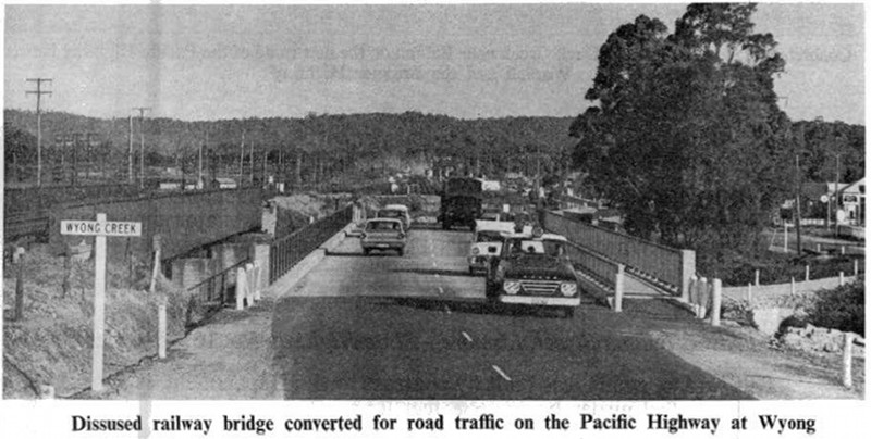
Wyong Creek:
Disused railway bridge converted for road traffic on the Pacific Highway at Wyong, 1964.
Image © Department of Main Roads |
 |
Sign Workshop:
Pacific Hwy & Sydney-Newcastle Tollway signage being manufactured at the DMR shign workshop, Granville, 1965.
Image © Department of Main Roads
|
 |
Gateshead:
Completed dual carriageway upgrade, Gateshead, 1969.
Image © Department of Main Roads
|
 |
Jolls Bridge:
Pacific Hwy at Cheeo Point, with Jolls Bridge carrying Sydney-Newcastle Expressway in the distance, 1972.
Image © Department of Main Roads |
 |
Gateshead:
Completed dual carriageway upgrade, Gateshead, 1977.
Image © Department of Main Roads |
1 Roads and Traffic Authority, Schedule of Classified Roads and State & Regional Roads, 31 January 2011
2 RTA Thematic History, 2nd Edition, 2006
3 Main Roads Board, Annual Report, 1925-26
4 Main Roads Board, Annual Report, 1926-27
5 Main Roads Board, Annual Report, 1927-28
6 Department of Main Roads, Annual Report, 1965-66
7 Main Roads Board, Annual Report, 1930-31
8 Main Roads Board Annual Report, 1932
9 Department of Main Roads, Annual Report, 1932-33
10 Department of Main Roads, Annual Report, 1933-34
11 Department of Main Roads, Annual Report, 1934-35
12 Department of Main Roads, Annual Report, 1937-38
13 Department of Main Roads, Annual Report, 1947-48
14 Department of Main Roads, Annual Report, 1953-54
15 Department of Main Roads, Annual Report, 1954-55
16 Department of Main Roads, Annual Report, 1955-56
17 Department of Main Roads, Annual Report, 1956-57
18 Department of Main Roads, Annual Report, 1957-58
19 Department of Main Roads, Annual Report, 1958-59
20 Department of Main Roads, Annual Report, 1959-60
21 Department of Main Roads, Annual Report, 1960-61
22 Department of Main Roads, Annual Report, 1961-62
23 Department of Main Roads, Annual Report, 1962-63
24 Department of Main Roads, Annual Report, 1963-64
25 Department of Main Roads, Annual Report, 1964-65
26 Department of Main Roads, Annual Report, 1966-67
27 Department of Main Roads, Annual Report, 1967-68
28 Department of Main Roads, Annual Report, 1968-69
29 Department of Main Roads, Annual Report, 1969-70
30 Department of Main Roads, Annual Report, 1970-71
31 Department of Main Roads, Annual Report, 1971-72
32 Department of Main Roads, Annual Report, 1972-73
33 Department of Main Roads, Annual Report, 1973-74
34 Department of Main Roads, Annual Report, 1974-75
35 Department of Main Roads, Annual Report, 1976-77
36 Department of Main Roads, Annual Report, 1977-78
Last updated: 18-Dec-2019 12:04
This site ©
Paul Rands. All rights reserved. Some portions © (copyright) by their respective and credited owners. Permission must be obtained before using any images from this site. For details, please email by clicking here.