|
|
|
|
|

|
Hume Highway (National Highway 31) - Former Alignment: Goulburn To Yass (Decommissioned) |
Statistics:
Route Numbering:

General Information:
The Hume Highway is one of Australia's most vital highway links. Providing access between Sydney and Melbourne, Australia's 2 largest cities. The National Highway section of the Hume Highway consists of almost 100% dual carriageway road, either rural expressway or motorway standard. Works to duplicate small sections of highway that are not dual carriageway are well underway.
In NSW, the highway in one form or another started life as the Great South Road, linking Sydney with the southern highlands and eventually beyond. The highway was named in 1928 after Hamilton Hume (1797-1873), a famous explorer in the early 19th century who, in 1824, in conjunction with William Hovell first found an overland route between Sydney and the infant colonial outpost of Port Phillip, the original name of Melbourne.
NH31 is the main freight and commuter route between Sydney and Melbourne and has gone through a massive amount of transformation over the past 30 or so years, with many towns being bypassed along its route as well and gradual upgrades to motorway standards. Since the 1960s, the road has either been duplicated, where alignments allow for it, and also large deviations have also been part of the upgrade process.
The route around the Mittagong area averages around 16,000 vehicles every day, in other sections the number drops off a little or closer to Sydney increases.1
The route forms the Remembrance Driveway which honours war veterans, click here for the Remembrance Driveway web site.
Here are some interesting statistics on the Hume Highway: 2
History:
This page concentrates on photos of the former alignments between Goulburn and Yass
| Goulburn to Yass | Yass to Goulburn | |||
| Preview: | Description: | Preview: | Description: | |
 |
Main
Southern Railway: Crossing the Main Southern Railway at Yarra, note the old double yellow lines, March 2017. Image © Paul Rands |
 |
Milepost: Concrete milepost on Nelanglo St, Gunning, March 2017. Image © Paul Rands |
|
 |
Black
Intersection Directional Sign: Black ID sign with old NH31 shield facing Bredalbane Rd at Bredalbane, March 2017. Image © Paul Rands |
 |
Main
Southern Railway: Old Hume Hwy (NH31) alignment over the Main South Railway at Gunning, March 2017. Image © Paul Rands |
|
 |
Black
Intersection Directional Sign: Black ID sign at the intersection with Old South Road at Bredalbane, March 2017. Image © Paul Rands |
 |
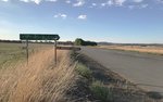
Black
Intersection Directional Sign: Black ID sign at the intersection with Old South Road at Cullerin, March 2017. Image © Paul Rands |
|
 |
Black
Intersection Directional Sign: Black ID sign at the intersection with Old South Road at Cullerin, March 2017. Image © Paul Rands |
 |
Black
Intersection Directional Sign: Black ID sign at the intersection with Old South Road at Bredalbane, March 2017. Image © Paul Rands |
|
 |
Milepost: Concrete milepost on Nelanglo St, Gunning, March 2017. Image © Paul Rands |
|||
1 Roads and
Traffic Authority
2 Department of Infrastructure,
Transport, Regional Development and Local Government
3 Department of Main Roads. The
Roadmakers, A History of Main Roads in New South Wales, ISBN 0 7240 0439 4
Last updated: 05-Jul-2020 19:11
This site © Paul Rands. All rights reserved. Some portions © (copyright) by their respective and credited owners. Permission must be obtained before using any images from this site. For details, please email by clicking here.