
| |
Sydney-Newcastle Freeway (National Highway 1) - Calga to Somersby - Former Alignment: State Highway No. 26 - Dog Trap Road |
Statistics:
Route Numbering:
General Information:
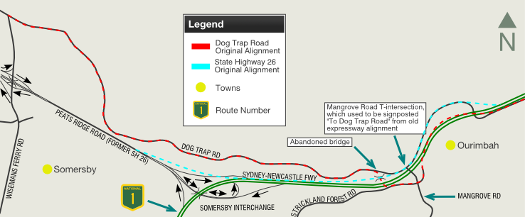
Sections of Dog Trap Road formed part of the Calga-Ourimbah Expressway, a temporary route designed to connect the end of the Sydney-Newcastle Freeway at Calga to the Pacific Highway at Ourimbah.Peats Ridge Road and Dog Trap Road served part of the main route between Sydney and Newcastle from 1964 to 1986, when the Mooney Mooney Creek bridge opened to traffic. Peats Ridge Road and Dog Trap Road both acted as a bypass of the very windy section of the Pacific Highway between Kariong and Calga.
Some of the route is now a local road, but there is an abandoned bridge from the old NH1 aligment, which can be accessed on foot.
How To access The Old Alignment & Abandoned Bridge:
The instructions and map below are based on information supplied by Ben Johnson.
What you can see:
Access to the old alignment:
Travelling from Newcastle:
Travelling from Sydney:
The dual carriageway of the Sydney-Newcastle Fwy ploughed its path through here it literally ate-up parts of the original expressway Peats Ridge Rd and Dog Trap Rd. As a result, the new Dog Trap Rd has been re-routed in and out of old parts of the original expressway. You can tell this from the road width, concrete kerbing, and by the rock cuttings as you drive along here.
Dog Trap Road most likely passed under the Expressway at the abandoned overpass. There were no ramps here. Access to Dog Trap Road was from Mangrove Road, which was a standard T-intersection with the expressway.
History:
The Sydney-Newcastle Freeway (former F3) replaced the old Pacific Highway which was built in the 1920’s along a route that had existed since 1840s, when settler George Peat cut a track to his property on the banks of the Hawkesbury River. 2
Planning began for the freeway in the 1950s, with the aim of providing a high-speed replacement to a section of the Pacific Highway which was built in the 1920s and was struggling to cope with the increased traffic volume. Furthermore it was planned that the freeway would connect to freeway systems being proposed for both Sydney and Newcastle, providing a city-to-city freeway link. However, due to several reasons the goal and route of the freeway changed significantly so that today it serves to bypass Newcastle rather than go into it. 1
Firstly, the route between Mount White and Kariong was originally planned to go further east than the current route with an easier crossing of Mooney Mooney Creek. By the time that construction was to begin on this section resistance from the National Parks and Wildlife Service to the proposed route forced the government to take a route through Calga (Peats Ridge Road), which at the time would have formed part of a route to Singleton. 1
The route through Wyong Shire changed as well; instead of passing along the western edge of the Tuggerah Lakes development in that area resulted in the freeway moving further west with a link road being constructed to meet the Pacific Highway near Doyalson. 1
Perhaps the most significant effect on the freeway's route and its connections was the anti-freeway movement of the 1970s. Strong public resistance to freeways being constructed within cities along with less than favourable results from government inquiries resulted in unconstructed freeway projects being cancelled and those under construction being revised or cut short. For the Sydney-Newcastle Freeway, this meant that the connecting Lane Cove Valley and North-Western Freeways in Sydney would not be built - forcing traffic to travel along the Pacific Highway between Wahroonga and the city. In addition, the freeway would now go to the west of Lake Macquarie rather than the east and bypass Newcastle. Sections of State Route 123, one of the two expressway routes that the freeway would have connected to in Newcastle, have been constructed, while the freeway route between Belmont and Bennetts Green and the connecting expressway route to Merewether are still reserved with the possibility that they could be constructed in the future.
| Somersby to Ourimbah | Ourimbah to Somersby | |||
| Preview: | Description: | Preview: | Description: | |
 |
Abandoned Bridge: As part of the construction of the Somersby Interchange for the Sydney-Newcastle Fwy, a section of State Highway 26 was abandoned nearby. It features a short section of overgrown pavement and a bridge. This is the bridge from Dog Trap Rd, December 2008. Image © Paul Rands |
|
 |
Road Reservation: Wide road reservation at Ourimbah, possibly the remains of an overtaking lane. This is close to where SH26 once joined the current NH1 alignment, December 2008. Image © Paul Rands |
 |
Abandoned Bridge: Old SH26 bridge over what was once Dog Trap Road, Somersby, December 2008. Image © Paul Rands |
|
 |
Cutting & Road Reservation: Looking at the cutting and remains of the SH26 road reservation at Ourimbah, December 2008. Image © Paul Rands |
 |
Abandoned Bridge Deck: Looking across the bridge deck near Dog Trap Rd. The deck is somewhat wider than others along the old SH26 alignment, December 2008. Image © Paul Rands |
|
 |
Cutting & Road Reservation: Looking at the cutting and remains of the SH26 road reservation at Ourimbah, December 2008. Image © Paul Rands |
 |
Old Road reservation: The old expressway reservation from the abandoned bridge, which meets up with the current Dog Trap Road pavement, December 2008. In 2003, some of the old ashphalt was still visible. Image © Paul Rands |
|
 |
Old Armco Barrier: Old Armco barrier, quite some distance from the current pavement, which would indicate the road was once wider, Ourimbah, December 2008. Note the tree growing around the barrier. Image © Paul Rands |
 |
Approaching Mangrove Road: Dog Trap Rd (former SH26 alignment) approaching Mangrove Rd, a section was blasted in the rock to allow a connection to an overpass over the Sydney-Newcastle Fwy when the extension between Calga and Ourimbah was built in the mid 1980s, December 2008. Image © Paul Rands |
|
 |
Old Armco Barrier: Old Armco barrier, quite some distance from the current pavement, which would indicate the road was once wider, Ourimbah, December 2008. Image © Paul Rands |
 |
Rock Cuttings: Typical rock cuttings in the area around the Mangrove Road intersection at Somersby, December 2008. Image © Paul Rands |
|
 |
Rock Cuttings: Typical rock cuttings in the area around the Mangrove Road intersection at Somersby, December 2008. Image © Paul Rands |
 |
Rock Cuttings: Typical rock cuttings in the area around the Mangrove Road intersection at Somersby, December 2008. Image © Paul Rands |
|
 |
Approaching Mangrove Road: Dog Trap Rd (former SH26 alignment) approaching Mangrove Rd, a section was blasted in the rock to allow a connection to an overpass over the Sydney-Newcastle Fwy when the extension between Calga and Ourimbah was built in the mid 1980s, December 2008. Image © Paul Rands |
 |
Disused Rock Cutting: Just after the Mangrove Rd junction is this unusual dual cutting at Ourimbah. The old SH26 was single carriageway but this looks like there were other plans to setup a dual carriageway here or some sort of additional highway facilities, December 2008. Image © Paul Rands |
|
 |
Mangrove Rd Intersection: Junction with Mangrove Rd at Somersby, December 2008. Image © Paul Rands |
 |
Old Road Markings and Pavement: Old roadlines and bitumen creeping out from under newer bitumen at Ourimbah, near unsual dual rock cutting, December 2008. Image © Paul Rands |
|
 |
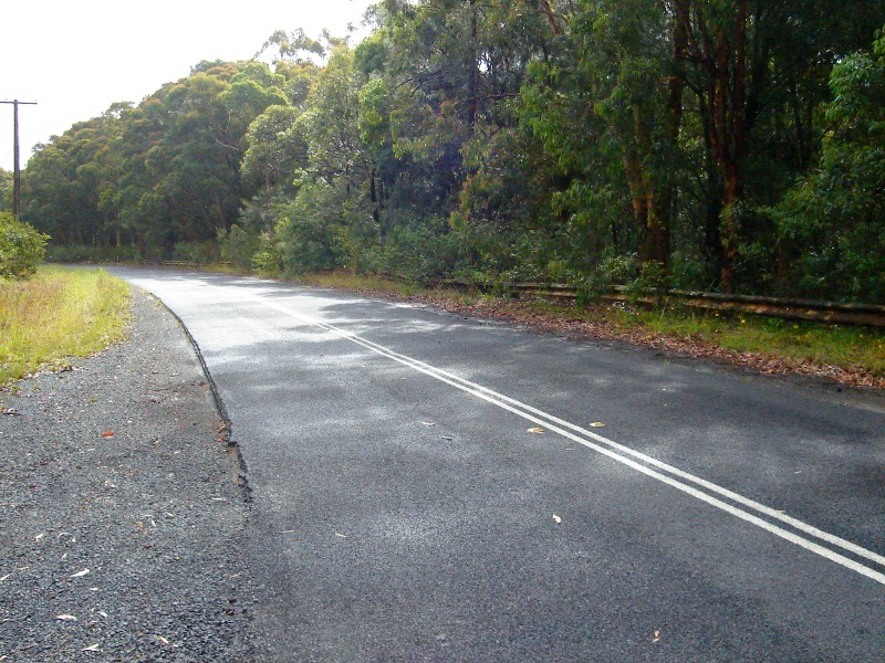
Dog Trap Road near Abandoned Bridge: Dog Trap Road as it bypasses the old bridge at Somersby, December 2008. Image © Paul Rands |
 |
Ourimbah: Photo at Ourimbah on Dog Trap Road, showing the width of the SH26 road reservation and also the kerb and guttering used in the area, which also dates from the construction of SH26, December 2008. Image © Paul Rands |
|
 |
Old Road reservation: The old expressway reservation from the abandoned bridge, which meets up with the current Dog Trap Road pavement, December 2008. In 2003, some of the old ashphalt was still visible. Image © Paul Rands |
 |
Old Road Reservation: The overgrown road reservation where SH26 once joined the current alignment of NH1, Ourimbah, December 2008. Image © Paul Rands |
|
 |
Old Road reservation: The old expressway reservation from the abandoned bridge, which meets up with the current Dog Trap Road pavement, December 2008. In 2003, some of the old ashphalt was still visible. Image © Paul Rands |
| |
 |
Abandoned Bridge Deck: Looking across the bridge deck near Dog Trap Rd. The deck is somewhat wider than others along the old SH26 alignment, December 2008. Image © Paul Rands |
||
| |
 |
Double Yellow Lines: Faint remnants of double yellow lines, which were phased out in NSW during the 1980s. Somersby, December 2008. Image © Paul Rands |
||
| |
 |
Abandoned Bridge: Old SH26 bridge over what was once Dog Trap Road, Somersby, December 2008. Image © Paul Rands |
||
| |
 |
Old Road Reservation: The remains of SH26 west of the abandonded bridge at Somersby, December 2008. Image © Paul Rands |
||
| |
 |
Barrier Post: Old timber post used for Armco barrier near the abandoned bridge at Somersby, December 2008. Image © Paul Rands |
||
1Sam
Laybutt (Ozroads)
2 Roads & Traffic Authority
Thematic History
3 Gosford
City Council
Last updated: 08 Nov 2019 01:09
This site © Paul Rands. All rights reserved. Some portions © (copyright) by their respective and credited owners. Permission must be obtained before using any images from this site. For details, please email by clicking here.