
| B76 | Gwydir Highway & Kamilaroi Highway (B76) - Former Alignment: Moree |
Statistics:
Route Numbering:
General Information:
B76 is a rural highway in northern and western New South Wales, which connects the north coast with outback NSW. For the most part it's undivided, except in a handful of spots.
A section of the route runs parallel with the Gwydir River, and is named after Lord Gwydir by Alan Cunningham who crossed the river at Gravesend in 1827. The section between Walgett and Bourke is named after the Kamilaroi Aboriginal people of north western NSW. 2
During construction of the Moree Bypass, a number of environmental concerns had to be overcome before the section between Alice St (the then Gwydir Hwy) and Amaroo Dr could be completed. The bypass route ran north-south through former fuel storage facilities and the clean up of the location meant that only the northern section of the bypass (Alice St (Gwydir Hwy) to Carnavon Hwy (now Gwydir Hwy)) initially opened to traffic, with the western section of B76 following the existing highway.
Multiplexes along the route include:
History:
This page concentrates on the former alignment in the Moree area
| Grafton To Bourke | Bourke to Grafton | |||
| Preview: | Description: | Preview: | Description: | |
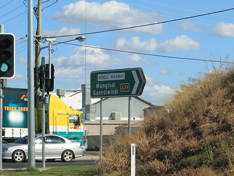 |
Intersection
Directional Sign: ID sign at the corner of Gwydir Hwy (B76) and Newell Hwy (A39) at Moree, May 2011. When this photo was taken, B76 continued straight. Image © Rob Tilley |
 |
Advance
Directional Sign: AD sign on Gwydir Hwy (B76) approaching the roundabout with Newell Hwy (A39) and Alice St in Moree, September 2013. Note the remnant NH39 coverplates. Image © Peter Renshaw |
|
 |
Intersection
Directional Sign: ID sign at the Alice St, Newell Hwy (A39) and Gwydir Hwy (B76) roundabout at Moree. May 2011. Image © Rob Tilley |
 |
Advance
Directional Sign: AD sign approaching Newell Hwy (A39) at Moree. May 2011. The A39 duplex ended at this junction. Image © Rob Tilley |
|
 |
Intersection
Directional Sign: ID sign at the corner of Gwydir Hwy (B76) and Newell Hwy (A39) at Moree, May 2011. When this photo was taken, B76 continued straight. Image © Rob Tilley |
|||
 |
Advance
Directional Sign: AD sign on Newell Hwy (A39) approaching Gwydir Hwy (B76) at Moree. May 2011. Image © Rob Tilley |
|||
 |
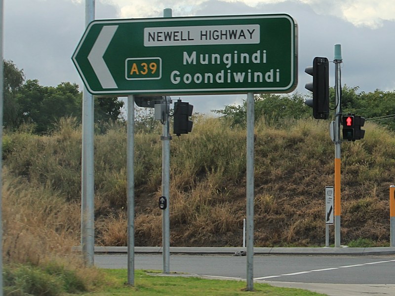
Intersection
Directional Sign: ID sign at the corner of Gwydir Hwy (B76) and Newell Hwy (A39) at Moree, May 2011. Image © Rob Tilley |
|||
1 Roads &
Maritime Services, Schedule of Classified Roads and Unclassified Regional
Roads, August 2013
2 Roads
& Traffic Authority, Heritage and Conservation Register, Brewarrina
Bridge over Barwon River
3 Department of Main Roads, The Roadmakers, A History of Main
Roads in New South Wales, ISBN 0 7240 0439 4
4 Roads & Traffic Authority, Annual
Report 2002
5 National Library of Australia,
Catalogue, Construction
of Jackadgery Bridge, New South Wales, 1959 / Thiess Bros. Pty Ltd.
Last updated: 23-Dec-2019 10:56
This site © Paul Rands. All rights reserved. Some portions © (copyright) by their respective and credited owners. Permission must be obtained before using any images from this site. For details, please email by clicking here.