Road Photos & Information: Victoria
Statistics:
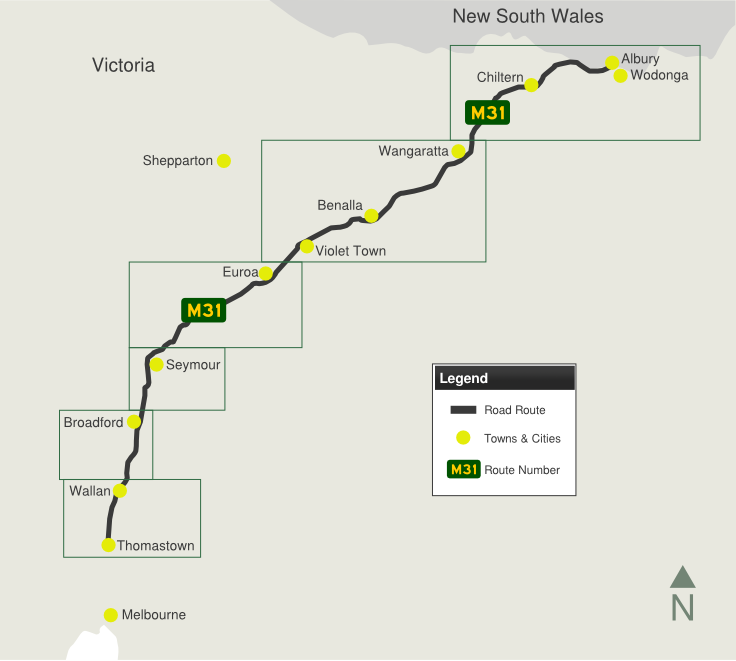
- Length: 303 km
- Northern Terminus:
NSW-Vic Border at Wodonga
- Southern Terminus:
Interchange with Metropolitan Ring Road at Thomastown
- Miscellaneous:
Continues as Hume Highway (M31) in NSW
- Suburbs, Towns &
Localities along route: Wodonga, West Wodonga, Barnawartha,
Chiltern, Springhurst, Boralma, Bowser, East Wangaratta, Wangaratta
South, Laceby, Glenrowan, Glenrowan West, Winton, Benalla, Baddaginnie,
Violet Town, Balmattum, Euroa, Longwood East, Avenel, Seymour,
Northwood, Tallarook, Broadford, Waterford Park, Wandong, Wallan, Wallan
East, Beveridge, Kalkallo, Craigieburn, Epping and Thomastown.
Route Numbering:
- Multiplexes: B400
- Road Authority Internal Number:
1550
General Information:
The Hume Freeway is one of Australia's most vital
highway links. Providing access between Sydney and Melbourne, Australia's
2 largest cities. Formerly known as the Hume Highway, the route is 100%
dual carriageway road, either rural expressway or motorway standard.
The route started life as Sydney Road, cutting through
Melbourne's northern suburbs. The highway was named in 1928 after Hamilton
Hume (1797-1873), a famous explorer in the early 19th century who, in
1824, in conjunction with William Hovell first found an overland route
between Sydney and the infant colonial outpost of Port Phillip, the
original name of Melbourne.
M31 is the main freight and commuter route between
Sydney and Melbourne and has gone through a massive amount of
transformation over the past 30 or so years, with many towns being
bypassed along its route as well and gradual upgrades to motorway
standards. Since the 1960s, the road has either been duplicated, where
alignments allow for it, and also large deviations have also been part of
the upgrade process. Around 66,000 vehicles use the Hume Freeway north of
Melbourne every day. 1
The Hume Freeway's highest elevation along its length is
368m and the lowest point is at 90.8m
History:
- 1914: Sydney Road declared a main road. 3
- 1928: Sydney Road renamed the Hume Highway - still a
narrow two lane road. 3
- 1954: Hume Highway given Australia's first National
Route number, NR31, as a trial of numbering systems.
- 1960's: Fawkner to Somerton duplication 4
- 1961: The first 4 lane modern freeway standard
section was completed in Victoria at Craigieburn.
- 1969: Hume Freeway bypass from Wallan to Broadford
started. 3
- 1974: Hume Highway route number changed to National
Highway 31, indicating it's importance and also funding by the Federal
Government.
- 1976: Hume Freeway - a modern 4 lane highway opened
by the Premier of Victoria Rupert J Hamer. 3
- 1980: Violet Town bypassed 4
- 1982: Seymour bypassed 4
- 1984: Longwood duplication & bypass construction
4
- 1985: Wodonga bypassed 4
- 1987: Benalla bypassed 4
- 1988: Glenrowan and Chiltern bypassed 4
- 1992: Euroa bypassed 4
- 1994: Springhurst bypassed 4
- 1997: NH31 number replaced with NH-M31 as part of the
rollout of alphanumeric numbering. NH31 remained in the metropolitan
area until the opening of Craigieburn Bypass. 4
- December 2004: The first section of the Craigieburn
Bypass was opened to traffic between the Metropolitan Ring Road and
Cooper Street. 1
- 20 December 2005: The remaining section of the 17km
Craigieburn Bypass, linking the Hume Freeway near Mt. Ridley Road at
Craigieburn, to the Metropolitan Ring Road at Thomastown, opened to
traffic. 2
- 2006: Old NH31 designation in suburban Melbourne
replaced with MR55.
- 6 March 2007: 17.4km upgrade of the Hume Freeway
through Albury-Wodonga opened to traffic. 2
1 Department of Infrastructure, Transport, Regional Development and Local Government
2 Vicroads
3 Wandong-Heathcote Junction Community Group
4 Viseth Uch
Last updated: 14-Feb-2019 21:32
This site © Paul Rands. All rights reserved. Some portions © (copyright) by their respective and credited owners. Permission must be obtained before using any images from this site. For details, please email by clicking here.


