|
|
|
|
|
| A3 | Cross Road (A3) |
Statistics:
Route Numbering:
General Information:
Cross Road is a major east-west route that passes through Adelaide's inner southern suburbs. It's a multi-laned arterial standard route, connecting Adelaide's east suburbs and hills to Adelaide's western suburbs. A3 forms part of Adelaide's Outer City Ring Route. 2
More than 50,000 vehicles pass through the Cross Road and Marion Road intersection each day. 3
History:

| Preview: | Description: |
 |
Advance Directional Sign: AD sign approaching Goodwood Rd in Clarence Park, October 2009. Image © Paul Rands |
 |
Approaching Victoria Avenue: Cross Road, eastbound, approaching Victoria Avenue in Unley Park, October 2009. Image © Paul Rands |
 |
Advance Directional Sign: AD sign approaching the intersection with View Street, Unley Road, and Belair Road (TD57) at Unley Park, October 2009. Image © Paul Rands |
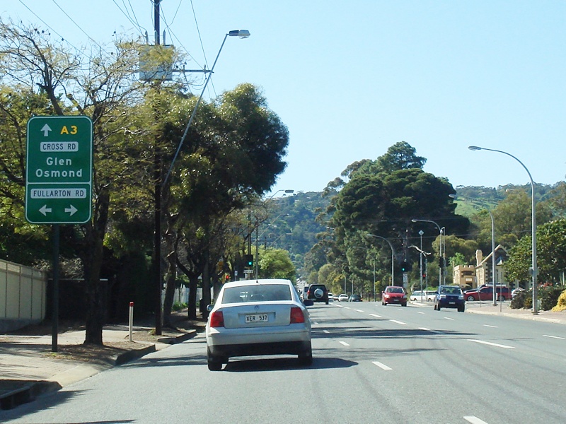 |
Advance Directional Sign: AD sign approaching Fullarton Road, Highgate, October 2009. Image © Paul Rands |
 |
Advance Directional Sign: AD sign near Glenfora Av in Myrtle Bank for the junction with Waite Rd, October 2009. Image © Paul Rands |
 |
Advance Directional Sign: AD sign approaching Glen Osmond Rd (A1), Princes Hwy (Adelaide-Crafers Hwy) and Portrush Rd (NH-A17) at Myrtle Bank, October 2009. Image © Paul Rands |
 |
Glen Osmond Road, Princes Highway and Portrush Road Intersection: Intersection directional sign at the junction with Glen Osmond Rd (A1), Princes Hwy (Adelaide-Crafers Hwy) and Portrush Rd (NH-A17) at Myrtle Bank, October 2009. Image © Paul Rands |
1 Transport SA, State Route Numbers map, Metropolitan Region, May 2003
2 Transport SA, Robe Terrace Upgrade, Submission to the Parliamentary Public Works Committee, April 2000
3 Transport SA, News & Media Releases, Cross Road and Marion Road intersection improvements, 25 November 2005
4 Australian Railway Historical Society, Bulletin 336, October 1965
5 Michael Greenslade
6 Transport SA, News & Media Releases, Safety Improvements to Cross Road Level Crossing, Unley Park, 27 January 2004
7 Transport SA, News & Media Releases, Traffic Light Upgrade - Cross Road and Duthy Street, Highgate, 22 April 2005.
8 Transport SA, News & Media Releases, Traffic Diversions at Cross Road Level Crossing, 16 June 2005
Last updated: 08-Feb-2019 19:35
This site © Paul Rands. All rights reserved. Some portions © (copyright) by their respective and credited owners. Permission must be obtained before using any images from this site. For details, please email by clicking here.