|
|
|
|
|
 |
Peats Ridge Road, George Downes Drive, Great North Road, Wollombi Road, Allandale Road & Wine Country Drive (Tourist Drive 33) |
Statistics:
Route Numbering:


General Information:
Tourist Drive 33 runs through the heart of rural and wine country, and takes in some of what were once some of New South Wales most important roads.
From the Sydney-Newcastle Fwy at Calga, the route follows Peats Ridge Road (formerly Peats Ridge Expressway). This was the main north-south route between what used to be the end of the Sydney-Newcastle Tollway, joining up with an alignment of the Pacific Hwy at Ourimbah. That said, TD33 only covers the Calga to Peats Ridge section of that route.
The other once important link in the NSW road system is the Great North Road. It was built by convict labour, often working in irons, between 1826 and 1836 to connect Sydney with Newcastle and the Upper Hunter Valley. 2 For full information and history of the Great North Road, click here.
TD33 is duplexed with SR82 between Cessnock and Branxton (Allandale Rd & Wine Country Dr).
History:
The Pacific Highway for a time travelled along Peat's Ridge Road (then Expressway) from the 60s to the 80s as a Super 2 continuation of the Sydney-Newcastle Tollway. The route was National Highway 1 from 1974 to 1986, and carried most of the traffic between Calga and Ourimbah. From 1962 to 1974 it was National Route 1. 1
Peats Ridge Road, on the NSW Central Coast, itself was constructed purposely by the DMR to take the National Highway 1 shield (then National Route 1) as the main route between Sydney & Newcastle. However, it was not given the NH1 shield until the arrival of federal funding via the National Highway system in 1974. Prior to this, the route was signposted as either 'Newcastle via Peats Ridge' or 'Sydney via Peats Ridge' at the end of the F3 Freeway. 2
Peats Ridge Rd carried expressway traffic for 22 years (12 years as NH1) until the 7km shorter expressway route between Calga and Somersby opened to traffic. Some of the original route was retained, the 7km between Somersby and Ourimbah was duplicated and incorporated into the Sydney-Newcastle Freeway. National Highway 1 was removed from Peats Ridge Rd in December 1986, however signage remained along the expressway section well into 2004.1 1

| Calga to Branxton | Branxton to Calga | |||
| Preview: | Description: | Preview: | Description: | |
 |
Advance Directional Sign: Travelling northbound on the Sydney-Newcastle Fwy at Calga as you approach the interchange with Peats Ridge Rd. March 2007. Image © Paul Rands |
 |
Distance Sign: Start of SR82 and TD33, Clift Street (Wine Country Drive) in Branxton, September 2005. Note the missing TD33 shield on this sign. Image © Paul Rands |
|
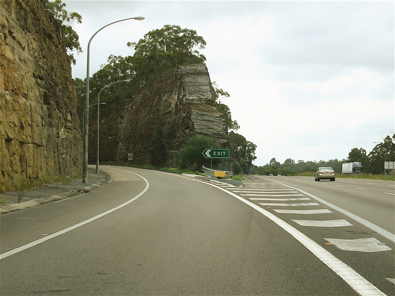 |
Peats Ridge Road Interchange: Northbound on the onramp to Peats Ridge Road from Sydney-Newcastle Freeway at Calga. March 2007. Note the steep cuttings into the sandstone. Image © Paul Rands |
 |
Intersection Directional Sign: ID sign facing southbound traffic approaching Drinan Street in Branxton. September 2005. Image © Paul Rands |
|
 |
Peats Ridge Road Interchange: Northbound on the onramp to Peats Ridge Road from Sydney-Newcastle Freeway at Calga. March 2007. Image © Paul Rands |
 |
Intersection Directional Sign: ID sign on Drinan Street in Branxton. September 2005. Image © Paul Rands |
|
 |
Advance Directional Sign: AD sign on the ramp to Peats Ridge Road at Calga, March 2007. This was once the main connection from the Sydney-Newcastle Freeway to the Pacific Highway to Gosford. Image © Paul Rands |
 |
Tourist Drive Distance Sign: Sign indicating distances to tourist orientated destinations along the route. September 2005 at North Rothbury. Image © Paul Rands |
|
 |
Peats Ridge Road / Pacific Highway Access Road Split: Advance directional sign for Peats Ridge Road, and the southbound carriageway of Peats Ridge Road which connects with the Pacific Highway. Calga, March 2007. Image © Paul Rands |
 |
Distance Sign: Painted, non reflective distance sign as you leave North Rothbury. September 2005. Image © Paul Rands |
|
 |
Sydney-Newcastle Freeway: The leg of Peats Ridge Road, east of the Sydney-Newcastle Fwy as it passes under the freeway. This once the main access to Peats Ridge Road from the Pacific Highway. Calga, March 2007. Image © Paul Rands |
 |
Entering Cessnock: Entering Cessnock from Wine Country Drive, September 2005. Image © Paul Rands |
|
 |
Peats Ridge Road Overpass: Travelling under Peats Ridge Road overpass at Calga. These 2 bridges once carried north and southbound traffic for NH1. Calga, March 2007. Image © Paul Rands |
 |
Advance Directional Sign: AD sign at Central Mangrove approaching Wisemans Ferry Rd, December 2008. Image © Paul Rands |
|
 |
Peats Ridge Road Interchange: Looking southbound as the Peats Ridge Road ramp loops onto the bridges in the previous shot. March 2007 at Calga. Image © Paul Rands |
 |
Wisemans Ferry Road: Corner of George Downes Dr (TD33) at the junction with Wisemans Ferry Rd (former SR36) at Central Mangrove, December 2008. Image © Paul Rands |
|
 |
Distance Sign: The first northbound RD sign on TD33. Located on Peats Ridge Road at Calga. February 2005. Image © Paul Rands |
 |
Distance Sign: RD sign at Central Mangrove, December 2008. Image © Paul Rands |
|
 |
Northbound Carriageway: Northbound carriageway of Peats Ridge Road at Calga. This was once connected directly to the northbound carriageway of the Sydney-Newcastle Freeway. February 2005. Image © Paul Rands |
 |
Advance Directional Sign: AD sign approaching Peats Ridge Rd (former NH1) at Peats Ridge, December 2008. TD33 turns right at this junction. Image © Paul Rands |
|
 |
Peats Ridge: TD33 as it passes through the town centre of Peats Ridge. February 2005. This was once the main stop for people making the trip from Sydney to Newcastle. Oak Dairy had a massive food outlet here on the right of shot. Image © Paul Rands |
 |
Peats Ridge Road: Intersection directional signage facing George Downs Dr (TD33) at Peats Ridge, December 2008. TD33 turns right at this junction Image © Paul Rands |
|
 |
Advance Directional Sign: AD sign approaching George Downes Drive at Peats Ridge, TD33 veers off at the upcoming intersection to follow George Downes Drive. February 2005. Image © Paul Rands |
 |
Peats Ridge: Peats Ridge Rd (TD33) as it passes through the Peats Ridge town centre, December 2008. Image © Paul Rands |
|
 |
George Downes Dr Intersection: Channelised junction with George Downes Drive. TD33 veers left here. The old NH1 alignment veers right. Peats Ridge, February 2005. Image © Paul Rands |
 |
Advance Directional Sign: AD sign at Calga approaching Cooks Rd, December 2008. Image © Paul Rands |
|
 |
Wisemans Ferry Road: Corner of George Downes Dr (TD33) at the junction with Wisemans Ferry Rd (former SR36) at Central Mangrove, December 2008. Image © Paul Rands |
 |
Cooks Road: Corner of Peats Ridge Rd (TD33) and Cooks Rd in Calga, December 2008. Image © Paul Rands |
|
 |
Distance Sign: RD sign at Central Mangrove, December 2008. Image © Paul Rands |
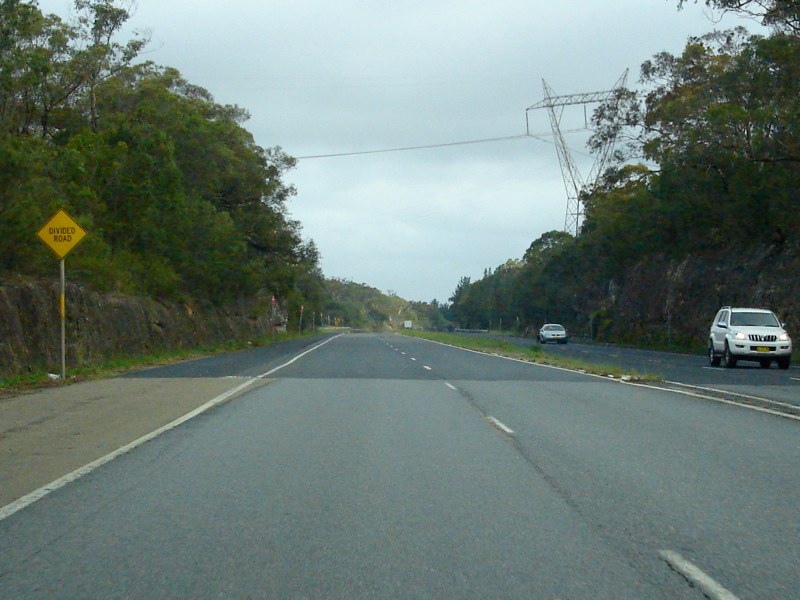 |
Approaching Divided Road: Divided section of Peats Ridge Rd (TD33) at Calga, December 2008. This section joined Peats Ridge Rd with the Sydney-Newcastle Fwy (NH1). Click here for a photo by Paul Rands of an old Peats Ridge Rd alignment alongside the current one in this area from December 2008. Image © Paul Rands |
|
 |
Black Intersection Directional Sign: Black ID sign facing Maitland Road (SR132) traffic in Cessnock. September 2005. Image © Paul Rands |
 |
Freeway Green Advance Directional Sign: Freeway green AD sign approaching the interchange Sydney-Newcastle Fwy (NH1) at Calga, December 2008. Image © Paul Rands |
|
 |
Intersection Directional Sign: ID sign on the corner of Broke Road and Wine Country Drive at Lovedale, September 2005. Image © Paul Rands |
 |
Sydney-Newcastle Freeway Interchange: Southern terminus of TD33: the interchange with Sydney-Newcastle Fwy (NH1) at Calga, December 2008. Image © Paul Rands |
|
 |
Intersection Directional Signs: ID signs on the Drinan Street intersection at Branxton, September 2005. Image © Paul Rands |
|||
 |
End TD33 / SR82: The northern terminus of both TD33 and SR82 at the New England Hwy at Branxton, September 2005. Image © Paul Rands |
|||
1 Cessnock City Council
2 Sam Laybutt
3 Convict Trail Project
Last updated: 17-Dec-2019 0:55
This site © Paul Rands. All rights reserved. Some portions © (copyright) by their respective and credited owners. Permission must be obtained before using any images from this site. For details, please email by clicking here.