Road Photos & Information: New South Wales

|
|
Appin Road, Narellan Road, Bridge Street, Putty Road, Thomas Street, Ryan Avenue, John Street, Queen Street, Campbell Street (State Route 69) (Decommissioned) - Historic Photos |
Statistics:
- Length: 208 km (Windsor to Singleton: 174 km) (Campbelltown to Maddens Plains (Bulli Tops): 34 km)
- Northern
Terminus:
- Northern section: New England Highway (NH15) and Campbell Street at Singleton
- Southern section: Hume Highway (NH31 and Metroad 5) and Narellan Road (Metroad 9) at Campbelltown
- Southern
Terminus:
- Northern section: Windsor Road (Metroad 2) and Macquarie Street (Metroad 9) at Windsor.
- Southern section: Southern Freeway (NR1) and Princes Highway (SR60) at Maddens Plains (Bulli Tops)
- Miscellaneous: State Route 69 is in 2 sections after Metroad 9 replaced it between Windsor and Campbelltown
- Suburbs, Towns
& Localities Along The Route:
- Northern section: Windsor, Wilberforce, East Kurrajong, Colo, Colo Heights, Putty, Milbrodale, Bulga, Mt Thorley and Singleton
- Southern section: Maddens Plains (Bulli Tops), Appin, Rosemeadow, Ambarvale and Campbelltown
Route Numbering:
- Former:
- Multiplexes:


- Road Authority
Internal Classification:
- Northern section: MR128 (Mt Thorley to Singleton), MR182 (Windsor to Wilberforce), MR503 (Wilberforce to Mt Thorley).
- Southern section: MR177 (Maddens Plains (Bulli Tops) to Narellan Road at Campbelltown) and MR178 (Appin Road to Hume Highway interchange at Campbelltown) 1
- Decommissioned: 2013 (Windsor to Singleton did not be receive a alphanumeric route number) 2
General Information:
State Route 69 is one of the more unusual routes in the NSW state route system. It's split into 2 sections. The northern section consists mainly of undivided single carriageway road. The southern section is mostly the same except around the Campbelltown area where it's generally 4-lane and 6-lane divided arterial road.
Both sections service residential, commercial and agricultural areas, but also pass through national park and state forests.
The northern section is quite windy in parts and is an alternate route from Sydney to the Hunter Valley but generally sees a lower volume of traffic than the southern section which connects the southwestern outskirts of Sydney with the city of Wollongong.
Multiplexes along the route include:
- State Route 56, at Campbelltown for 900 m
- State Route 84, Golden Highway, at Mt Thorley for 2 km
- Tourist Drive 27, between Mt Thorley and Singleton for 12 km
History:
- 1820: Howes Line (now Putty Road) was built, with a river crossing at Bulga. 3
- 1942: As part of defence works in NSW, a road from Windsor via Wilberforce, Putty and Howes Valley to Singleton was constructed. It substanitally followed the first overland route between Sydney and the Hunter Valley. 4
- 1980s: Alignment improvements between Bulli Tops (Maddens Plains) and Appin.
- 1990s: State Route 69 replaced by Metroad 9 between Campbelltown and Windsor.
- 2000: Replacement of timber culverts along Putty Road. 5
- 6 April 2011: Safety upgrade work commences on Putty Road between Milbrodale and Putty. The project involved rock and tree removal, rock bolting, and installing wire mesh to stabilise the slope. 6
This page concentrates on historic photos of State Route 69
 |
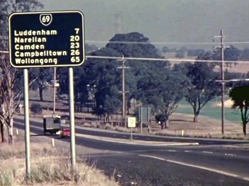
Black Reassurance Directional Sign:
Black distance sign after the Western Fwy (F4) interchange on The Northern Rd (SR69) at Orchard Hills, 1971.
Image © Department of Main Roads |
1 Roads & Traffic Authority, Schedule of Classified Roads and State & Regional Roads, 31 January 2011
2 Roads & Traffic Authority, Signposting Guidelines
3 Roads & Traffic Authority, Self Guided Tours, Historic Bridges of the Hunter
4 Department of Main Roads, The Roadmakers, A History of Main Roads in New South Wales, ISBN 0 7240 0439 4
5 Roads and Traffic Authority, Annual Report 2000
6 Roads & Traffic Authority, News & Events, Media Release, Work Starts on Putty Road, 6 April 2011
Last updated: 20-Dec-2019 13:49
This site © Paul Rands. All rights reserved. Some portions © (copyright) by their respective and credited owners. Permission must be obtained before using any images from this site. For details, please email by clicking here.