|
|
|
|
|
 |
Appin Road, Narellan Road, Bridge Street, Putty Road, Thomas Street, Ryan Avenue, John Street, Queen Street, Campbell Street (State Route 69) - Singleton to Windsor (Decommissioned) |
Statistics:
Route Numbering:


General Information:
State Route 69 is one of the more unusual routes in the NSW state route system. It's split into 2 sections. The northern section consists mainly of undivided single carriageway road. The southern section is mostly the same except around the Campbelltown area where it's generally 4-lane and 6-lane divided arterial road.
Both sections service residential, commercial and agricultural areas, but also pass through national park and state forests.
The northern section is quite windy in parts and is an alternate route from Sydney to the Hunter Valley but generally sees a lower volume of traffic than the southern section which connects the southwestern outskirts of Sydney with the city of Wollongong.
Multiplexes along the route include:
History:
| Windsor to Singleton | Singleton to Windsor | |||
| Preview: | Description: | Preview: | Description: | |
 |
Windsor Road & Macquarie Street: The southern terminus of the northern segment of SR69, the junction with Windsor Rd (Metroad 2) and Macquarie St (Metroad 9) in Windsor, December 2004. These signs have all since been replaced. Image © Paul Rands |
 |
Black Advance Directional Sign: Black AD sign on the off ramp from New England Hwy (NH15) approaching Queen St (SR69) in Singleton, December 2008. Image © Paul Rands |
|
 |
Narrow Bridge: Narrow bridge sign approaching Hawkesbury River at Windsor, June 2011. Image © Paul Rands |
 |
Queen Street: Ramp from New England Hwy (NH15) at the junction with Queen St in Singleton, December 2008. SR69 turns left at this junction. Image © Paul Rands |
|
 |
Hawkesbury River: Bridge St Windsor as it crosses Hawkesbury River, June 2011. Image © Paul Rands |
 |
Campbell Street: Intersection directional sign at the junction with Queen St (SR69), John St (SR69) and Campbell St (SR69) in Singleton, December 2008. Image © Paul Rands |
|
 |
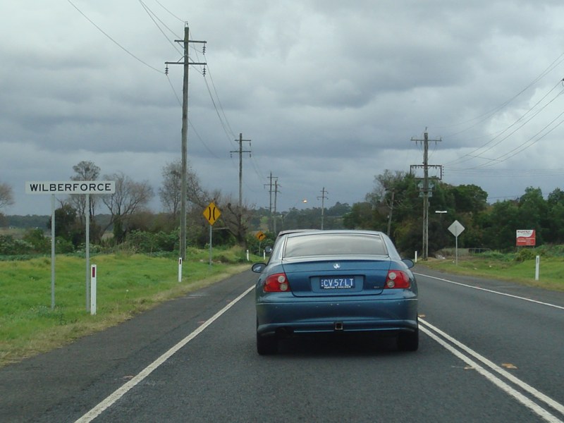
Advance Directional Sign: AD sign at Wilberforce outside Macquarie Park approaching Freemans Reach Rd, June 2011. Image © Paul Rands |
 |
Advance Directional Sign: AD sign approaching John St, Hunter St and Ryan Av (SR69) in Singleton, December 2008. Note the incorrect shield shape and colours. SR69 used to be routed through the CBD along John St. Image © Paul Rands |
|
 |
Distance Sign: RD sign at Wilberforce, June 2011. Image © Paul Rands |
 |
Ryan Avenue: ID sign at the corner of Hunter St, John St and Ryan Av in Singleton, December 2008. Note the incorrect shield shape and colours. SR69 turns right at this junction. Image © Paul Rands |
|
 |
Entering Wilberforce: Putty Rd as it enters the Wilberforce town centre, June 2011. Image © Paul Rands |
 |
Black Council Directional Sign: Black AD style sign designed by council on Ryan Av in Singleton near the John St junction, July 2005. Image © Paul Rands |
|
 |
Advance Directional Sign: AD sign approaching King Rd at Wilberforce, December 2004. Image © Paul Rands |
 |
Black Intersection Directional Sign: Black ID sign on the corner of Ryan Av and John St in Singleton, July 2005. Image © Paul Rands |
|
 |
King Road: Corner of Putty Rd (William St) and King Rd at Wilberforce. SR69 swings left at this junction, June 2011. Image © Paul Rands |
 |
Black Intersection Directional Sign: Black ID sign on the corner of Ryan Av and John St in Singleton, July 2005. Note the incorrect shield shape. Image © Paul Rands |
|
 |
Intersection Directional Sign: ID sign facing East Kurrajong Rd at East Kurrajong, December 2004. Image © Paul Rands |
 |
Intersection Directional Sign: ID sign on the corner of Ryan Av and John St in Singleton, July 2005. Note the incorrect shield shape and colours. Image © Paul Rands |
|
 |
Advance Directional Sign: AD sign at Blaxlands Ridge approaching Blaxlands Ridge Rd, December 2004. Image © Paul Rands |
 |
Intersection Directional Sign: ID sign facing Milbrodale Rd at Milbrodale, February 2005. Note the incorrect shield shape and colours. Image © Paul Rands |
|
 |
Colo: Putty Rd as it passes through the Colo area, December 2004. Image © Paul Rands |
 |
Intersection Directional Sign: ID sign at the junction with Creek Ridge Rd and Stannix Park Rd in Wilberforce, December 2004. Image © Paul Rands |
|
 |
Fruit Quarantine Sign: Sign prohibiting grapes being brought into the Hunter region, Howes Valley, December 2004. Image © Paul Rands |
 |
Advance Directional Sign: AD sign approaching King Rd at Wilberforce, June 2011. Image © Paul Rands |
|
 |
Public Phone Sign: Due to the isolation along Putty Rd, public phones have been placed in a few areas, and signs were erected showing distance to the next one, Milbrodale, December 2004. Image © Paul Rands |
 |
King Road: Corner of Putty Rd (William St) and King Rd at Wilberforce. SR69 swings right at this junction, June 2011. Image © Paul Rands |
|
 |
Advance Directional Sign: AD sign at Milbrodale approaching Milbrodale Rd, December 2004. Image © Paul Rands |
 |
Distance Sign: RD sign at Wilberforce, June 2011. Image © Paul Rands |
|
 |
Entering Bulga: Putty Rd as it enters the town of Bulga, December 2004. Image © Paul Rands |
 |
Truck Load Checking Area: Putty Rd at the truck load checking area at Wilberforce, June 2011. Image © Paul Rands |
|
 |
Advance Directional Sign: AD sign approaching Wambo Rd in Bulga's town centre, December 2004. Image © Paul Rands |
 |
Narrow Bridge: Narrow bridge sign approaching Hawkesbury River at Wilberforce, June 2011. Image © Paul Rands |
|
 |
Bulga Bridge: Timber truss bridge over Wollombi Brook at Bulga, December 2004. Image © Paul Rands |
 |
Freemans Reach Road: Corner of Putty Rd and Freemans Reach Rd at Wilberforce, June 2011. Image © Paul Rands |
|
 |
Advance Directional Sign: AD sign at Bulga approaching Wallaby Scrub Rd and Charlton Rd, December 2004. Image © Paul Rands |
 |
Hawkesbury River: Bridge St Windsor as it crosses Hawkesbury River, June 2011. Image © Paul Rands |
|
 |
Charlton Road: Putty Rd (SR69) at the junction with Charlton Rd in Bulga, June 2006. Image © Paul Rands |
 |
Entering Windsor Town Centre: Bridge St (SR69) as it enters the Windsor town centre, June 2011. Image © Paul Rands |
|
 |
Wallaby Scrub Road: Putty Rd (SR69) at the junction with Wallaby Scrub Rd in Bulga, June 2006. Image © Paul Rands |
 |
Advance Directional Sign: AD sign on Bridge St (SR69) approaching the roundabout with George St in Windsor, June 2011. Click here for a photo from January 2005 of the original sign installation. Image © Paul Rands |
|
 |
Intersection Directional Sign: ID sign at Bulga facing Wallaby Scrub Rd, December 2004. Note the modification to the road name by a local. Image © Paul Rands |
 |
Advance Directional Sign: AD sign on Bridge St (SR69) approaching the junction with Windsor Rd (Metroad 2) and Macquarie St (Metroad 9) in Windsor, June 2011. Click here for a photo from May 2004 of the previous sign. Image © Paul Rands |
|
 |
Mt Thorley: Putty Rd (SR69) as it passes under a mine access road in Mt Thorley, June 2006. Image © Paul Rands |
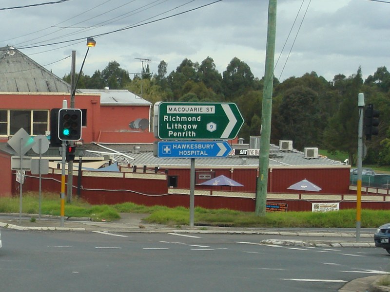 |
Windsor Road & Macquarie Street: The southern terminus of the northern segment of SR69, the junction with Windsor Rd (Metroad 2) and Macquarie St (Metroad 9) in Windsor, June 2011. Click here for a photo from October 2005 of the previous sign. Image © Paul Rands |
|
 |
Mt Thorley: Putty Rd (SR69) as it passes under a mine access road in Mt Thorley, June 2006. Image © Paul Rands |
|||
 |
Advance Directional Sign: AD sign on Putty Rd (SR69) approaching the Mt Thorley Rd and Golden Hwy (SR84 / TD27) interchange at Mt Thorley, June 2006. Image © Paul Rands |
|||
 |
Mt Thorley Road & Golden Highway: Putty Rd (SR69) at the interchange with Mt Thorley Rd and Golden Hwy (SR84 / TD27) at Mt Thorley, June 2006. Image © Paul Rands |
|||
 |
Distance Sign: Reassurance directional sign at Mt Thorley, June 2006. Image © Paul Rands |
|||
 |
Distance Sign: Tourism based RD sign at Mt Thorley, June 2006. Image © Paul Rands |
|||
 |
Advance Directional Sign: AD sign approaching Broke Rd at Mt Thorley, June 2006. Image © Paul Rands |
|||
 |
Advance Directional Sign: AD sign approaching Golden Hwy (SR84) at Mt Thorley, June 2006. Image © Paul Rands |
|||
 |
Golden Highway: Corner of Putty Rd (SR69) and Golden Hwy (SR84) at Mt Thorley, June 2006. Image © Paul Rands |
|||
 |
Hunter Tourist Circuit Sign: Old map sign of the now defunct Hunter Tourist Circuit, Singleton, June 2006. Image © Paul Rands |
|||
 |
Black Intersection Directional Sign: Black ID sign with incorrect shaped route shield facing Carrington St in Singleton, June 2006. Image © Paul Rands |
|||
 |
Advance Directional Sign: AD sign with erroneous NR69 shield approaching John St and Ryan Av (SR69) at Singleton, June 2006. Image © Paul Rands |
|||
 |
Ryan Avenue: ID sign at the junction of Ryan Av and John St in Singleton, July 2005. SR69 turns left at this junction. Note the incorrect shield shape and colours. Image © Paul Rands |
|||
 |
Advance Directional Sign: AD sign on Ryan Av approaching John St and Hunter St in Singleton, June 2006. Note the incorrect shield shape and colours. Image © Paul Rands |
|||
 |
Hunter & John Streets: Ryan Av at the junction with John St and Hunter St in Singleton, July 2005. SR69 turns left at this junction. Note the incorrect shield shape and colours. Image © Paul Rands |
|||
 |
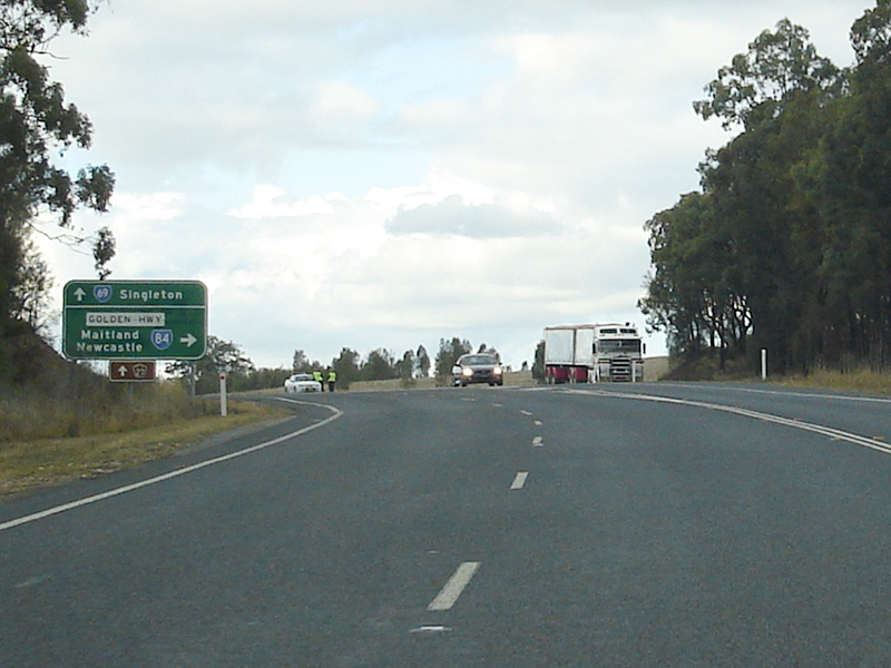
Intersection Directional Sign: ID sign assembly at the corner of John St, Dunolly Rd and Campbell St (SR69) in Singleton, June 2006. Image © Paul Rands |
|||
 |
Advance Directional Sign: AD sign on Campbell St (SR69) approaching New England Hwy (NH15) at Singleton, June 2006. Image © Paul Rands |
|||
 |
New England Highway: The northern terminus of the northern segment of State Route 69, the junction with New England Hwy (NH15) and Campbell St in Singleton, December 2008. Image © Paul Rands |
|||
| Click here for State Route 69 between Campbelltown and Maddens Plains (Bulli Tops) (Decommissioned) | ||||
1 Roads & Traffic Authority, Schedule of Classified Roads and State & Regional Roads, 31 January 2011
2 Roads & Traffic Authority, Signposting Guidelines
3 Roads & Traffic Authority, Self Guided Tours, Historic Bridges of the Hunter
4 Department of Main Roads, The Roadmakers, A History of Main Roads in New South Wales, ISBN 0 7240 0439 4
5 Roads and Traffic Authority, Annual Report 2000
6 Roads & Traffic Authority, News & Events, Media Release, Work Starts on Putty Road, 6 April 2011
Last updated: 08 Nov 2019 01:09
This site © Paul Rands. All rights reserved. Some portions © (copyright) by their respective and credited owners. Permission must be obtained before using any images from this site. For details, please email by clicking here.