|
|
|
|
|
| John Renshaw Drive, Mulbring Street, Tarro Street, Victoria Street, Mitchell Avenue, Northcote Street, First Street, Station Street, Cessnock Road & Maitland Road (State Route 132) (Decommissioned) |
Statistics:
Route Numbering:
General Information:
State Route 132 is a major Hunter region east-west route, joining the Pacific and New England Highways with the coal mining and tourist areas of Kurri Kurri and Cessnock.
History:

| Cessnock to Beresfield | Beresfield to Cessnock | |||
| Preview: | Description: | Preview: | Description: | |
 |
AD Sign: Advance directional sign as you travel southwest on Lang Street (SR135) at Kurri Kurri, approaching the intersection of Mitchell Av and Victoria St. September 2007. SR132 duplexes with SR135 from this intersection through to Railway St. Image © Paul Rands |
 |
John Renshaw Drive: Eastern tip of SR132 as it joins the Sydney-Newcastle Freeway (NH1), Weakleys Drive and the Pacific Highway (NR1) at Beresfield. October 2005. Image © Paul Rands |
|
 |
Advance Directional Sign: Southbound AD sign on Victoria Street in Kurri Kurri as you approach the roundabout with Railway Street (SR135). September 2007. The SR135 duplex ends at the Railway Street roundabout. Image © Paul Rands |
|||
 |
Intersection Directional Sign: ID sign facing Railway Street traffic on the roundabout with Tarro & Victoria Streets in Stanford Methyr. September 2007. Image © Paul Rands |
|||
 |
Black Distance Sign: Black RD located on Tarro Street as you look southwest at Stanford Methyr. September 2007. Image © Paul Rands |
|||
 |
Advance Directional Sign: AD sign as you approach George Booth Dr (SR128) at Buchanan, September 2007. Image © Paul Rands |
|||
 |
Surveyors Creek & George Booth Drive Intersection: Eastbound at Buchanan as you cross Surveyors Creek and approach the roundabout with George Booth Drive (S128), September 2007. Image © Paul Rands |
|||
 |
Buttai: Typical eastbound conditions in the Buttai area. September 2007. Image © Paul Rands |
|||
 |
Black Hill Road Intersection: Eastbound through the Black Hill Road intersection at Black Hill, September 2007. Image © Paul Rands |
|||
 |
Entering Beresfield: Sign indicating the town of Beresfield, September 2007. Image © Paul Rands |
|||
 |
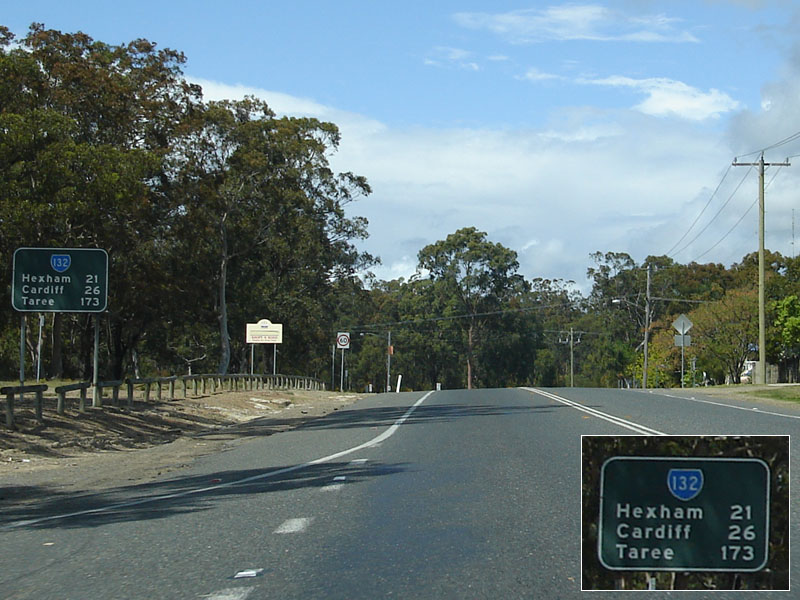
Advance Directional Sign: AD sign for the Weakleys Drive / Sydney-Newcastle Freeway / Pacific Highway roundabout at Beresfield, September 2007. Image © Paul Rands |
|||
 |
Weakleys Drive / Sydney-Newcastle Freeway / Pacific Highway roundabout: Eastbound approaching the Weakleys Drive / Sydney-Newcastle Freeway / Pacific Highway roundabout at Beresfield, September 2007. Image © Paul Rands |
|||
 |
End SR132: Fuzzy photo of the End State Route 132 sign on the eastern side of the Weakleys Drive / Sydney-Newcastle Freeway / Pacific Highway roundabout at Beresfield, September 2007. Image © Paul Rands |
|||
 |
Approaching Weakleys Drive / Sydney-Newcastle Freeway / Pacific Highway roundabout: Southbound advance directional sign on Weakleys Drive at Beresfield, March 2007. Image © Paul Rands |
|||
1 Roads & Traffic Authority
2 Cessnock City Council
Last updated: 17-Dec-2019 0:55
This site © Paul Rands. All rights reserved. Some portions © (copyright) by their respective and credited owners. Permission must be obtained before using any images from this site. For details, please email by clicking here.