|
|
|
|
|
 |
Kamilaroi Highway (National Route 37) - Narrabri to Gunnedah (Decommissioned) |
Statistics:
Route Numbering:


General Information:
The highway is named after the Kamilaroi Aboriginal people of north western NSW. 2 The route connects the Hunter Valley with the far northwest outback of New South Wales.
The route consists of mostly single carriageway undivided roadway, passing through nature reserves, farmland, commercial and residential areas.
Multiplexes along the route include:
History:
| Gunnedah to Narrabri | Narrabri to Gunnedah | |||
| Preview: | Description: | Preview: | Description: | |
 |
Advance Directional Sign: AD sign on Oxley Hwy (NR34) approaching the roundabout with Kamilaroi Hwy (NR37) at Gunnedah, April 2005. The NR37 duplex begins here. Note the missing NR37 shield on the Gunnedah side of the sign. Image © Paul Rands |
 |
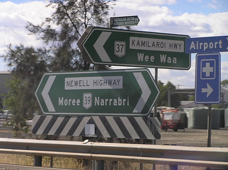
Advance Directional Sign: AD sign on Newell Hwy (NH39) approaching Kamilaroi Hwy (NR37) in Narrabri, May 2011. Click here for a photo of the previous sign from July 2005. Image © Rob Tilley |
|
 |
Kamilaroi Highway: Corner of Oxley Hwy (NR34) and Kamilaroi Hwy (NR37) at Gunnedah, October 2006. The NR34 duplex begins here as well. Image © Paul Rands |
 |
Kamilaroi Highway: Newell Hwy (NH39) at the junction with Kamilaroi Hwy (NR37) in Narrabri, May 2011. The NH39 duplex starts at this junction. Image © Rob Tilley |
|
 |
Distance Sign: Reassurance directional sign on the outskirts of Gunnedah, after the Oxley Hwy (NR34) roundabout, April 2005. Image © Paul Rands |
 |
Advance Directional Sign: AD sign in Narrabri approaching Barwan St & Killarney St, May 2011. NR37 and NH39 turn right at this junction. Click here for a photo of the previous sign from July 2005. Image © Rob Tilley |
|
 |
Entering Gunnedah Town Centre: Welcome sign as the highway enters the town of Gunnedah, August 2005. Image © Paul Rands |
 |
Barwan Street & Killarney Street: ID sign on the roundabout with Barwan St & Killarney St in Narrabri, July 2005. Click here for a photo of the previous sign from July 2005. Image © Paul Rands |
|
 |
Advance Directional Sign: AD sign approaching Abbott St and Oxley Hwy (NR34), April 2005. Image © Paul Rands |
 |
Intersection Directional Sign: ID sign at the roundabout with Killarney St and Barwan St in Narrabri, May 2011. Image © Rob Tilley |
|
 |
Kamilaroi Highway & Abbott Street: Intersection directional sign assembly outside the Courthouse Hotel in Gunnedah at the junction with Oxley Hwy (NR34) and Abbott St, April 2005. The NR34 duplex ends at this juncton. Image © Paul Rands |
 |
Intersection Directional Sign: ID sign at the roundabout with Killarney St and Barwan St in Narrabri, May 2011. Image © Rob Tilley |
|
 |
Conadilly
Street Gunnedah: Northbound through the CBD. August 2005. Image © Paul Rands |
 |
Intersection Directional Sign: ID signs as the highway negotiates way around the Narrabri CBD, May 2011. This is where Killarney St changes to Tibbereena St. Image © Rob Tilley |
|
 |
Black Distance Sign: Black RD sign as Kamilaroi Hwy (NR37) leaves Gunnedah, December 2002. Image © Michael Greenslade |
 |
Advance Directional Sign: AD sign in Narrabri approaching the Kamilaroi Hwy (NR37) / Newell Hwy (NH39) and Tibbereena St roundabout, May 2011. Image © Rob Tilley |
|
 |
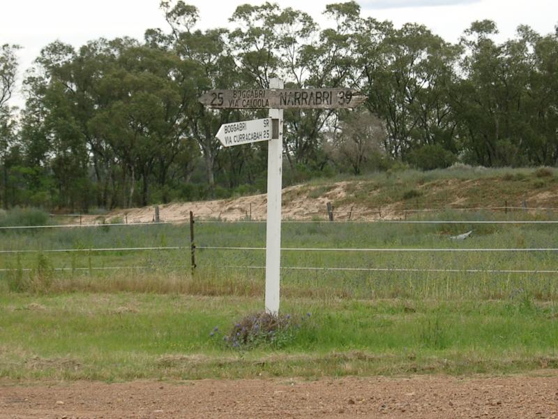
Wooden
Directional Fingerboard: On the corner of Wee Waa and Boston Streets, Boggabri. October 2005. This sign has since been removed and replaced with metal fingerboards. Image © Paul Rands |
 |
Tibbereena Street: ID sign in Narrabri at the Tibbereena St roundabout, May 2011. Image © Rob Tilley |
|
 |
Wooden
Directional Fingerboard: Old timber sign on Baranbah St in Boggabri, just off the Kamilaroi Hwy (NR37). October 2005. Image © Paul Rands |
 |
Black Intersection Directional Sign: Black ID sign in Narrabri at the Tibbereena St roundabout, July 2005. Image © Paul Rands |
|
 |
Advance Directional Sign: AD sign on the Newell Hwy (NH39) at Narrabri approaching the Kamilaroi Hwy (NR37) roundabout, November 2010. Click here for a photo by Rob Tilley from April 2005 of the previous sign. The NH39 duplex begins at this junction. Note the missing NR37 shield. Image © Rob Tilley |
 |
Advance DIrectional Sign: AD sign at Narrabri approaching Mooloobar St, July 2005. Image © Paul Rands |
|
 |
Intersection Directional Sign: ID sign at Narrabri at the Newell Hwy (NH39) roundabout, November 2010. Note the missing NR37 shield. Click here for a photo by Rob Tilley from April 2005 of the previous sign. Image © Rob Tilley |
 |
Intersection Directional Sign: ID sign at the Mooloobar St roundabout in Narrabri, May 2011. Click here for a photo of the previous sign from July 2005. Image © Rob Tilley |
|
 |
Entering Narrabri: Welcome sign as the highway enters the Narrabri town centre, November 2010. Image © Rob Tilley |
 |
Advance Directional Sign: AD sign in Narrabri approaching Kamilaroi Hwy (NR37) / Newell Hwy (NH39) roundabout, May 2011. Click here for a photo of this location by Michael Greenslade from January 2003. Image © Rob Tilley |
|
 |
Advance Directional SIgn: AD sign at Narrabri approaching Mooloobar St, April 2005. Note the missing NR37 shield. Image © Rob Tilley |
 |
Intersection Directional Sign: ID sign in Narrabri at the Newell Hwy (NH39) roundabout, May 2011. Click here for a photo of the previous sign from July 2005. The NH39 duplex ends at this junction. Image © Rob Tilley |
|
 |
Intersection Directional SIgn: ID sign at Narrabri at the roundabout with Mooloobar St, November 2010. Note the missing NR37 shield. Image © Rob Tilley |
 |
Distance Sign: RD sign as the Kamilaroi Hwy (NR37) leaves Narrabri, July 2005. Image © Paul Rands |
|
 |
Ugoa Street: Kamilaroi Hwy (NR37) at the junction with Ugoa St in Narrabri, November 2010. Image © Rob Tilley |
 |
Distance Sign: RD sign as the Kamilaroi Hwy (NR37) leaves Narrabri, July 2005. Image © Paul Rands |
|
 |
Advance Directional Sign: AD sign approaching Tibbereena St and Narrabri Ck in Narrabri, November 2010. Note the missing NR37 shield. Image © Rob Tilley |
 |
Entering Baan Baa: Kamilaroi Hwy (NR37) as it enters the town of Baan Baa, July 2005. Image © Paul Rands |
|
 |
Tibbereena Street: Intersection directional sign at the junction with Tibbereena St in Narrabri, November 2010. Click here for a photo by Rob Tilley from April 2005 of the previous sign. NR37 and NH39 turn left at this junction. Note the missing NR37 shield. Image © Rob Tilley |
 |
Advance Directional Sign: AD sign at Boggabri approaching Rangari Rd, July 2005. Image © Paul Rands |
|
 |
Distance Sign: RD sign in the Narrabri CBD, October 2005. Note the missing NR37 shield. Image © Paul Rands |
 |
Distance
Sign: Distance signage outside Boggabri with incorrect route shield. July 2005. Image © Paul Rands |
|
 |
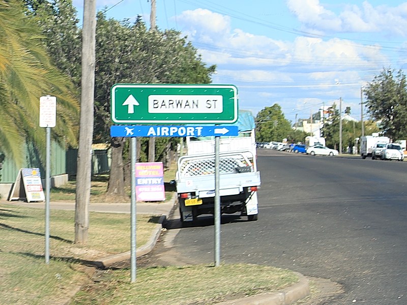
Advance Directional Sign: AD sign approaching Barwan St and Killarney St in Narrabri, November 2010. NR37 and NH39 turns left at this intersection. Note the missing NR37 shield. Image © Rob Tilley |
 |
50km/h zone sign: Sign announcing that Boggabri's streets are all 50 km/h zones. July 2005. Image © Paul Rands |
|
 |
Intersection Directional Sign: ID sign at the roundabout with Barwan St and Killarney St in Narrabri, April 2005. Note the missing NR37 shield. Image © Rob Tilley |
 |
Entering Boggabri: Kamilaroi Hwy (NR37) as it enters the town of Boggabri. July 2005. Image © Paul Rands |
|
 |
Intersection Directional Sign: ID sign at the roundabout with Barwan St and Killarney St in Narrabri, November 2010. Note the missing NR37 shield. Image © Rob Tilley |
 |
Intersection Directional Sign: ID sign at the corner of Kamilaroi Hwy (NR37), Grantham St and Wee Waa St at Boggabri. NR37 turns left at this junction. July 2005. Image © Paul Rands |
|
 |
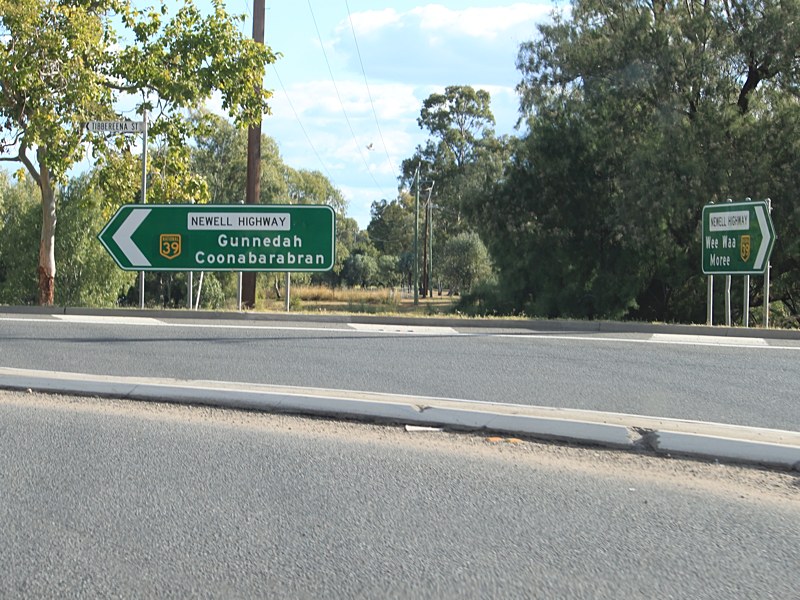
Advance Directional Sign: AD sign at Narrabri approaching the Kamilaroi Hwy (NR37) / Newell Hwy (NH39) split, November 2010. Click here for a photo by Rob Tilley from April 2005 of the previous sign. Click here for a photo from October 2005, that was also located nearby but since been removed. Image © Rob Tilley |
 |
Intersection Directional Sign: ID sign at the corner of Kamilaroi Hwy (NR37), Grantham St and Wee Waa St at Boggabri. NR37 turns left at this junction. July 2005. Note the incorrect font on the sign. Image © Paul Rands |
|
 |
Intersection Directional Sign: ID sign at Narrabri at the Kamilaroi Hwy (NR37) & Newell Hwy (NH39) junction, November 2010. Click here for a photo by Rob Tilley from April 2005 of the previous sign. The NH39 duplex ends at this junction. Image © Rob Tilley |
 |
Namoi River: Kamilaroi Hwy (NR37) as it crosses Namoi River at Boggabri. July 2005. Image © Paul Rands |
|
 |
Distance
Sign: RD sign as Kamilaroi Hwy (NR37) leaves Narrabri. January 2003. Image © Michael Greenslade |
 |
Distance Sign: Reassurance directional sign as Kamilaroi Hwy (NR37) leaves Boggabri. July 2005. Image © Paul Rands |
|
 |
Bald Hill Road: Corner of Kamilaroi Hwy (NR37) and Bald Hill Rd near Narrabri, October 2005. Image © Paul Rands |
 |
Heavy
Vehicle Station near Gunnedah: Sign for the heavy vehichle inspection station at Gunnedah. July 2005. Image © Paul Rands |
|
 |
Spring Plain Road: Corner of Kamilaroi Hwy (NR37) and Spring Plain Rd near Narrabri, October 2005. Image © Paul Rands |
 |
Distance Sign: Combined services and distance sign approaching Gunnedah. July 2005. Image © Paul Rands |
|
 |
Conadilly
Street Gunnedah: Southbound through the CBD. August 2005. Image © Paul Rands |
|||
 |
Advance Directional Sign: AD sign on Kamilaroi Hwy (NR37) approaching Abbott St and Oxley Hwy (NR34), April 2005. Image © Paul Rands |
|||
 |
Kamilaroi Highway & Abbott Street: Intersection directional sign assembly in Gunnedah at the junction with Oxley Hwy (NR34) and Abbott St, April 2005. The NR34 duplex begins at this juncton. Image © Paul Rands |
|||
 |
Kamilaroi Highway & Abbott Street: Intersection directional sign assembly in Gunnedah at the junction with Oxley Hwy (NR34) and Abbott St, April 2005. The NR34 duplex begins at this juncton. Image © Paul Rands |
|||
 |
Advance Directional Sign: AD sign approaching the roundabout with Oxley Hwy (NR34) at Gunnedah, April 2005. The NR34 duplex ends at this intersection. Image © Paul Rands |
|||
 |
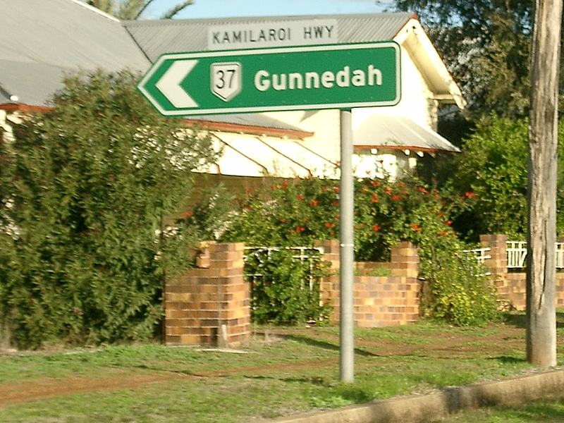
Reassurance Directional Sign: Distance sign at Gunnedah, December 2002. Image © Michael Greenslade |
|||
| Click here for the continuation of NR37 between Gunnedah and Willow Tree Click here for the continuation of NR47 between Walgett and Narrabri |
||||
1 Roads & Traffic Authority, Schedule of Classified Roads and State & Regional Roads, January 2011
2 Roads & Traffic Authority, Annual Report 2000, November 2000, ISSN 1037-3276
3 Roads & Traffic Authority, Annual Report 2002
Last updated: 19-Oct-2021 0:47
This site © Paul Rands. All rights reserved. Some portions © (copyright) by their respective and credited owners. Permission must be obtained before using any images from this site. For details, please email by clicking here.