|
|
|
|
|
 |
Great Western Highway, Mitchell Highway & Barrier Highway (National Route 32) - Nyngan to Dubbo (Decommissioned) |
Statistics:
Route Numbering:
General Information:
National Route 32 is the main route linking the New South Wales state capital, Sydney, with the west of the state. The road varies from arterial road conditions, rural expressway and rural highway.
The Mitchell Highway links north-western NSW with Dubbo, Bathurst and eventually Sydney.
The highway starts at Bathurst as National Route 32 and heads west through the Great Dividing Range to Orange then continues north through Molong, Wellington and Dubbo. From Dubbo, the highway follows the Bourke railway line in a north-westerly direction to Nyngan. The highway's route number changes to NR71 (after the Barrier Highway junction at Nyngan), and then it continues north-west to Bourke and terminates at the QLD border, just north of Barringun.
The Mitchell Highway is named after Major Thomas Mitchell, who was Surveyor-General of New South Wales in the 1820s and explored much of inland New South Wales and Victoria.
History:
| Nyngan to Dubbo | Dubbo to Nyngan | |||
| Preview: | Description: | Preview: | Description: | |
 |
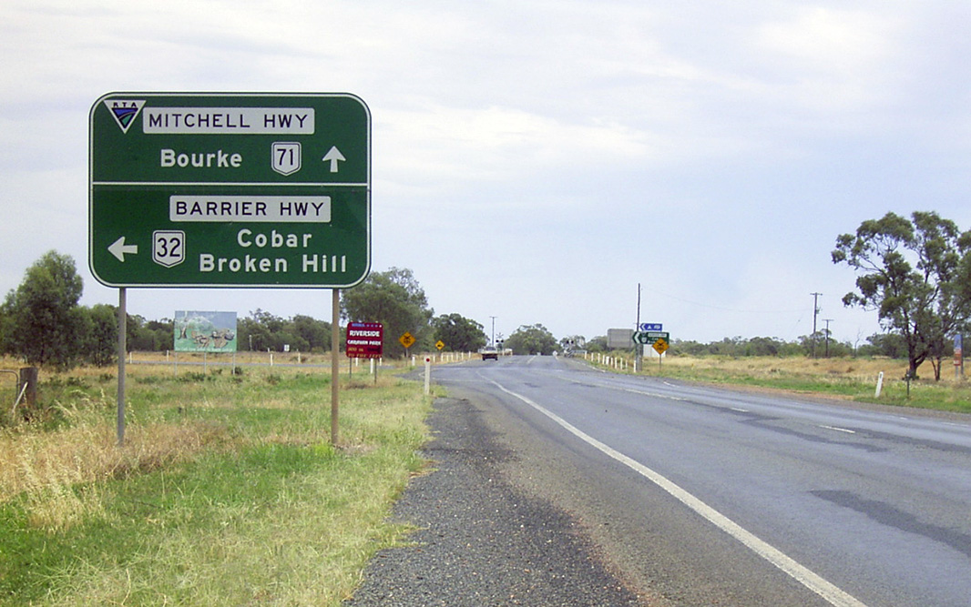
Advance Directional Sign: AD sign on Barrier Hwy (NR32) at Nyngan approaching Mitchell Hwy (NR71 & NR32), August 2011. Click here for a photo of this location by Richard Wardle from March 2006. Image © Paul Rands |
 |
Entering Narromine: Image © Paul Rands |
|
 |
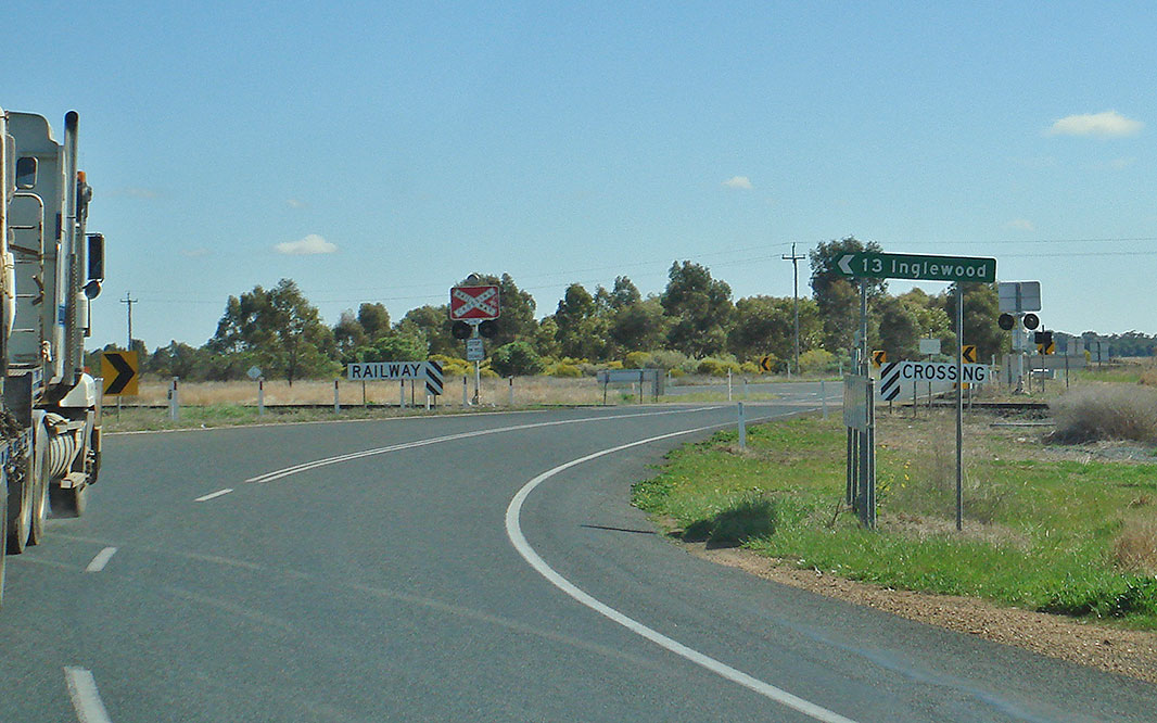
Intersection Directional Sign: ID sign at the corner of Barrier Hwy (NR32) and Mitchell Hwy (NR32 and NR71) at Nyngan, August 2011. NR32 turns right at this junction and becomes Mitchell Hwy. Image © Paul Rands |
 |
Advance Directional Sign: Heavy vehicle detour AD sign approaching Manildra St, Narromine, August 2011. Image © Paul Rands |
|
 |
Bogan River: Mitchell Hwy (NR32) crossing Bogan River via Peter Sinclair Bridge at Nyngan, August 2011. Image © Paul Rands |
 |
Manildra Street: Corner of Mitchell Hwy (NR32) and Manildra St at Narromine, August 2011. Image © Paul Rands |
|
 |
Advance Directional Sign: AD sign at Nyngan approaching Noomagee St and Pangee St, August 2011. Image © Paul Rands |
 |
Advance Directional Sign: AD sign at Narromine approaching Dandaloo St, August 2011. Image © Paul Rands |
|
 |
Intersection Directional Sign: ID sign at the junction with Noomagee St and Pangee St, Nyngan, August 2011. Image © Paul Rands |
 |
Dandaloo Street: Corner of Mitchell Hwy (NR32) and Dandaloo St at Narromine, August 2011. Image © Paul Rands |
|
 |
Intersection Directional Sign: ID sign at the junction with Noomagee St and Pangee St, Nyngan, August 2011. Image © Paul Rands |
 |
Narromine: Mitchell Hwy (NR32) (Dandaloo St) as it passes through the town of Narromine, August 2011. Image © Paul Rands |
|
 |
Intersection Directional Sign: ID sign at the junction with Hospital Rd, Nyngan, August 2011. Image © Paul Rands |
 |
Advance Directional Sign: AD sign at Narromine approaching Warren Rd, August 2011. Image © Paul Rands |
|
 |
Intersection Directional Sign: ID sign at the junction with Mulla Rd, Nyngan, August 2011. Image © Paul Rands |
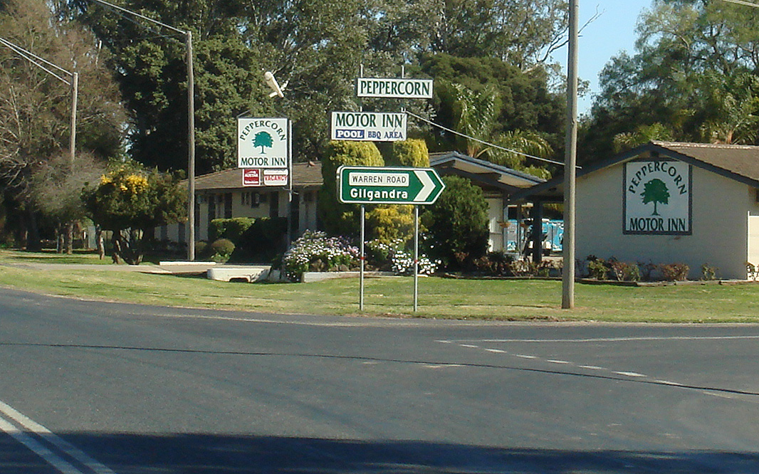 |
Warren Road: Corner of Mitchell Hwy (NR32) and Warren Rd at Narromine, August 2011. Image © Paul Rands |
|
 |
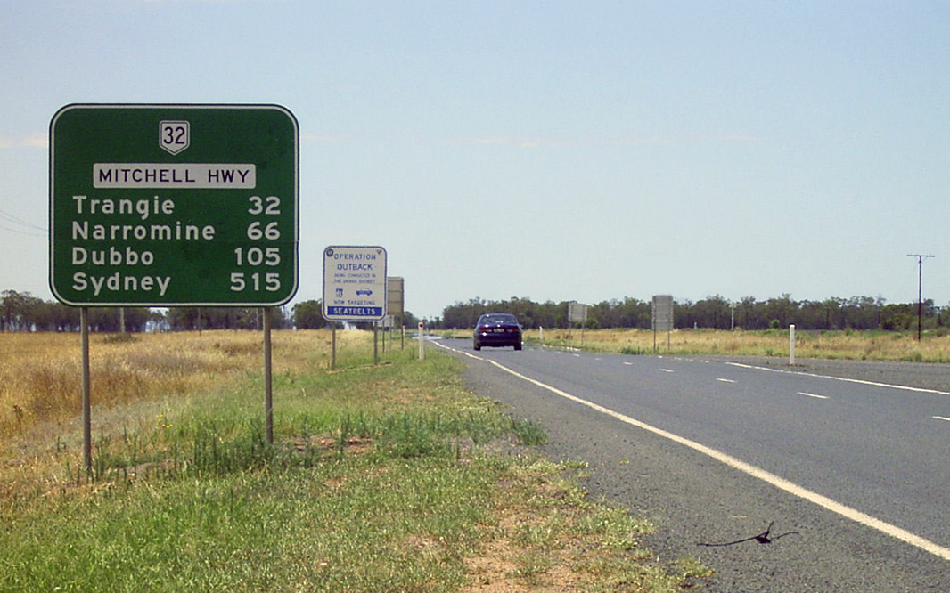
Reassurance Directional Sign: Distance sign at Nyngan, December 2003. Image © Michael Greenslade |
 |
Tom Perry Drive: Corner of Mitchell Hwy (NR32) and Tom Perry Dr at Narromine, August 2011. Image © Paul Rands |
|
 |
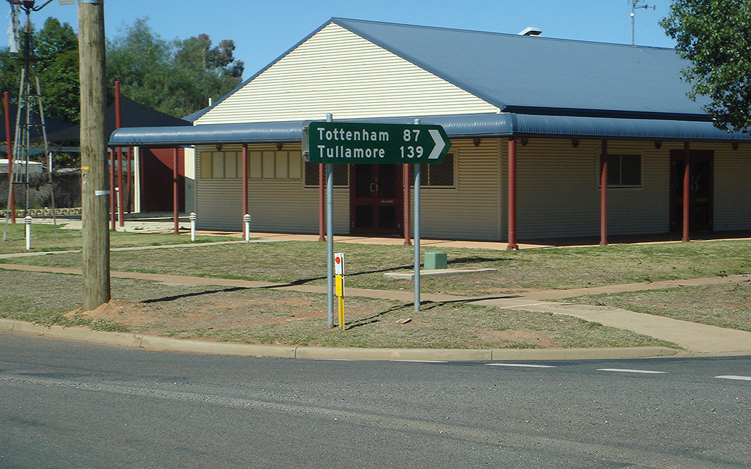
Reassurance Directional Sign: Tourism-based distance sign at Mullengudgery, August 2011. Image © Paul Rands |
 |
Weemabah Road: Corner of Mitchell Hwy (NR32) and Weemabah Rd at Trangie, August 2011. Image © Paul Rands |
|
 |
Nevertire: Mitchell Hwy (NR32) as it passes through the town of Nevertire, August 2011. Image © Paul Rands |
 |
Entering Trangie: Image © Paul Rands
|
|
 |
Advance Directional Sign: AD sign approaching Oxley Hwy (NR34) and Nevertire-Bogan Rd at Nevertire, August 2011. Image © Paul Rands |
 |
Advance Directional Sign: AD sign at Trangie approaching Trangie-Collie Rd, August 2011. Image © Paul Rands |
|
 |
Intersection Directional Sign: ID sign at the junction with Oxley Hwy (NR34) and Nevertire-Bogan Rd at Nevertire, August 2011. Image © Paul Rands |
 |
Goan Waterhole: Mitchell Hwy (NR32) crossing Goan Waterhole at Trangie, August 2011. Image © Paul Rands |
|
 |
Reassurance Directional Sign: Distance sign at Nevertire, August 2011. Click here for a photo of this location by Michael Greenslade from December 2003. Image © Paul Rands |
 |
Advance Directional Sign: AD sign approaching Narromine St, Trangie, August 2011. Image © Paul Rands |
|
 |
Advance Directional Sign: AD sign approaching Narromine St, Trangie, August 2011. Image © Paul Rands |
 |
Advance Directional Sign: AD sign approaching Dandaloo St, Trangie, August 2011. Image © Paul Rands |
|
 |
Dandaloo Street: Corner of Mitchell Hwy (NR32) and Dandaloo St at Trangie, August 2011. Image © Paul Rands |
|||
 |
Enmore Road: Corner of Mitchell Hwy (NR32) and Enmore Rd at Trangie, August 2011. Image © Paul Rands |
|||
 |
Entering Nevertire: Mitchell Hwy (NR32) as it enters the town of Nevertire, August 2011. Image © Paul Rands |
|||
 |
Advance Directional Sign: AD sign approaching Oxley Hwy (NR34) and Nevertire-Bogan Rd at Nevertire, August 2011. Image © Paul Rands |
|||
 |
Nevertire: Mitchell Hwy (NR32) as it passes through the town of Nevertire, August 2011. Image © Paul Rands |
|||
 |
Reassurance Directional Sign: Tourism-based distance sign at Mullengudgery, August 2011. Image © Paul Rands |
|||
 |
Entering Nyngan: Image © Michael Greenslade |
|||
 |
Intersection Directional Sign: ID sign at the junction with Hospital Rd, Nyngan, August 2011. Image © Paul Rands |
|||
 |
Advance Directional Sign: Image © Michael Greenslade |
|||
 |
Mitchell Street: Corner of Mitchell Hwy (NR32) and Mitchell St at Nyngan, August 2011. Image © Paul Rands |
|||
 |
Advance Directional Sign: AD sign approaching Moonagee St in Nyngan, August 2011. Image © Paul Rands |
|||
 |
Moonagee Street: Corner of Mitchell Hwy (NR32) and Moonagee St at Nyngan, August 2011. Image © Paul Rands |
|||
 |
Intersection Directional Sign: ID sign at the junction with Noomagee St and Pangee St, Nyngan, August 2011. Image © Paul Rands |
|||
 |
Bogan River: Mitchell Hwy (NR32) crossing Bogan River via Peter Sinclair Bridge at Nyngan, August 2011. Image © Paul Rands |
|||
 |
Supplemental Advance Directional Sign: Supplemental AD sign at Nyngan approaching Mitchell Hwy (NR71) and Barrier Hwy (NR32), August 2011. Image © Paul Rands |
|||
 |
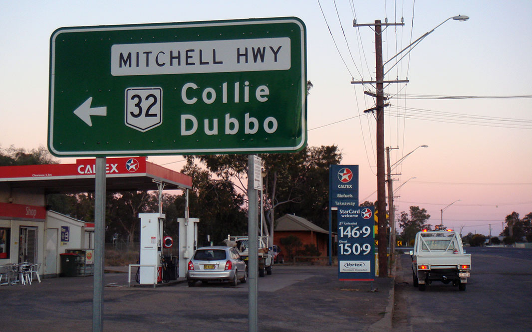
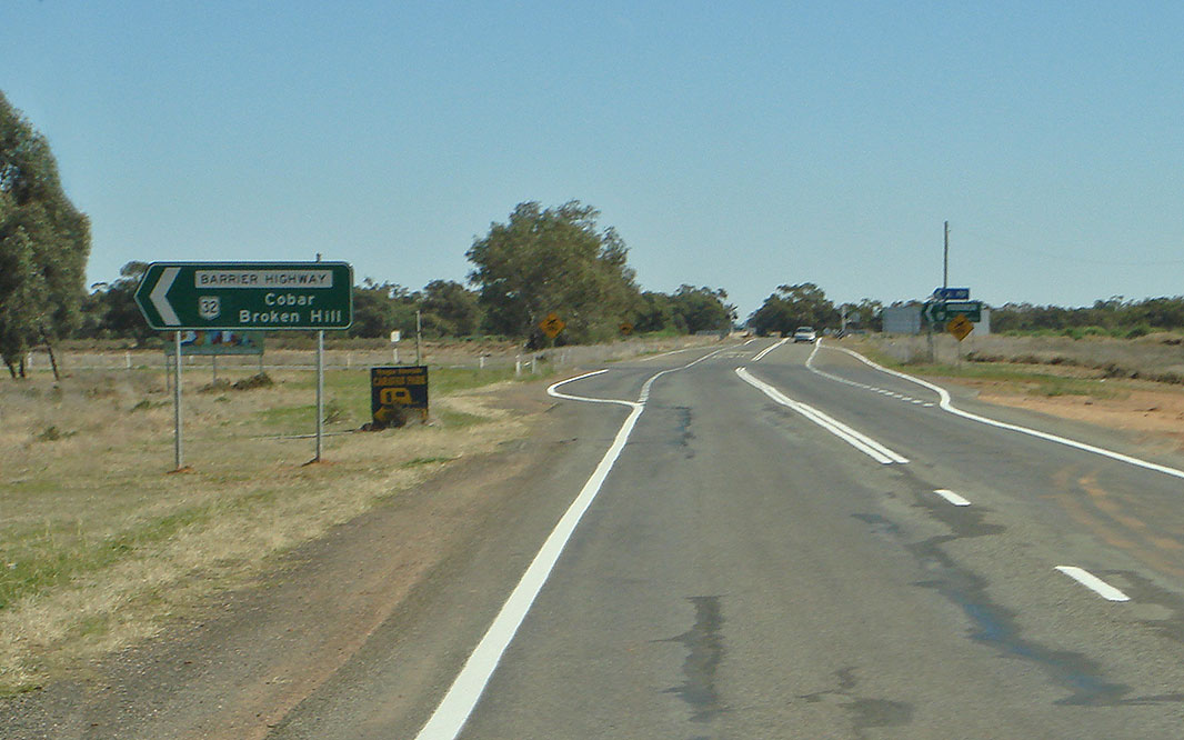
Advance Directional Sign: AD sign at Nyngan approaching Mitchell Hwy (NR71) and Barrier Hwy (NR32), August 2011. Click here for a photo of this location by Michael Greenslade from December 2003. Image © Paul Rands |
|||
 |
Intersection Directional Sign: ID sign at the corner of Barrier Hwy (NR32) and Mitchell Hwy (NR32 and NR71) at Nyngan, August 2011. NR32 turns left at this junction and becomes Barrrier Hwy. Image © Paul Rands |
|||
 |
Intersection Directional Sign: ID sign at the corner of Barrier Hwy (NR32) and Mitchell Hwy (NR32 and NR71) at Nyngan, August 2011. NR32 turns left at this junction and becomes Barrrier Hwy. Image © Paul Rands |
|||
 |
Reassurance Directional Sign: Distance sign at Nyngan, August 2011. Click here for a photo of this location by Michael Greenslade from December 2003. Image © Paul Rands |
|||
| Click here for the continuation of NR32 between Dubbo and Wellington Click here for the continuation of NR32 between Nyngan and South Australia |
||||
1 Roads and Traffic Authority, Schedule of Classified Roads (and unclassified Regional Roads),
25 February 2008
2 Department of Main Roads.
The Roadmakers, A History of Main Roads in New South Wales, ISBN 0
7240 0439 4
3 Roads & Traffic Authority, Community update, Road activity update – Western NSW, February 2003.
Last updated: 09-Sep-2020 23:29
This site © Paul Rands. All rights reserved. Some portions © (copyright) by their respective and credited owners. Permission must be obtained before using any images from this site. For details, please email by clicking here.