|
|
|
|
|
 |
Monaro Highway (National Route 23) - Bombala to Victoria Border (Decommissioned) |
Statistics:
Route Numbering:
General Information:
National Route 23 is a two-laned rural highway that travels through south eastern New South Wales. Parts of the route are subject to snow falls and ice during the winter months. The route continues out of the Australian Capital Territory, and passes through mostly farmland and small towns, with Cooma and Bombala being the 2 major towns on the route. At the southern end, the route passes through dense pine forests before crossing into the state of Victoria.
History:
| Victoria Border to Bombala | Bombala to Victoria Border | |||
| Preview: | Description: | Preview: | Description: | |
 |
NSW / Vic Border: Monaro Hwy as it crosses from Victoria to New South Wales, January 2010. B23 becomes NR23 in NSW. Image © Paul Rands |
 |
Entering Bombala: Monaro Hwy as it enters the town of Bombala, February 2010. Bombala is the last major town on the NSW side of the border along the Monaro Hwy. Image © Paul Rands |
|
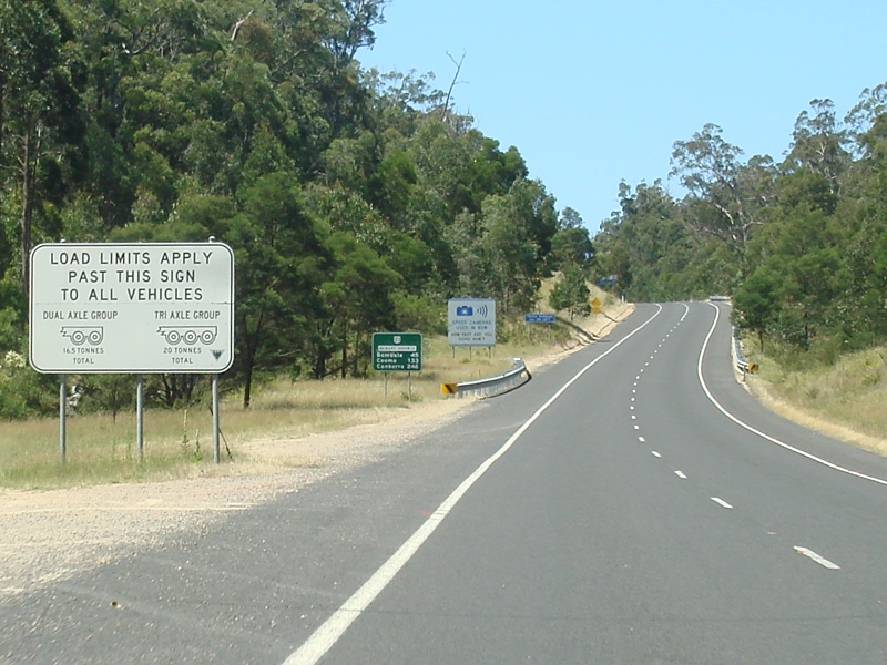 |
Load Limits Sign: Heavy vehicle load limits sign at Rockton, just over the border from Victoria, January 2010. Image © Paul Rands |
 |
Services Sign: Services sign for the Bombala River Rest Area at Bombala, February 2010. Image © Paul Rands |
|
 |
Distance Sign: First northbound RD sign, just north of the Victorian border at Rockton, January 2010. Image © Paul Rands |
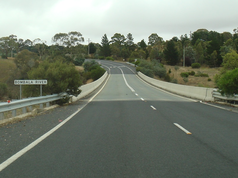 |
Bombala River: Monaro Hwy as it crosses the Bombala River at Bombala, February 2010. Image © Paul Rands |
|
 |
Advance Directional Sign: Services related AD sign for the truck parking area at Rockton, January 2010. Image © Paul Rands |
 |
Iris Street: Corner of Monaro Hwy and Iris St in Bombala, February 2010. Image © Paul Rands |
|
 |
Tourism Related Distance Sign: RD sign with tourist region name at Rockton, January 2010. Image © Paul Rands |
 |
Services Sign: Services sign approaching the turn off to the Bombala River Rest Area in Bombala, February 2010. Image © Paul Rands |
|
 |
Truck Parking Area: Monaro Hwy at the entrance to the truck parking area at Rockton, January 2010. Image © Paul Rands |
 |
Advance Directional Sign: AD sign at Bombala approaching the junction with Mahratta Street, February 2010. NR23 turns left at this intersection. Image © Paul Rands |
|
 |
Advance Directional Sign: Services related AD sign for the information bay at Rockton, January 2010. Image © Paul Rands |
 |
Intersection Directional Sign: ID sign at Bombala approaching the junction with Mahratta Street, January 2010. NR23 turns left at this intersection. Image © Paul Rands |
|
 |
Information Bay: Information bay entrance at Rockton, January 2010. Image © Paul Rands |
 |
Intersection Directional Sign: ID sign at Bombala at the junction with Mahratta Street, January 2010. NR23 turns left at this intersection. Note the good condition older style give way sign. Image © Paul Rands |
|
 |
Rockton Area: Monaro Hwy at the locality of Rockton, 40 km south of Bombala, January 2010. Image © Paul Rands |
 |
Bombala River: Monaro Hwy as it crosses the Bombala River in the Bombala town centre, February 2010. Image © Paul Rands |
|
 |
Hopping Joe Creek: Monaro Hwy as it crosses Hopping Joe Creek at Rockton, January 2010. Image © Paul Rands |
 |
Advance Directional Sign: AD sign on Monaro Hwy (Forbes St) approaching the roundabout with Maybe St, February 2010. NR23 turns right at this junction. Note the missing NR23 shield. Image © Paul Rands |
|
 |
AD Sign: Advance directional sign at Rockton for Imlay Road, January 2010. Image © Paul Rands |
 |
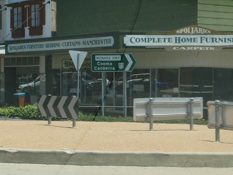
Forbes & Maybe Streets Roundabout: Corner of Forbes and Maybe Streets in Bombala, February 2010. NR23 turns right at this intersection. Image © Paul Rands |
|
 |
Genoa River: Monaro Highway as it crosses the Genoa River at Rockton, January 2010. Image © Paul Rands |
 |
Advance Directional Sign: AD sign on Maybe Street approaching Monaro Hwy (NR23) and Forbes Street in Bombala, January 2010. Image © Paul Rands |
|
 |
Imlay Road Intersection: Corner of Monaro Hwy and Imlay Rd at Rockton, January 2010. Image © Paul Rands |
 |
Forbes & Maybe Streets Roundabout: Corner of Forbes and Maybe Streets in Bombala, January 2010. Image © Paul Rands |
|
 |
Rockton Area: Monaro Hwy at the locality of Rockton, 25 km south of Bombala, January 2010. Image © Paul Rands |
 |
Forbes & Maybe Streets Roundabout: Corner of Forbes and Maybe Streets in Bombala, February 2010. Image © Paul Rands |
|
 |
Southern Access Road Intersection: Corner of Monaro Hwy and Southern Access Rd at Paddy's Flat, January 2010. Image © Paul Rands |
 |
Bombala Town Centre: Monaro Hwy (Maybe St) as it passes out of the Bombala Town Centre, January 2010. Image © Paul Rands |
|
 |
Outskirt Creek: Monaro Hwy as it crosses Outskirt Ck at Paddy's Flat, January 2010. Image © Paul Rands |
 |
Distance Sign: RD sign leaving Bombala town centre, January 2010. Note the missing NR23 shield Image © Paul Rands |
|
 |
Rock Flat Creek: Monaro Hwy at Paddy's Flat as it crosses Rock Flat Ck, January 2010. Image © Paul Rands |
 |
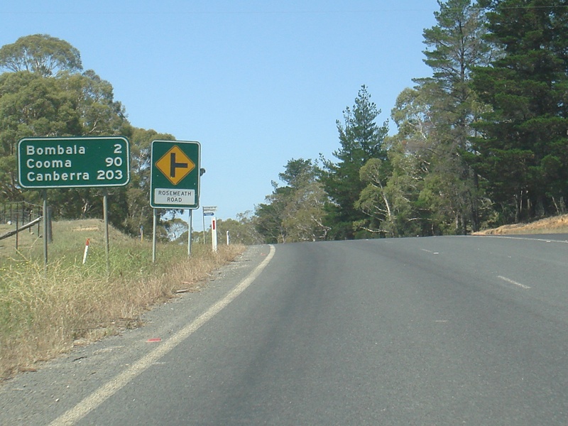
Approaching Rosemeath Road: Monaro Hwy as it approaches Rosemeath Rd at Bombala, January 2010. Image © Paul Rands |
|
 |
Mila Road: Corner of Monaro Hwy and Mila Rd at Paddy's Flat, January 2010. Image © Paul Rands |
 |
Advance Directional Sign: AD sign approaching Delegate Road at Bombala, January 2010. NR23 turns left at this intersection, but note the missing NR23 shield, not helpful if you're trying to follow route numbers. Image © Paul Rands |
|
 |
Dundundra Road: Corner of Monaro Hwy and Dundundra Rd at Paddy's Flat, January 2010. Image © Paul Rands |
 |
Delegate Road Junction: Corner of Monaro Hwy and Delegate Rd at Bombala, January 2010. NR23 turns left here. Image © Paul Rands |
|
 |
Outskirts of Bombala: Monaro Hwy as it approaches Bombala, January 2010. Image © Paul Rands |
 |
Distance Sign: RD sign leaving Bombala, January 2010. Note the missing NR23 shield. Image © Paul Rands |
|
 |
Parsonage Creek: Monaro Hwy as it passes over Parsonage Ck at Bombala, January 2010. Image © Paul Rands |
 |
Leaving Bombala: Typical scenery south of the Bombala town centre, January 2010. Image © Paul Rands |
|
 |
Advance Directional Sign: AD sign at Bombala approaching Delegate Rd, January 2010. Image © Paul Rands |
 |
Dundundra Road: Corner of Monaro Hwy and Dundundra Rd at Paddy's Flat, January 2010. Image © Paul Rands |
|
 |
Intersection Directional Sign Assembly: ID sign assembly at Bombala at the junction with Delegate Rd, January 2010. NR23 turns right at this junction. Image © Paul Rands |
 |
Mila Road: Corner of Monaro Hwy and Mila Rd at Paddy's Flat, January 2010. Image © Paul Rands |
|
 |
Distance Sign: RD sign as you enter Bombala, January 2010. Note the missing NR23 shield. Image © Paul Rands |
 |
Paddy's Flat: Monaro Hwy as it passes through Paddy's Flat, January 2010. Image © Paul Rands |
|
 |
Services Sign: AD sign for the Bombala River Rest Area at Bombala, January 2010. Image © Paul Rands |
 |
Rock Flat Creek: Monaro Hwy at Paddy's Flat as it crosses Rock Flat Ck, January 2010. Image © Paul Rands |
|
 |
Entering Bombala Town Centre: Monaro Hwy as it enters Bombala, January 2010. Image © Paul Rands |
 |
Paddy's River: Monaro Hwy at Paddy's River with the kilometre plate showing Cann River, January 2010. Image © Paul Rands |
|
 |
Bombala Town Centre: Monaro Hwy (Maybe St), Bombala, January 2010. Image © Paul Rands |
 |
Outskirt Creek: Monaro Hwy as it crosses Outskirt Ck at Paddy's Flat, January 2010. Image © Paul Rands |
|
 |
Forbes & Maybe Streets Roundabout: Corner of Forbes and Maybe Streets in Bombala, January 2010. NR23 turns left here. Image © Paul Rands |
 |
Link Road: Corner of Monaro Hwy and Link Rd at Paddy's Flat, January 2010. Image © Paul Rands |
|
 |
Forbes & Maybe Streets Roundabout: Corner of Forbes and Maybe Streets in Bombala, January 2010. NR23 turns left here. Image © Paul Rands |
 |
Southern Access Road Intersection: Corner of Monaro Hwy and Southern Access Rd at Paddy's Flat, January 2010. Image © Paul Rands |
|
 |
Bombala River: Monaro Hwy as it crosses the Bombala River in the Bombala town centre, January 2010. Image © Paul Rands |
 |
Steep Descent: Monaro Hwy as it passes through pine forests at Rockton, January 2010. Image © Paul Rands |
|
 |
Intersection Directional Sign: ID sign at Bombala at the junction with Mahratta Street, January 2010. NR23 turns right at this intersection Image © Paul Rands |
 |
Rockton Area: Monaro Hwy as it passes through the Rockton area, January 2010. Image © Paul Rands |
|
 |
Distance Sign: RD sign leaving Bombala, January 2010. Note the missing NR23 shield. Image © Paul Rands |
 |
Steep Descent: Monaro Hwy as it passes through Rockton, January 2010. Image © Paul Rands |
|
 |
Iris Street: Corner of Monaro Hwy and Iris St in Bombala, January 2010. Image © Paul Rands |
 |
Rockton Area: Monaro Hwy as it passes through the Rockton area, January 2010. Image © Paul Rands |
|
 |
Bombala River: Monaro Highway as it leaves Bombala and crosses the Bombala River, January 2010. Image © Paul Rands |
 |
AD Sign: Advance directional sign at Rockton for Imlay Road, January 2010. Image © Paul Rands |
|
 |
AD Sign: Advance directional sign at Rockton for Imlay Road, January 2010. Image © Paul Rands |
|||
 |
Imlay Road Intersection: Corner of Monaro Hwy and Imlay Rd at Rockton, January 2010. Image © Paul Rands |
|||
 |
Fingerboard Assembly: Fingerboard assembly at Rockton facing Imlay Road. Note the NR19 shield, it's in error, it should be NR23. It's likely the sign designer mixed up National Route 23 with the road authority's internal number, Highway No 19, January 2010. Image © Paul Rands |
|||
 |
Genoa River: Monaro Highway as it crosses the Genoa River at Rockton, January 2010. Image © Paul Rands |
|||
 |
Plaque: Roadside plaque at Rockton for the Genoa River Bridge, which opened on May 3, 1991, image taken January 2010. Image © Paul Rands |
|||
 |
Hopping Joe Creek: Monaro Hwy as it crosses Hopping Joe Creek at Rockton, January 2010. Image © Paul Rands |
|||
 |
Advance Directional Sign: Services related AD sign for the truck parking area at Rockton, January 2010. Image © Paul Rands |
|||
 |
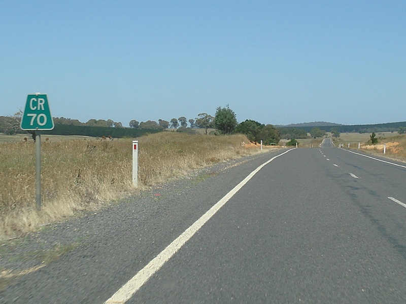
Kilometre Plate: Kilometre plate at Rockton near the Victorian border. CR is short for Cann River, January 2010. Image © Paul Rands |
|||
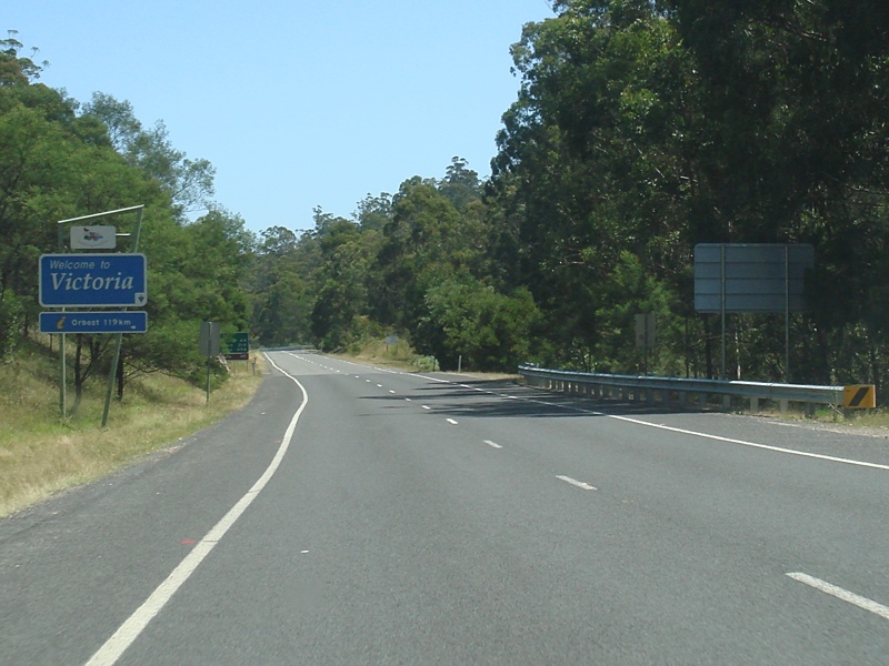 |
Victorian Border: NR23 (Monaro Hwy) as it crosses into Victoria, January 2010. NR23 changes to B23 as it crosses the border. Image © Paul Rands |
|||
| Click here for the continuation of NR23 as B23 in Victoria Click here for the continuation of NR23 between Bombala and Cooma |
||||
1 NSW Treasury
Last updated: 18-Dec-2019 13:09
This site © Paul Rands. All rights reserved. Some portions © (copyright) by their respective and credited owners. Permission must be obtained before using any images from this site. For details, please email by clicking here.