Road
Photos & Information: New South Wales
 |
|
Hume Highway (National Highway 31) - Coolac to Gundagai: Former Alignment (Decommissioned) |
Statistics:
- Length: 500 km (Coolac to Gundagai: 22 km)
- Northern Terminus: Narellan Road (Metroad 9) interchange at Mt Annan, near Campbelltown on the outskirts of southwestern Sydney.
- Southern Terminus: NSW-Vic border at Albury
- Miscellaneous: Continues as Hume Freeway (NH-M31) at the Victorian border and travels for 303 km to the Metropolitan Ring Road (M80).
- Suburbs, Towns & Localities along route: Cambelltown, Wilton, Tahmoor, Bargo, Mittagong, Berrima, Sutton Forest, Marulan, Goulburn, Gunning, Yass, Jugiong, Coolac, Gundagai, Tarcutta, Holbrook and Albury.
Route Numbering:
- Former:

- Decommissioned: 2013
- Road Authority Internal Classification: State Highway 2
General Information:
The Hume Highway is one of Australia's most vital highway links. Providing access between Sydney and Melbourne, Australia's 2 largest cities. The National Highway section of the Hume Highway consists of almost 100% dual carriageway road, either rural expressway or motorway standard. Works to duplicate small sections of highway that are not dual carriageway are well underway.
In NSW, the highway in one form or another started life as the Great South Road, linking Sydney with the southern highlands and eventually beyond. The highway was named in 1928 after Hamilton Hume (1797-1873), a famous explorer in the early 19th century who, in 1824, in conjunction with William Hovell first found an overland route between Sydney and the infant colonial outpost of Port Phillip, the original name of Melbourne.
NH31 is the main freight and commuter route between Sydney and Melbourne and has gone through a massive amount of transformation over the past 30 or so years, with many towns being bypassed along its route as well and gradual upgrades to motorway standards. Since the 1960s, the road has either been duplicated, where alignments allow for it, and also large deviations have also been part of the upgrade process.
The route around the Mittagong area averages around 16,000 vehicles every day, in other sections the number drops off a little or closer to Sydney increases.1
The route forms the Remembrance Driveway which honours war veterans, click here for the Remembrance Driveway web site.
Here are some interesting statistics on the Hume Highway: 2
- The Jugiong Bypass, features 13 km of dual carriageways.
History (Covers Entire Hume Hwy Length in NSW):
- 1914: Sydney-Melbourne road (Great South Road) is declared a main road
- 1920: Cullerin Range route built on abandoned sections of the old Main Southern Railway
- 1928: Sections of Great South Road renamed to Hume Highway
- 1930s: Raising of the wall of the Hume Dam on the Murray River forced the highway to be realigned north of Albury. Also during the 1930s the Marulan section of Hume Hwy was concreted from Mt. Otway to Marulan South.
- 1931: Lorry checking station built at Marulan.4
- December 1938: Tumbalong-Tarcutta deviation construction, a major roadworks project which was partly funded under the significant Unemployment Relief Works Programme. 2
- 1940: Hume Highway is (mostly) paved.
- 1942: Construction of Ten Mile Creek Bridge at Holbrook 2
- 1950s: In 1952, a group of citizens met and formed a committee under Lt-General Sir Frank
Berryman to create a national memorial to servicemen by using trees and shrubs as living
memorials. The NSW Premier, JJ Cahill, officially launched the scheme on 9 December
1953. The Remembrance Driveway project as it was called started on 5 February 1954,
when trees were planted at either end of the Driveway at the War Memorial, Canberra,
and in Macquarie Place, Sydney, by the Queen and the Duke of Edinburgh. By June 1959, 10,000 trees had been planted. Since then, planting of trees in avenues or groves has
continued. When the M5 Motorway replaced the Hume Highway (and also Camden Valley Way) south of Liverpool, it
became the focus for planting trees and shrubs in remembrance. 2
- 1951: Upgrade of old timber Cabramatta Creek Bridge, also known as Ireland's Bridge, at Cabramatta, to then modern standards. Also planning for the F5 Freeway (South Western Fwy) 2
- 1957: An additional carriageway for the highway was completed at Lansvale 2
- 1958 Truck weighstation built further out of Marulan along the highway, replacing the one built in 1931.4
- 1959: an experiment using advisory speed
signs on curves on the Hume Highway between Camden and Berrima was successful and
was extended to other roads. 2
- 1960s: The route over the Mundoonen Range rebuilt in the 1960s - it was designed to be duplicated.
- December 1962: A major project on traffic management was the completion of a set of overhead traffic
signs and signals at Villawood where Woodville Road, Henry Lawson Drive and the
Hume Highway met. Due to large traffic volumes at this intersection, it was selected as a
suitable location to install the system. The site has become known over the years, as the "Meccano set". 2
- 1970s: Construction of high standard 4 lane freeway between Campbelltown and Prestons, DMR also built another high standard 4 lane road between Bargo and Alpine (near Mittagong)
- 1970: Dual carriageway and new bridges built, bypassing the old bridge from 1930s at Boxers Creek, north of Goulburn 2
- 1974: South Western Freeway extended to Narellan Road near Campbelltown.
- 26 October 1973: A six
mile (9.7 km) section of the South Western Freeway (formerly F5, now Hume Hwy (Metroad 5) from Cross Roads to Raby Road opened. 2
- May 1977: South Western Freeway between Yanderra and Alpine opens to traffic
- 1979: The area south of Connors Creek was rebuilt with the earthworks being done for a second carriageway, which was built in 1994.
- December 1980: Opening of freeway between Campbelltown and Yanderra north of Mittagong. This section of the Hume Hwy features the highest bridge ever built in NSW was the Pheasants Nest Bridge across the Nepean River, which is 76 metres above water level. 2 When this section was built, it formed part of the longest freeway in Australia at the time and won the DMR world wide design and engineering awards.
- 1983: The highway between Conroys Gap and Coolac, had most of the earlier alignment replaced, also a new Tarcutta deviation completed - 11.5 kilometres in length. This bypassed the bowstring arch across Hillas Creek from the 1930s. The new section of road featured a dual carriageway.2
- 1986: Marulan Bypass opens, with new truck weighstations (those were built in 1985 4)
- March 1989: Berrima was bypassed by the South Western Freeway 3
- 1992: Mittagong and Goulburn Bypasses open
- 1994: Most of the highway route between Breadalbane, west of Goulburn, and Derringullen Creek, west of Yass, was deviated. This included a bypassing of the Cullerin Range
- 2002: Replacement of bridges over Nattai River and Gibbergunyah Creek near Mittagong 1
- March 2007: Albury Bypass opens. The freeway was officially opened by the Prime Minister John Howard at a community event on 4 March 2007. The freeway opened to traffic on 6 March 2007. 2
| |
| |
 |
Divided Road Ends:
Signs warning the divided carriageway ends approaching Coolac. December 2007. These signs are now removed and the dual carriageway bypasses Coolac.
Image © Paul Rands |
|
 |
Distance Sign:
Northbound RD sign leaving Coolac. December 2007.
Image © Paul Rands |
 |
Coolac:
Hume Hwy entering Coolac, December 2007.
Note the duplication works in the distance.
Image © Paul Rands |
|
|
|
 |
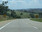
Single Carriageway:
Undivided Hume Highway passing through the hills north of Coolac. December 2007.
Image © Paul Rands |
|
|
|
 |
Crash Zone Sign:
Sign indicating this section of the highway has a higher risk of head on crashes, Coolac, December 2007.
Image © Paul Rands |
|
|
|
 |
Typical Conditions:
Southbound at Coolac, December 2007.
Image © Paul Rands |
|
|
|
 |
Entering Coolac Town Centre:
Southbound as you enter the town centre of Coolac, which consists of a few buildings. December 2007.
Note the heavy vehicle inspection bay sign in the distance.
Image © Paul Rands |
|
|
|
 |
Advance Directional Sign:
Southbound at Coolac approaching Gundagai Road, December 2007.
Image © Paul Rands |
|
|
|
 |
Town Centre:
Passing the Coolac store. southbound, December 2007.
Image © Paul Rands |
|
|
|
 |
Distance Sign:
Southbound RD sign as you leave the town centre of Coolac, December 2007.
Image © Paul Rands |
|
|
|
 |
Load Limits Signage:
Southbound sign for heavy vehicles indicating maximum vehicle masses. Coolac, December 2007.
Image © Paul Rands |
|
|
|
 |
Leaving Coolac:
Southbound at Coolacon the concrete pavement, which at the time was being duplicated. December 2007.
Image © Paul Rands |
|
|
|
 |
Advance Directional Sign:
Southbound tourist based AD for the Dog On The Tuckerbox, 8 km north of Gundagai, December 2007. This section is now dual carriageway and features new signs.
Image © Paul Rands |
|
|
|
 |
Advance Directional Sign:
Diagrammatic AD sign for Middle Street South Gundagai at the merge to single carriageway to cross the Murrumbidgee River, December 2007.
Image © Paul Rands |
|
|
|
 |
Murrumbidgee River:
Crossing the Murrumbidgee River at Gundagai, via Sheahan Bridge. Southbound, December 2007.
Image © Paul Rands |
|
|
|
 |
Sheahan Bridge:
Crossing the Murrumbidgee River at Gundagai, December 2007.
Image © Paul Rands |
|
|
|
1 Department of Infrastructure, Transport, Regional Development and Local Government
2 Roads and Traffic Authority
3 Berrima Business Houses
4 Argyle County web site
Last updated: 17-Dec-2019 0:55
This site ©
Paul Rands. All rights reserved. Some portions © (copyright) by their respective and credited owners. Permission must be obtained before using any images from this site. For details, please email by clicking here.


