|
|
|
|
|
 |
Barton Highway (National Highway 25) - Lyneham to Nicholls |
Statistics:
Route Numbering:

General Information:
The Barton Highway, National Highway 25, is a short highway connecting Canberra to the Hume Highway at Yass, and it is part of the route from Melbourne to Canberra
Most roads connecting to the Barton Highway are at-grade intersections (using standard junctions, signals or roundabouts), with the exception of Gunghalin Drive, which features a full grade separated interchange, as part of the greater Gungahlin Drive Extension.
The Barton Highway is named after Australia's first Prime Minister, Sir Edmund Barton, who served between 1901 and 1903. He was also a barrister and Member of the New South Wales Parliament and one of the leading workers for Federation, serving on the Committee which prepared the draft for the Constitution. He resigned from Parliament in 1903 to become the Senior Puisne Judge of the newly constituted High Court of Australia. 1
History:
| Nicholls to Lyneham | Lyneham to Nicholls | |||
| Preview: | Description: | Preview: | Description: | |
 |
Road Safety Sign: One of several road safety signs along the Barton Hwy, Crace, December 2009. Image © Paul Rands |
 |
Road Safety Sign: One of several road safety signs along the Barton Hwy, Lyneham, December 2009. Image © Paul Rands |
|
 |
Bellenden Street Junction: Barton Hwy approaching Bellenden St in Crace. Prior to the opening of Gungahlin Drive, this road was a through road, December 2009. Image © Paul Rands |
 |
Distance Sign: The first RD sign on the Barton Hwy heading outbound, Lyneham, December 2009. Image © Paul Rands |
|
 |
National Highway Sign: Old sign leftover from duplication works at Crace near Bellenden Street. The highway was widened and duplicated between Ellenborough Street Lyneham and the Crace / Giralang area in 2001. July 2006. Sign has since been removed. Image © Paul Rands |
 |
Tourist Attraction Distance Sign: RD sign at Lyneham for tourist attractions, December 2009. Image © Paul Rands |
|
 |
Diagrammatic AD Sign: Advance directional sign at Crace approaching Gungahlin Drive, December 2009. Image © Paul Rands |
 |
Advance Directional Sign: Eastbound AD sign approaching Randwick Road, near the racecourse at Lyneham. December 2009. Image © Paul Rands |
|
 |
Approaching Gungahlin Drive: Interchange with Gungahlin Drive at Crace. December 2009. Click here for a photo of this junction from July 2006. Image © Paul Rands |
 |
Advance Direction Sign: AD sign approaching Ellenborough Street at Lyneham, December 2009. Image © Paul Rands |
|
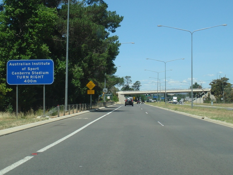 |
Supplemental Advance Directional Sign: Supplemental AD sign for the Australian Institute of Sport, as you approaching Gungahlin Drive at Crace, December 2009. Image © Paul Rands |
 |
Ellenborough Street Intersection: Corner of Barton Hwy & Ellenborough St at Lyneham, December 2009. Ellenborough St used to be an alignment of the Barton Hwy. Image © Paul Rands |
|
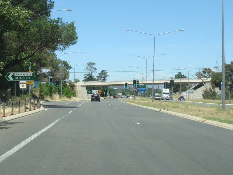 |
Gungahlin Drive: Interchange with Gungahlin Drive at Crace. December 2009. Click here for a photo of this junction from July 2006. Image © Paul Rands |
 |
Diagrammatic AD Sign: Advance directional sign at Kaleen approaching Gungahlin Drive, December 2009. Image © Paul Rands |
|
 |
Gungahlin Drive Interchange: Looking southeast on Barton Hwy (NH25) at the interchange with Gungahlin Drive, December 2009. Image © Paul Rands |
 |
Approaching Gungahlin Drive: Interchange with Gungahlin Drive at Kaleen. December 2009. Image © Paul Rands |
|
 |
Gungahlin Drive Interchange: Looking southeast on Barton Hwy (NH25) at the interchange with Gungahlin Drive, December 2009. Image © Paul Rands |
 |
Gungahlin Drive Interchange: Interchange with Gungahlin Drive at Kaleen. December 2009. Image © Paul Rands |
|
 |
Intersection Directional Sign: ID sign facing Gungahlin Drive at Kaleen, May 2010. Image © Paul Rands |
 |
Intersection Directional Sign: ID sign on the outbound ramp to Gungahlin Drive at Kaleen, December 2009. Image © Paul Rands |
|
 |
Intersection Directional Sign: ID sign on the inbound ramp to Gungahlin Drive at Mitchell, December 2009. Image © Paul Rands |
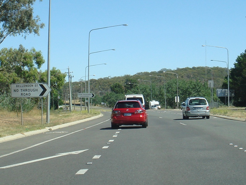 |
Bellenden Street Junction: Barton Hwy approaching Bellenden St in Crace. Prior to the opening of Gungahlin Drive, this road was a through road, December 2009. Image © Paul Rands |
|
 |
Ellenborough Street Turn Off: The location at which the highway used to continue, via Ellenborough Street. There is no evidence, apart from old maps that show that Ellenborough & Mouat Streets were once the Barton Highway. December 2009, eastbound at Mitchell. Image © Paul Rands |
 |
Road Safety Sign: One of several road safety signs along the Barton Hwy, Kaleen, December 2009. Image © Paul Rands |
|
 |
Advance Directional Sign: Eastbound AD sign approaching Randwick Road, near the racecourse at Mitchell. December 2009. Click here for a photo of this sign, taken in July 2006. Image © Paul Rands |
 |
Advance Directional Sign: AD sign at Giralang approaching William Slim Drive and Gundaroo Drive, December 2009. Image © Paul Rands |
|
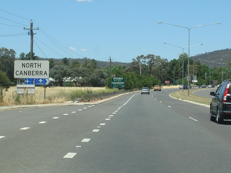 |
Entering North Canberra: Barton Hwy as it enters the North Canberra region, December 2009. Image © Paul Rands |
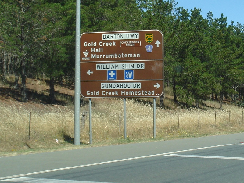 |
Supplemental Advance Directional Sign: Supplemental AD sign at Giralang approaching William Slim Drive and Gundaroo Drive, December 2009. Image © Paul Rands |
|
 |
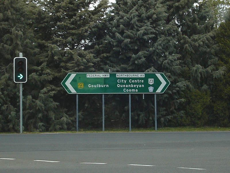
Advance Directional Sign: Advance directional sign as you approach the junction with the Federal Highway & Northbourne Avenue, at Mitchell. December 2009. Click here for a photo of this sign from July 2006. Image © Paul Rands |
|||
 |
Supplemental Advance Directional Sign: Supplemental AD sign on Barton Highway approaching the junction with the Federal Highway (NH23) and Northbourne Avenue (NR23) at Lyneham, December 2009. Note the incorrect NH25 shield. Image © Paul Rands |
|||
 |
Truck Route Sign: Truck route signage approaching Northbourne Avenue in Lyneham, December 2009. Image © Paul Rands |
|||
 |
End National Highway 23: The southern terminus of the Federal Highway at Downer, the road continues are Northbourne Avenue, National Route 23. Southbound, July 2006. Image © Paul Rands |
|||
| Click here for the continuation of NH25 between Nicholls and the NSW Border | ||||
1 ACT Planning & Land Authority, Place Name Search, Barton Highway
2 Legislative Assembly for the ACT, Standing Committee for the Environment, Variation to the Territory Plan No .224, May 2004
3 ACT Department of Urban Services, Annual Report, 2002-03
Last updated: 03-Dec-2019 13:35
This site © Paul Rands. All rights reserved. Some portions © (copyright) by their respective and credited owners. Permission must be obtained before using any images from this site. For details, please email by clicking here.